Welcome to Fashionplate Dan Bedore's Hiking World
| 2020 Winter Writing Season | ||||
|---|---|---|---|---|
| As I add photographs, research, etcetera, to my 2019 journals, I will place them here. There will be additional pages on topics related to the Pinhoti National Recreation Trail. I anticipate writing through February 2020 on projects backlogged from 2019. | ||||
| Pinhoti Trail Research | ||||
| The Future of the Pinhoti Trail | 2019 / | 2020 | ||
| Visiting CCC Sites from the Pinhoti Trail | - | |||
| 7½' Topo Maps of the Pinhoti Trail | - | |||
| Alabama Pinhoti Trail Log Books | ||||
| Comments on Many Pinhoti Log Books | 2006 - | 2019 | ||
| Oakey Mountain Shelter Log Book | 2018 - | 2019 | ||
| Lower Shoal Shelter Log Book | 2014 - | 2016 | ||
| Lower Shoal Shelter Log Book - !partial! | 2016 - | 2017 | ||
| Flagg Mountain Trails Log Book | 2006 - | 2018 | ||
| 2019 Road Trip Journals Before Photos and Research | ||||
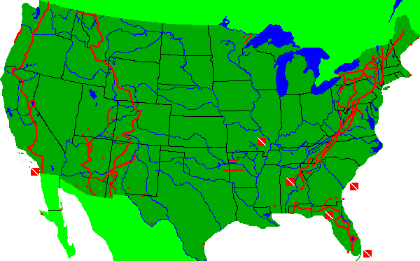
| Maps of the 48 states and an introduction to the plan. | ||||
| San Diego - Flagstaff | Deserts | January - | February | |
| Arizona + California | Deserts | February - | March | |
| Grand Canyon, Nearby | Sunset, Wupatki, Walnut | March - | April | |
| Meteor, Petrified Forest | Grand Staircase - Escalante | April - | July | |
| Great Basin, San Diego | Cedar Breaks, Mono Lake | August - | September | |
| Four Corners | Arizona, Utah, Colorado, New Mexico | September - | October | |
| Tin Can Dumps | Western Deserts and Mountains | - | ||
| Old Forest Phone Systems | National Forests, Grand Canyon | - | ||
| Arizona Maps | Arizona | - | ||
Map Index to my United States Hikes
Click on Trails to Link to my Journals
Dwell Cursor over Trails for Trip Name

The Pacific Crest National Scenic Trail

2018 PCT San Diego to Washington Hike
![]() San Diego -Tehachapi, April - June
San Diego -Tehachapi, April - June
![]()
![]() Lone Pine - Sierra City, TYT, June - August
Lone Pine - Sierra City, TYT, June - August
![]()
![]() N California, Sierra City - Etna Summit, August
N California, Sierra City - Etna Summit, August
![]()
![]() Oregon - Southern Washington, August - September
Oregon - Southern Washington, August - September
![]()
The Troubles That Trees Have, PCT, 2018
Introduction
Ax Blazes
Nails, Signs, and other Hardware
Insects, Mammals, and Birds
How Stumps Heal
Wildfire
2015 PCT Mexico to Mount Hood Walk
![]() Near the PCT, Mexico - Cajon Junction, April - May, 2015
Near the PCT, Mexico - Cajon Junction, April - May, 2015
![]()
![]() West of the PCT, Lone Pine to Tuolumne, June - July, 2015
West of the PCT, Lone Pine to Tuolumne, June - July, 2015
![]()
![]() Pacific Crest Trail, Tuolumne to Oregon, July - August, 2015
Pacific Crest Trail, Tuolumne to Oregon, July - August, 2015
![]()
![]() Pacific Crest Trail, Oregon through Mount Hood, August, 2015
Pacific Crest Trail, Oregon through Mount Hood, August, 2015
![]()
2013 PCT Southern California Hike
![]() Pacific Crest Trail, A-G, Mexico to Kennedy Meadows, Spring 2013
Pacific Crest Trail, A-G, Mexico to Kennedy Meadows, Spring 2013
![]()
![]() Pacific Crest Trail, H-K, Kennedy Meadows to Truckee, Summer 2013
Pacific Crest Trail, H-K, Kennedy Meadows to Truckee, Summer 2013
![]()
![]() Pacific Crest Trail, A-K, Mexico to Truckee, GPS Table, 2013
Pacific Crest Trail, A-K, Mexico to Truckee, GPS Table, 2013
![]()
2003 PCT Thru Hike
![]() PCT, Mexico to Pink Motel, A-C, April 2003
PCT, Mexico to Pink Motel, A-C, April 2003
![]()
![]() PCT, Pink Motel to Cottonwood Creek, C-E, May 2003
PCT, Pink Motel to Cottonwood Creek, C-E, May 2003
![]()
![]() PCT, Cottonwood Creek to Vermillion Valley, E-H, June 2003
PCT, Cottonwood Creek to Vermillion Valley, E-H, June 2003
![]()
![]() PCT, Vermillion Valley to Burney Falls, H-N, July 2003
PCT, Vermillion Valley to Burney Falls, H-N, July 2003
![]()
![]() PCT, Burney Falls to Mount Hood, O-G, August 2003
PCT, Burney Falls to Mount Hood, O-G, August 2003
![]()
![]() PCT, Mount Hood to Stehekin, G-K, September 2003
PCT, Mount Hood to Stehekin, G-K, September 2003
![]()
![]() PCT, Stehekin to Canada, K, October 2003
PCT, Stehekin to Canada, K, October 2003
![]()
![]() Why I hiked the Pacific Crest Trail, 2003
Why I hiked the Pacific Crest Trail, 2003
![]()
![]() PCT Advice, 2003
PCT Advice, 2003
![]()
In the PCT Corridor
![]() Sierra Nevadas, Taboose Pass, Lakes Basin, Jim, 2017
Sierra Nevadas, Taboose Pass, Lakes Basin, Jim, 2017
![]()
![]() Map: Sierra Nevadas, Taboose Pass, Lakes Basin, Jim, 2017
Map: Sierra Nevadas, Taboose Pass, Lakes Basin, Jim, 2017
![]()
![]() Sierra Nevadas, Pasayten, Olympics with Jim, 1990s-2008
Sierra Nevadas, Pasayten, Olympics with Jim, 1990s-2008
![]()
![]() Sierra Nevada, Lone Pine - Emigrant Wilderness, 2017
Sierra Nevada, Lone Pine - Emigrant Wilderness, 2017
![]()
![]() Kern River and Sierra High Route, California, 2012
Kern River and Sierra High Route, California, 2012
![]()
![]() Tahoe Rim Trail, California and Nevada, 2012
Tahoe Rim Trail, California and Nevada, 2012
![]()
![]() Anza Borrego, Cuyamacas, & Lagunas, 2014
Anza Borrego, Cuyamacas, & Lagunas, 2014
![]()
![]() Off the PCT in Southern California, 2015
Off the PCT in Southern California, 2015
![]()
![]()
![]() California's Spanish Missions, 2015
California's Spanish Missions, 2015
![]()
![]()
![]() San Diego's Mission Bay Area, 2014
San Diego's Mission Bay Area, 2014
![]()
![]() PCT, Southern California, 2014
PCT, Southern California, 2014
![]()
![]() PCT, Washington, I-K, 1998
PCT, Washington, I-K, 1998
![]()
![]() North Oregon Coast, 2014
North Oregon Coast, 2014
![]()
San Diego, Winter 2016-17
San Diego, Winter 2017-18
![]() Sierra Nevada, 2014
Sierra Nevada, 2014
![]()
![]() Maps of the Pacific Crest Corridor
Maps of the Pacific Crest Corridor
![]()
Arizona Hikes
![]()
![]() Arizona National Scenic Trail, 2012
Arizona National Scenic Trail, 2012
![]()
![]()
![]()
![]() Arizona Trail, Flagstaff to Phoenix, 2013
Arizona Trail, Flagstaff to Phoenix, 2013
![]()
![]()
![]()
![]() Grand Enchantment Trail, Arizona and New Mexico, 2012
Grand Enchantment Trail, Arizona and New Mexico, 2012
![]()
![]()
![]()
![]() Maps of the Arizona Trail Corridor
Maps of the Arizona Trail Corridor
![]()
![]()
The Continental Divide National Scenic Trail
![]()
![]() Continental Divide Trail - New Mexico, Official, 2014
Continental Divide Trail - New Mexico, Official, 2014
![]()
![]()
![]()
![]() Continental Divide Trail - New Mexico, Wolf, 2011
Continental Divide Trail - New Mexico, Wolf, 2011
![]()
![]()
![]()
![]() Continental Divide Trail, Colorado and Wyoming, 2012
Continental Divide Trail, Colorado and Wyoming, 2012
![]()
![]()
![]()
![]() Continental Divide Trail, Wyoming, 2013
Continental Divide Trail, Wyoming, 2013
![]()
![]()
![]()
![]() Continental Divide Trail, Montana and Idaho, 2013
Continental Divide Trail, Montana and Idaho, 2013
![]()
![]()
![]()
![]() Montana, Idaho, and Wyoming CDT GPS Table, 2013
Montana, Idaho, and Wyoming CDT GPS Table, 2013
![]()
![]()
The Great Divide Mountain Bike Route
![]() Bike Notes, 2015
Bike Notes, 2015
![]()
![]() GDMBR, Montana, 2016
GDMBR, Montana, 2016
![]()
![]() GDMBR, Wyoming, 2016
GDMBR, Wyoming, 2016
![]()
![]() GDMBR, Colorado, 2016
GDMBR, Colorado, 2016
![]()
![]() GDMBR, New Mexico, 2016
GDMBR, New Mexico, 2016
![]()
In the CDT Corridor
![]() Pacific Northwest Trail - Montana & Idaho, 2014
Pacific Northwest Trail - Montana & Idaho, 2014
![]()
![]()
![]() Grand Enchantment Trail, Arizona and New Mexico, 2012
Grand Enchantment Trail, Arizona and New Mexico, 2012
![]()
![]()
![]()
![]()
![]() Maps of the Continental Divide Corridor
Maps of the Continental Divide Corridor
![]()
![]()
![]()
The Appalachian National Scenic Trail
![]()
![]() Appalachian Trail - Georgia, North Carolina, and Tennessee, 2013
Appalachian Trail - Georgia, North Carolina, and Tennessee, 2013
![]()
![]()
![]()
![]() Appalachian Trail, Tennessee - Virginia, 2016
Appalachian Trail, Tennessee - Virginia, 2016
![]()
![]()
![]()
![]() AT, Shenandoah NP to Duncannon, 2016
AT, Shenandoah NP to Duncannon, 2016
![]()
![]()
![]()
![]() AT, Pennsylvania - Massachusetts, 2016
AT, Pennsylvania - Massachusetts, 2016
![]()
![]()
![]()
![]() Appalachian Trail, Vermont - Maine, 2016
Appalachian Trail, Vermont - Maine, 2016
![]()
![]()
![]()
![]() Appalachian Trail - Maine and New Hampshire, 2010
Appalachian Trail - Maine and New Hampshire, 2010
![]()
![]()
In the Appalachian Corridor
![]()
![]() Vermont's Long Trail, 2016
Vermont's Long Trail, 2016
![]()
![]()
![]() C&O Canal, GAP, PHT, 2016
C&O Canal, GAP, PHT, 2016
![]()
![]() Tuscarora Trail, 2016
Tuscarora Trail, 2016
![]()
Alabama to New York off of the AT, 2017
![]() Pinhoti National Recreation Trail, AL-GA, 2017
Pinhoti National Recreation Trail, AL-GA, 2017
![]()
![]() Benton MacKaye, Bartram, Foothills, GA-SC, 2017
Benton MacKaye, Bartram, Foothills, GA-SC, 2017
![]()
![]() Mountains to Sea Trail, Blue Ridge, North Carolina, 2017
Mountains to Sea Trail, Blue Ridge, North Carolina, 2017
![]()
![]() Allegheny, Headwaters, Tuscarora Trails, WV-VA, 2017
Allegheny, Headwaters, Tuscarora Trails, WV-VA, 2017
![]()
![]() C&O, Mid State Trail, Maryland-Pennsyvania, 2017
C&O, Mid State Trail, Maryland-Pennsyvania, 2017
![]()
![]() Finger Lakes, North Country Trails, NY, 2017
Finger Lakes, North Country Trails, NY, 2017
![]()
![]() Trail by Trail Plan, Georgia-New York, 2017
Trail by Trail Plan, Georgia-New York, 2017
![]()
![]()
![]() My Maps of the Appalachian Trail Corridor
My Maps of the Appalachian Trail Corridor
![]()
![]()
![]()
![]() Maps of the Potomac Heritage Trail Corridor
Maps of the Potomac Heritage Trail Corridor
![]()
![]()
![]() Map of Southeast Trails and Maps
Map of Southeast Trails and Maps
![]()
![]() Map of Northeast Trails and Maps
Map of Northeast Trails and Maps
![]()
South Eastern United States Hikes
![]() Hiking near Marietta
Hiking near Marietta
![]()
![]()
![]() Pinhoti Trail, 2011
Pinhoti Trail, 2011
![]()
![]()
![]()
![]() More Pinhoti Trail
More Pinhoti Trail
![]()
![]()
![]() Cumberland Island Hikes
Cumberland Island Hikes
![]()
![]() Ave Maria Grotto, Alabama
Ave Maria Grotto, Alabama
![]()
![]() Tennessee's Cumberland Trail, 2015
Tennessee's Cumberland Trail, 2015
![]()
ALDHA, Alabama, Georgia, Fall 2018
![]() Alabama Trail and Conecuh Trail Hikes
Alabama Trail and Conecuh Trail Hikes
![]()
![]() Silver Comet & Chief Ladiga Trails Hike
Silver Comet & Chief Ladiga Trails Hike
![]()
![]()
![]() The Ozark Highlands Trail, Arkansas, 2011
The Ozark Highlands Trail, Arkansas, 2011
![]()
![]()
![]()
![]() The Ouachita Trail, Arkansas & Oklahoma, 2011
The Ouachita Trail, Arkansas & Oklahoma, 2011
![]()
![]()
John's Pinhoti
These pages document the passion and knowledge of John Calhoun,
Mother Nature's Son, Mr Pinhoti, about the
Pinhoti National Recreation Trail
Introduction and Photos South to North
More Photos along the Pinhoti Trail
Coosa Trail, Southern Pinhoti Extension
Airplane Crashes near the Pinhoti Trail
Landmarks along the Pinhoti Trail
Backcountry Camping Shelters of the Pinhoti Trail
Comments on the 2014 USFS Pinhoti Map
100 Trailheads and Access Points
Maintenance Clubs of the Pinhoti
2014 Pinhoti Maintenance Status Report
2016 Pinhoti Maintenance Status Report
2017 Pinhoti Maintenance Status Report
USFS Pinhoti Section Numbers
Names for even Smaller Sections
Florida
![]()
![]() Florida Trail, 2011
Florida Trail, 2011
![]()
![]()
![]()
![]() Florida Trail, 2006
Florida Trail, 2006
![]()
![]()
![]()
![]() Barrier Islands near Pensacola, Florida
Barrier Islands near Pensacola, Florida
![]()
![]()
![]() Saint Mark's & Florida Caverns, 2015
Saint Mark's & Florida Caverns, 2015
![]()
![]() Florida Everglades, 2015
Florida Everglades, 2015
![]()
![]() Key Largo, Florida SCUBA Trip
Key Largo, Florida SCUBA Trip
![]()
![]() Blue Grotto & Devil's Den Caverns (Florida) SCUBA Trip
Blue Grotto & Devil's Den Caverns (Florida) SCUBA Trip
![]()
Other United States Hikes
![]() Stories From Other Hikes
Stories From Other Hikes
![]()
![]() Southern United States, 2010
Southern United States, 2010
![]()
![]()
![]() Minnesota's Superior Hiking Trail
Minnesota's Superior Hiking Trail
![]()
![]()
Non United States Walks
![]() Beijing & Xi'an, China
Beijing & Xi'an, China
![]()
![]()
![]() Offa's Dyke, Wales, 2009
Offa's Dyke, Wales, 2009
![]()
![]()
![]() North Wales and London, 2009
North Wales and London, 2009
![]()
![]()
![]()
![]() Camino de Santiago - French Way - Spain, 2011
Camino de Santiago - French Way - Spain, 2011
![]()
![]()
![]()
![]()
![]()
![]() Via Plata Route of the Camino de Santiago, Spain, 2011
Via Plata Route of the Camino de Santiago, Spain, 2011
![]()
![]()
![]()
![]()
![]()
![]() North Coast and Primitivo Routes of the Camino de Santiago, Spain, 2011
North Coast and Primitivo Routes of the Camino de Santiago, Spain, 2011
![]()
![]()
![]()
Hiking Planning and Miles Walked
![]() Hiking Packing List
Hiking Packing List
![]()
![]() My Hiking Planning Page
My Hiking Planning Page
![]()
![]() How Many Miles I've Walked
How Many Miles I've Walked
![]()
![]() How I Write This Website, 2017
How I Write This Website, 2017
![]()
| Hiking Technique | AHTS | 2017 |
| East Coast Trail Network | AHTS | 2017 |
| Arizona National Scenic Trail | ALDHA | 2018 |
| The Joy of Trail Maintenance | ALDHA | 2018 |
| Cameras, Photography, Websites | ALDHA | 2019 |
| Great Eastern Trail | ALDHA | 2019 |
Lists of Maps for Long Trail Corridors
![]() Maps of the Pacific Crest Corridor
Maps of the Pacific Crest Corridor
![]()
![]()
![]() Maps of the Arizona Trail Corridor
Maps of the Arizona Trail Corridor
![]()
![]()
![]()
![]()
![]() Maps of the Continental Divide Corridor
Maps of the Continental Divide Corridor
![]()
![]()
![]()
![]()
![]() My Maps of the Appalachian Trail Corridor
My Maps of the Appalachian Trail Corridor
![]()
![]()
![]() Five New England Long Hiking Trail Systems
Five New England Long Hiking Trail Systems
![]()
![]()
![]() Maps of the Potomac Heritage Trail Corridor
Maps of the Potomac Heritage Trail Corridor
![]()
![]()
![]() Map of Southeast Trails and Maps
Map of Southeast Trails and Maps
![]()
![]() Map of Northeast Trails and Maps
Map of Northeast Trails and Maps
![]()
![]() Grid of Hayduke Quadrangle Maps
Grid of Hayduke Quadrangle Maps
![]()
![]() Maps of Utah and the Hayduke Trail Corridor
Maps of Utah and the Hayduke Trail Corridor
![]()
![]() Map of Utah's Hayduke Trail & Land Management Agencies
Map of Utah's Hayduke Trail & Land Management Agencies
![]()
Western United States Maps
Featuring the PCT, JMT, CDT, CT, PNT, AZT, GET, ICT, and Hayduke Trail.
Comments on these Western US Maps and GIS
Cities, Towns, and Interstate Highways
Elevation
Rock Types or Geology
Seismic or Earthquake Hazard
Faults, Volcanic Features, Impact Craters, and Calderas
CDNST versus Continental Divide
Forest Cover
Vegetation or Land Cover
Ecological Regions
Rivers and Lakes
Average Annual Rainfall
Land Management Agencies
Designated Wilderness Areas
SCUBA Diving

![]() SCUBA Logbook, 2000 - 2008
SCUBA Logbook, 2000 - 2008
![]()
![]() Key Largo, Florida SCUBA Trip
Key Largo, Florida SCUBA Trip
![]()
![]() Human Powered Submarine Races
Human Powered Submarine Races
![]()
![]() Pelham, Alabama Quarry SCUBA Trip
Pelham, Alabama Quarry SCUBA Trip
![]()
![]() Charleston, South Carolina SCUBA Trip
Charleston, South Carolina SCUBA Trip
![]()
![]() Bonne Terre Mine, (Missouri) SCUBA Trip
Bonne Terre Mine, (Missouri) SCUBA Trip
![]()
![]() Blue Grotto & Devil's Den Caverns (Florida) SCUBA Trip
Blue Grotto & Devil's Den Caverns (Florida) SCUBA Trip
![]()
Kayak and Canoe Trips

![]() Green River Utah Kayak Trip
Green River Utah Kayak Trip
![]()
![]() San Diego Kayaking, 1999-2003
San Diego Kayaking, 1999-2003
![]()
![]() Everglades and Alabama, 2016-7
Everglades and Alabama, 2016-7
![]()
![]() Arizona's Grand Canyon Kayak Trip
Arizona's Grand Canyon Kayak Trip
![]()
![]() Suwannee River, Georgia & Florida
Suwannee River, Georgia & Florida
![]()
![]() Florida Everglades 10,000 Islands, 2017
Florida Everglades 10,000 Islands, 2017
![]()
![]() Florida Everglades Ten Thousand Islands
Florida Everglades Ten Thousand Islands
![]()
![]() Georgia's Okefenokee Swamp Kayak Trips
Georgia's Okefenokee Swamp Kayak Trips
![]()
![]() Minnesota's Boundary Waters Canoe Area Wilderness
Minnesota's Boundary Waters Canoe Area Wilderness
![]()
Near my Former Home in Marietta, Georgia

![]() Hiking near Marietta
Hiking near Marietta
![]()
Pictures near my house
My Vegetable Garden for 2009
A Wasp Nest Developing Over Time
A Northern Cardinal nesting by my house
![]() Helping D. M. Therrell High School build a robot in 2007
Helping D. M. Therrell High School build a robot in 2007
![]()
![]() Another D. M. Therrell High School robot in 2008
Another D. M. Therrell High School robot in 2008
![]()
Engineering

![]() Helping D. M. Therrell High School build a robot (Panthera Robotica) in 2007.
Helping D. M. Therrell High School build a robot (Panthera Robotica) in 2007.
![]()
![]() Another D. M. Therrell High School robot in 2008.
Another D. M. Therrell High School robot in 2008.
![]()
My Educational Enginnering Contests Technical Paper
![]() Human Powered Submarine Races
Human Powered Submarine Races
![]()
![]() How I Write This Website, 2017
How I Write This Website, 2017
![]()
My Magnetic Valve Patent
Bottle Rockets
Career Photos
My Resume
Codes for Symbols in HTML
Picture Indices
Some of these photos are on other pages, but are rearranged here by subject. Others are here alone.
Taxonomic Index
Fish
Birds
Plants
Insects
Reptiles
Molluscs
Mammals
Arachnids
Millipedes
Amphibians
Crustaceans
Sunrises, Sunsets, and Crepuscular Rays
Contact Dan - Changed in 2017
Email Dan danshike@yahoo.com