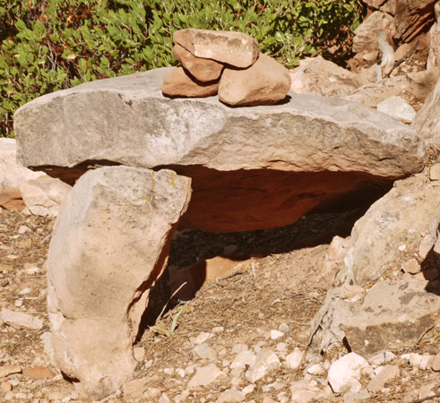
Cairn on Old Bright Angel Trail

Cairn on Old Bright Angel Trail |
|
|
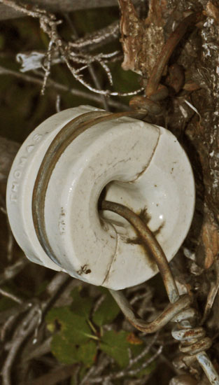
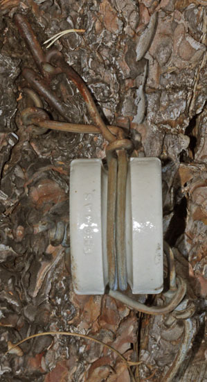
| I found this Thomas split insulator much higher on the north rim's Old Bright Angel Trail than the CCC type phone lines. This USFS type insulator is not installed in a USFS typical fashion; It is attached to the tree by two thick bent nails rather than a staple, and the line is tied twice (repaired?) to create a tension rather than run through configuration. There is about 10 feet of wire with mostly intact Galvanizing, then cut off square, attached. This was a steep area, where the run through configuration might cause all of the slack to run to the bottom of the hill. There may have been more artifacts nearby, but I had to watch my step, and may have missed others. | |
Sunday, September 8, 2019
Ken Patrick, Old Bright Angel, and North Kaibab Trails
I walked down the Old Bright Angel Trail, which was often overgrown with scratchy brush, and had many spots of unstable footing. I was not always able to find the old tread, and I missed dropping off the west side of one saddle while I followed decent tread down the ridge to a viewpoint. I found one old forest service type insulator in a downed tree, but installed in a non-standard way. Towards the bottom were CCC phone lines, but the construction details differed from those of the south side of the canyon.
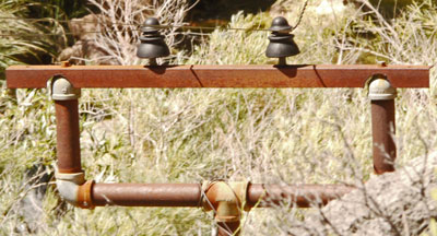
One Circuit, Plastic Insulators Branch towards Pump Station West of Old Bright Angel Trail |
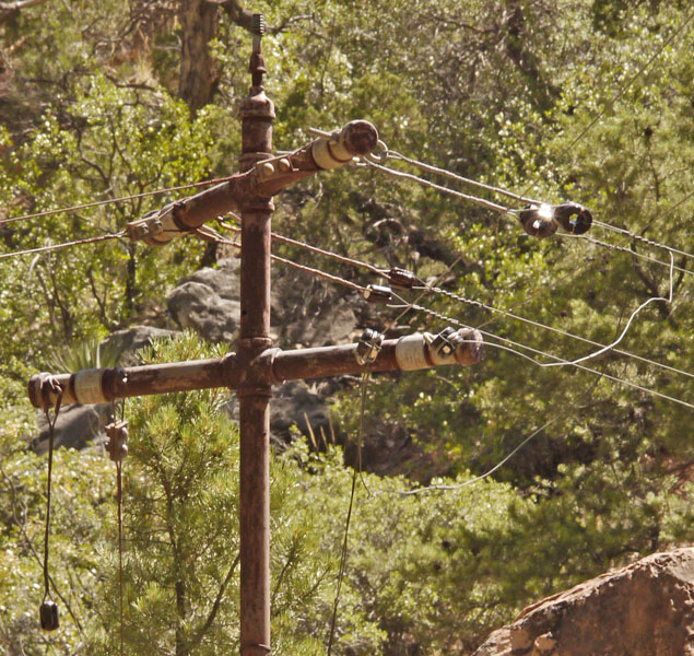
Turn in Line |
| Next pole southbound from above photo. East of trail. Photo from direction of above two black plastic insulator pole. Circuit inside turn uses USFS type insulators, where outside uses egg type. Several lines dangling, perhaps cut to clear trail. Note double tube twist splices, screw insulator mount on top. |
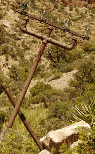
Broken CCC Pole, 3 Types of Insulators |
| Next pole southbound from Turn in Line photo above. East of trail. Photo from south. Pole broken and dangling from wires. Note the second line on the north side of the Grand Canyon was mounted on angle iron, different from south side of canyon. |
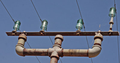
All Hemingray #9 Insulators Southbound from Broken Pole Above |
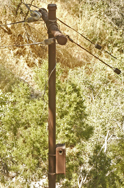
CCC Pole and Box Above Roaring Spring Pump Station End of this Branch |
Monday, September 9, 2019
I arrived at the south end of the Cape Royal Road at sunrise, then worked my way back up, walking around at all viewpoints to Point Imperial, including a few miles at Cape Final. I followed the same plan at the Nankoweap Trailhead and Marble Viewpoint adjacent to the Kaibab NF Saddle Mountain Wilderness. My only previous visit to the north rim was when I was hiking the Arizona Trail. I saw the views from Bright Angel Point, but not elsewhere. Though I've seen the maps many times, my appreciation of the geography of the Grand Canyon upstream of the Little Colorado River to Lee's Ferry improved radically after visiting all of these east and north facing viewpoints.
Tuesday, September 10, 2019
I walked around at Timp Point, but then took the day off. Gusty winds have stirred up dust, making views murky, and aggravating my allergies. A summer head cold and altitude complete a trifecta, making me breathe hard throughout this visit.
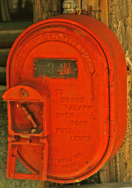
One of many Fire Telegraph Boxes Fire Alarm Telegraph Station To Sound Alarm Open Door Pull Lever (in box) Break Glass The Gamewell Co. Newton Mass |
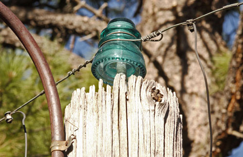
Pole Top Insulator |
| There were many old utility poles among the many historic log cabins of the North Rim Lodge. Among other utilities, these fire telegraph boxes were mounted on the poles at intervals of every few cabins. They were typically connected by these pole top insulators, but there were other insulator types; at least a couple of bracket mounted glass and a couple of USFS split type insulators, see below. The other side of the circuit was evidently ground. In spite of what the text on the boxes says, you actually twist the handle after breaking the glass door. This system has been disconnected and replaced by a modern fire alarm system. It is not a telephone. I documented it because its ground loop wiring is similar to the old phone systems I've been exploring. |
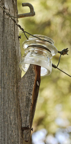
Bracket and Screw on Glass Insulator |
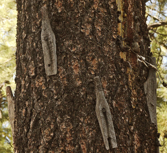
4 Brackets On One Tree |
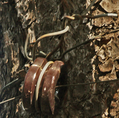
FS Type Split Insulator Note smaller conductor wire, and conductor near tree. |
Wednesday, September 11, 2019
I walked to Widforss Point, then drove to Point Sublime. The view there is 300° of canyon walls, and the roads would probably be better from the forest to the north than from the park. I saw a bison as I drove out of the park.
Thursday, September 12, 2019
The Jacob Lake Fire Tower had a few bits of old phone hardware. I drove up House Rock Valley Road 1065, stopping and walking various places. The Maze Rock Petroglyph Site was probably the best thing I visited. I headed back towards Flagstaff, touring Glen Canyon Dam and camping in the Coconino NF near Wupatki NM.
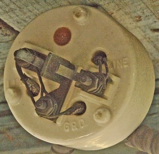
Front of Lightning Arrester |
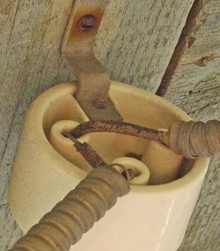
Back of Lightning Arrester |
| This twin line lightning arrester was mounted below the floor of the cabin of the Jacob Lake Lookout Tower. The left line on the front side is shorted to ground to make it function as a one line device. The two wires on the left screw terminal are to the cabin phone and down the tower leg. The gap between the center tab and the leaf spring looking contact is the gap the lightning jumps. Each armored cable carries two polymer and cloth insulated conductors jacketed in lead and then helically wound Galvanized steel. On the Back Side, The line to the left is to the cabin, the right side continues down a tower leg to the ground. | |
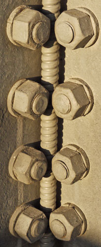
The Armored Cable is just Wedged Among the Hardware of the Tower Leg. |
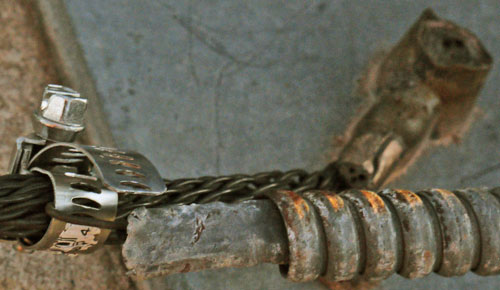
Line Bonded to Ground |
| One of the two wires in the cable is crudely bonded to the tower lightning ground; The other is broken just inside the cable. The lead shield is shown. The photo is at the bottom of the tower; the concrete foundation just shows at left. |
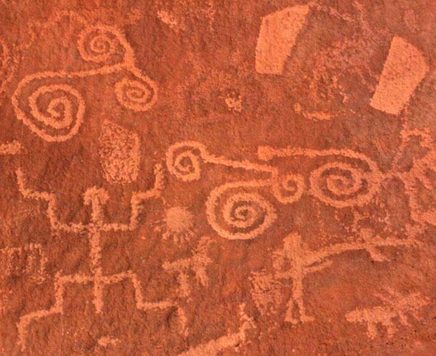
Maze Rock Petroglyphs |
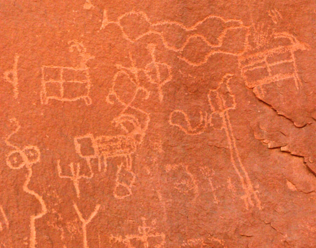
Maze Rock Petroglyphs |
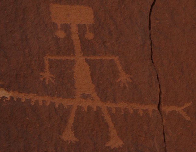
Maze Rock Petroglyphs |

Maze Rock Petroglyphs |
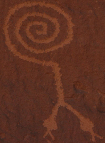
Maze Rock Petroglyphs |
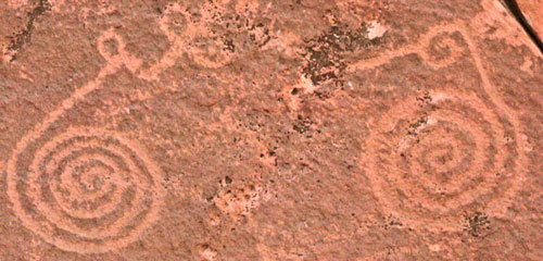
Maze Rock Petroglyphs |

|
|
I toured Glen Canyon Dam. Back in my Boeing days living in Washington State, I toured most of the dams on the Columbia River. Some had a Plexiglass tunnel, and you could walk through yourself, while others were guided, but I never paid and never waited long. I got on the $5 tour 45 minutes after arriving, and noted many guards with both pistols and assault rifles, and many clips for each. The Ground Fault below was the most interesting thing I saw. The winding cross section is about the width by length of my thumb.
Display Caption |

|
Friday, September 13, 2019
I edited photos, wrote, and loaded the website in Flagstaff. I've been emailing the Grand Canyon Archivist about historic documentation on the CCC phone line. I may visit the archive in early October. In Wupatki NM, I saw a herd of Pronghorn, and camped in the Coconino NF nearby.
Saturday, September 14, 2019
Navajo National Monument
I took the 5 mile Betatakin tour, and walked another 3 miles on the Sandal, Aspen, and Canyon View Trails. The Betatakin Cave is collapsing, so I couldn't walk among the ruins.
Sunday, September 15, 2019
Natural Bridges National Monument
I walked to the various viewpoints, plus Armstrong and White Canyons to Owachomo, Kachina, and Sipapu Bridges. I drove to the west of Monticello on North Creek Road FR174 through Manti - La Sal National Forest. The forest was lush with oak, pine, aspen and deer. Many hunters were out on ATVs. I visited the Newspaper Rock Petroglyph Site, with some excellent images. I camped in BLM land before the south entrance to Canyonlands National Park.
| Natural Bridges National Monument Hiking Distances (miles & feet) |
||||
|---|---|---|---|---|
| In Canyons / West Side | On Mesa / East Side | |||
| Trailhead to Sipapu Bridge | .6 | 500' | ||
| Sipapu to Kachina Bridges | 2.2 | Sipapu to Kachina Trailheads | 1.8 | |
| Trailhead to Kachina Bridge | .7 | 400' | ||
| Kachina to Owachomo Bridges | 2.2 | Kachina to Owachomo Trailheads | 2.2 | |
| Trailhead to Owachomo Bridge | .3 | 180' | ||
Bears Ears BLM National Monument
Bears Ears is part of the BLM lands south from the road into the Needles District of Canyonlands National Park to the Navajo Nation.
Monday, September 16, 2019
Canyonlands National Park
The Needles District
Though I paddled the Green River through with Judy and Jim, I've never before driven into Canyonlands National Park. I walked out to the Confluence Overlook, and could see the beach where Jim and I spent the last night of our kayak trip. Sure enough, the Green River looked green, the Colorado was beige-red with silt, and downstream the two sides of the river retained their colors to the end of my sight. Along the walk, I saw many tiny lizards, and a very slender 2' long Garter Snake. There were interesting tracks, including where a snake had to make extra moves to climb out of a two track rut. Birds? had carried piñon cones to shady spots and opened them there. I later walked a few short tourist trails: to Cave Spring, Pothole Point, and a pueblo style granary.
Tuesday, September 17, 2019
Canyonlands National Park
The Needles District
I walked from Elephant Hill Trailhead to Druid Arch, west via the Joint Trail, and around Chesler Park. The sinuous canyons, the arch, and the needles and mushroom capped towers were all excellent. I saw one other hiker on yesterday's walk, but this area was much more crowded.
Wednesday, September 18, 2019
Canyonlands National Park
The Needles District
I hiked to Peekaboo Spring via Big Springs, Squaw, and Lost Canyons. There were interesting pictographs and a stone that was used for grinding tools, perhaps.
Thursday, September 19, 2019
Canyonlands National Park
Island in the Sky
I walked to Grand View Point in plenty of time to watch the sunrise. After visits to Murphy Point and the Upheaval Dome overlooks, I decided I needed the rest of the day off, and camped north of the park. It was well before lunchtime, and I actually slept quite a bit. I hope my cold goes away soon. The Upheaval Dome may be an erupted salt dome or a meteorite impact site. Either way, it is a very impresive hole in the ground.
Friday, September 20, 2019
Arches National Park
Usually, when I drive into a national park before dawn, I have the place to myself for a while. One car after another was zooming into the park. I went to the very end of the road and found the trailhead ¾ full. I walked to the Dark Angel Tower, and when I returned, cars were parked off the parking lot everywhere. I found parking at all other viewpoints, but not many extra spaces. I walked most of the trails in Arches.
Saturday, September 21, 2019
Colorado National Monument
I drove the clifftop road above the steep sandstone canyons, visited the viewpoints, and took a few short strolls. I stopped to let a Bighorn Sheep cross the road. But this seems more like an urban hiking park for Fruita and Grand Junction, and I decided I'd rather spend most of my day at Gunnison...
Saturday, September 21, 2019
Black Canyon of the Gunnison
I drove west and east on the south rim, walking out to most viewpoints, and seeing the river, diversion tunnel, and reservoir dam.
Saturday, September 21, 2019
Curecante National Recreation Area
I visited some Denver and Rio Grande rail cars and drove along the reservoir.
Sunday, September 22, 2019
Great Sand Dunes National Park and Preserve
I saw some big elk, walked up the sand dunes, visited a few other spots and saw the visitor center.
Sunday, September 22, 2019
Capulin Volcano National Monument
The road to the top, and all rim trails, were closed. I walked a mile long trail.
Sunday, September 22, 2019
Fort Union National Monument
The park was closed to driving or even walking in. There were Santa Fe Trail pullouts on the access road for a distant view of the fort, and for not really visible wagon ruts. I saw many Pronghorn today.
Monday, September 23, 2019
Pecos National Historic Park
There are typical partially rebuilt Pueblo Indian ruins here, and there is a good museum with nice pots and ornaments. This is on trade and travel routes, and macaw feathers from Mexico, abalone shells from California, and shells from the Great Lakes have been found here. The Spanish used the same routes and built 4 mission churches here at various times. Americans built the Santa Fe Trail through here, and a Confederate invasion of the western states was stopped here in the Civil War.
I talked a while with a permanent crew who make and replace adobe tiles for the reconstructed ruins continuously. I traded my CDT elk story for this one: A rattlesnake had discovered a nest of a squirrel with babies too small to run. The mother started to carry the babies in her mouth one by one, kitten style, to a new hiding spot. She was jumping up onto the walls of the ruins and running along them, so the snake really couldn't follow her. But the snake found the new hideout with some of the babies. Just as the maintenace guy was about to loop the rattlsnake with a snake stick to relocate it, it struck one of the babies. Now the baby was shaking from the toxins, and tourists were gathering. There were many questions he would rather not have answered...
Monday, September 23, 2019
Petroglyphs National Monument
I walked 3 petroglyph trails, taking many pictures. I did not get to a volcano trail in the west of the monument.
Tuesday, September 24, 2019
Bandelier National Monument
I walked the main loop and the extension to Alcove House. These Pueblo ruins were against tuff cliffs, and storage niches were carved into the cliff walls. There were interesting petroglyphs and pictographs. Rectangular holes in kiva floors may have been drums. A ranger recommended a 16 mile day hike with field house ruins and an unexcavated pueblo. An extension off that hike reaches a cave with pictographs visible from the vally floor. A three day backpack would sample the best of the park's 70 miles of trails. An overnight hike should be in May or perhaps June to find water in creeks.
Tuesday, September 24, 2019
Manhatten Project National Historical Park
I did not visit this, but there is apparently enough open to the public for a day's visit. Sites within the lab grounds are not accessible to the public, but a museum and other historic buildings in the town can be visited.
Tuesday, September 24, 2019
Valles Caldera National Preserve
I drove the T shaped dirt road system. Other old roads will be developed into trails for hiking, biking, and horse riding. A few days would do justice to the trail system. Dispersed camping in cars or via backpacking may start soon, but at present, there is no camping. This is a large caldera with newer small volcanos and nice meadows and forests within. Ash from eruptions here affects the geology many hiking sites nearby, especially Bandelier and Kasha-Katuwe Tent Rocks National Monuments.
Tuesday, September 24, 2019
Kasha-Katuwe Tent Rocks National Monument
I picked up a great map for Kasha-Katuwe Tent Rocks NM, but did not visit. I need to hike this area on the next trip through. It looks like only 3.2 miles of hiking will visit some very interesting geology.
|
Following are several maps in a University of New Mexico Press High Desert Field Guides series about northern New Mexico. I bought the Valles Caldera and Kasha-Katuwe Tent Rocks ones because they are excellent, describing all needed hiking data and some excellent geological info. I should check them out and buy more if they are equally informative. They are not all about geology.
Valles Caldera National Preserve
All Trails Lead to Santa Fe
Rock Art Images of Northern New Mexico
Tony Hillerman's Landscapes
Roads to the Past
Kasha-Katuwe Tent Rocks National Monument
Dance Ceremonies of the Northern Rio Grande Pueblos |
Wednesday, Thursday, September 25-6, 2019
Chaco Culture National Historic Park
I hiked all of the trails open to the public. The main buildings, easily accessible by tourists, have excellent, beautiful stonework. As they were built in one project, there are not varying styles of masonry within one building. Outlying sites were less carefully constructed. There were endless interesting things to see. Many pictures to follow...
Friday, September 27, 2019
El Malpais National Monument
I visited 3 lava tubes in the Big Tubes Area. These were more interesting than a typical lava tube because of their tendency to collapse. Some tubes were long, big trenches with occasional bridges, while others had skylights occasionally. These tubes were larger in diameter than others I've visited, which contributes to their propensity to collapse, and leaves wide and deep trenches where collapsed. It's too late in the year for ice in the Ice Cave, but it holds ice stalagmites until well into summer. The trenches are big enough to hold a much wetter ecosystem than the surrounding plains, with moss and fern gardens particularly below skylights and also in shaded areas of trenches.
Saturday, September 28, 2019
El Malpais National Monument
I hiked the caldera loop. A nice conical volcano with a conical caldera is at the end. I also visited two more lava tubes, Xenolith and ?, which smelled much more fecund, probably because they are occasionally used by bats.
Saturday, September 28, 2019
El Morro National Monument
There were hundreds of inscriptions from pre Spanish Indians, and Spanish, Mexican, and American Explorers. A CCC trail, often cut into the sandstone, accesses views, Tinajas, and a pueblo atop the headland.
Sunday, September 29, 2019
Grand Canyon National Park
I saw a magnificent sunrise from Grandview Point, and walked out to ??, but this was basically a day of chores - Laundry, shower, and editing hundreds of photos from my visit to 19 National Park System Sites in the 4 corners states.
Monday, September 30, 2019
Grand Canyon National Park
I visited the park archivist and sorted through piles of documents all day, photographing (615 images) whatever good information I could find on old phone systems. I didn't quite get through the last item on the list, 64 file folders of administrative records of the CCC and that era. I read through folders 1-16, but need to start again at 17 on my next trip. I may find more documents I need, or I may need better photos if I messed up some. If my photos of black and white original pictures don't work out, I may need to re photograph them in better light, or obtain scans if available. There are some artifacts I would be able to see on a return trip.
| September 8 | Old Bright Angel Trail | 16 |
| September 9 | North Rim Grand Canyon | 6 |
| September 10 | Timp Point | 1 |
| September 11 | Widforss Point Trail | 10 |
| September 12 | House Rock Valley | 3 |
| September 14 | Navajo NM Betatakin | 8 |
| September 15 | Natural Bridges NM | 7 |
| September 16 | Canyonlands - Needles | 12 |
| September 17 | Elephant Druid Joint | 15 |
| September 18 | Lost, Peekaboo Trails | 15 |
| September 19 | Island in the Sky | 8 |
| September 20 | Arches NP |
Tuesday - Friday, October 1 - 4, 2019
San Diego
I visited Marie, Kate, Roy, and my mom. And a dentist, hearing aid specialist, and cornea surgeon with my mom. And Batiquitos Lagoon and the Pacific Ocean for exercise.
Saturday, October 5, 2019
Swap Meet Saturday
Gene and I shopped the Santee Electronics Swap Meet, Costco, Walmart, and the dollar store. Don joined us for lunch.
Sunday, October 6, 2019
Silver Strand Bike Path
Decades ago, I had visited the salt evaporation ponds in the south of San Diego Bay. They had just been converted to a wildlife refuge, and still had tide gates installed and operating. You could just walk around on the dikes. There was also a bike path along the Silver Strand, the narrow sand barrier island between the Pacific Ocean and San Diego Bay, which is actually the Tijuana River Delta swept north by the eddy behind Point Loma. Today I walked between Old Fort ? Road and the still operating salt works or I5. The southermost mile has a 6 foot tight weave chain link fence on both sides, and so is not very scenic. But at the freeway exit are two paths leading into the San Diego Bay National Wildlife Refuge, which might be worth visiting. The northern few miles bordered pickleweed mud flats and ditches with many birds. For the most part, you can't leave the bike path and walk on the dikes. North of Old Fort ? Road, the bike path enters the south Coronado housing, and becomes less interesting. The bike path sometimes follows the old tracks of the ?? Railroad. The tracks are still in place here and there.
Sunday - Wednesday, October 6 - 9, 2019
Amtrak Train: San Diego to Harrisburg Pennsylvania
| 1579 | Pacfic Surfliner | San Diego | Sunday, | October 6 | 1:30pm |
| Los Angeles | Sunday, | October 6 | 4:29pm | ||
| 4 | Southwest Chief | Los Angeles | Sunday, | October 6 | 6:00pm |
| Chicago | Tuesday, | October 8 | 2:50pm | ||
| 30 | Capitol Limited | Chicago | Tuesday, | October 8 | 6:40pm |
| Pittsburg | Wednesday, | October 9 | 5:05am | ||
| 42 | Pennsylvanian | Pittsburg | Wednesday, | October 9 | 7:30am |
| Harrisburg | Wednesday, | October 9 | 12:53pm |
Wednesday - Friday, October 9 - 11, 2019
Harrisburg, Pennsylvania
Tincup, Joy, Sale, John, and I went to the worlds largest Schmorgasbord for a prime rib and steak dinner. Thursday, we walked through an antique car show. There was much talking and catching up.
Friday - Saturday, October 11 - 12, 2019
Williamstown, Massachusetts
We arrived at the Appalachian Long Distance Hikers Association Gathering in time to register and attend the evening meeting. On Saturday, I spoke 4 times: With John on the maintenance of the Pinhoti Trail, on a panel on the Continental Divide Trail, on my hike of the Great Eastern Trail, and on Websites and Photography. This left me only two sessions free to listen: I enoyed one on coastal hiking in Portugal and one on medicinal and food uses of east coast plants.
Sunday, October 13, 2019
Keene, New Hampshire
John, Sale, Carrington, and I visited Rick G, discussing many national trail issues and personalities.
Monday, October 14, 2019
Drive to Pennsylvania
John, Sale, and I drove south on various scenic routes including the Taconic Parkway and Delaware Water Gap National Recreation Area. The autumn leaf colors were excellent through these areas and less so further south.
Tuesday, October 15, 2019
Drive to Abingdon, Virginia
We continued south on I81 and visited Tom and Kathy in Damascus. Damascus is the home of Trail Days and Abingdon of next year's ALDHA Gathering.
Wednesday, October 16, 2019
Leeds, Alabama
We arrived at John and Sale's home and attended sermons and servings at Mountain Brook Baptist Church.
Thursday, October 17, 2019
Pinhoti Trail, Alabama
John and I lopped the Pinhoti Trail between South Fork Choccolocco Creek and Rabbittown Road 55. We met Hayward, who blade cut the adjoining section south to FR540 and beyond. We parked on FR532-A: there is a 24" straddle blowdown 10 minutes north of this access point that would be easily cut with a big enough saw, wedges, etcetera. Otherwise, there are some blowdowns which are easily stepped over. Although I lopped out all trip hazards and branches near the face, a blade cutter would do wonders against leg brushing weeds. Roger recently string cut from 55 to Choccolocco; this area was nice. The tread is completely blown out, or very narrow, or pulled out by rootballs several places. A tread grubbing crew at some future date would be nice. I removed a breadbox sized bundle of trash from the Choccolocco Shelter; the broom is present but the bible and register are missing.
Friday, October 18, 2019
Pinhoti Trail, Alabama
I photographed the CCC Buildings on Flagg Mountain and talked with Nomblewill Nomad. Many thanks for his loan of a Pinhoti Survey book, a Flagg Mountain Master Plan, a Bob Pasquall CCC book, and a Flagg Mountain Register. John cleared south of road 56, but Marion and Emily had recently done the section.
Saturday, October 19, 2019
Leeds, Alabama
With all day rain, we stayed off the trail. I fixed Sale's chair elevator. A screw holding the rack had loosened, causing a motor over speed governor fault each time the pinion ran into the raised screw head. But it was a long troubleshooting process, fixing many small things and tightening many screws along the way. I also wrote much for this website.
Sunday, October 20, 2019
Pinhoti Trail, Alabama
John cleaned the trail to the North Dugger Shelter and replaced the register there. There were a few broken boards on the ends of the picnic table. I walked the Dugger Wilderness through to Pinky Burns Trailhead lopping and throwing sticks and logs off the trail. A second trip focusing on the center of this ten mile section could address many stepover blowdowns. A saw and ax would fix many of these.
Monday, October 21, 2019
Pinhoti Trail, Alabama
I lopped and cleaned debris from US431 south to the spur from FR515. John cleaned north and south from the spur. We visited the West Georgia Museum in Tallapoosa, where I took some pictures of old can openers.
Tuesday, October 22, 2019
Pinhoti Trail, Alabama
I worked from the Leafgate northbound to Blue Mountain Shelter and beyond up Baldrock Trail, where John was working. We replaced the log book in the shelter.
Wednesday, October 23, 2019
Pinhoti Trail, Alabama
I walked from the Terrapin Dam northbound to the Chief Ladiga Trail lopping and tossing sticks and logs off of the Pinhoti Trail. I replaced the log book in the Oakey Mountain Shelter. A big black lab dog followed me through and we drove him home afterwards. The neighbor said whenever he sees unfamiliar cars on the road he checks and usually sees this ultra friendly dog getting a ride back home. We went to homilies and hominy later.
Thursday, October 24, 2019
Pinhoti Trail, Alabama
John and I cleared north from FR500 and the Dugger Mountain Shelter. I was descending from the first hill when I ran out of gas for the chainsaw. As usual, the pine thicket on the northbound ascent from the shelter had many tangled blowdowns. I did not reach the dam and doubt I cleared two miles.
|
Pinhoti Trail 2004 - 2019 Trends
Pinhoti Trail Maintenance Status John and I have slowed down. There are no more overnight or all day work sessions. Typically, John works less than a half mile from a trail access point, clearing the area very thoroughly. I have him drop me 5-10 trail miles away, and I lop or lop and saw my way back to him. We're done by early afternoon.
Pinhoti Trail Shelters
Pinhoti Trail Workers and Clubs
Pinhoti Trail Extension Dreams
Pinhoti Trail Long Distance Hikers |
Friday, October 25, 2019
Leeds, Alabama
With heavy rain, we worked around the house and visited with Mary Sue, who was driving through from Texas.
Saturday, October 26, 2019
Leeds, Alabama
With more heavy rain predicted, we drove to Flagg Mountain and visited Nimblewill Nomad.
Sunday - Monday, October 27-8, 2019
Bus to Flagstaff
I boarded a bus in Birmingham at 2am and headed for Dallas. A bus to Amarillo was late getting started, and stopped because of smoking passengers, and a couple more times when a passenger whose speaker had gone missing began to shout at some sleeping children. Because of this, we missed our 2am connection to Flagstaff. I got very little sleep due to all of the interruptions. I got to Flagstaff at 10pm, and into a hotel room and asleep pretty quickly, but stayed exhausted through Tuesday.
Tuesday, October 29, 2019
Flagstaff, Train
I had planned to be in Flagstaff Monday afternoon and all day Tuesday to check mail, swap items from storage, write, etcetera. But fatigue from the bus trip caused me to do as little business and writing and as much resting as possible. I took the train to San Diego in the evening.
Wednesday, October 30, 2019
Train, San Diego
I arrived in San Diego and took the trolley to Spring Street Station. Many thanks to Gene who picked me up, stored my car, and gave advice and tools as I fixed a loose starter motor.
Thursday, October 31, 2019
San Diego
I walked on the Silver Strand bike path and in the Tijuana River Estuary. Later Jim L and I modified a weed cutter hub to take a standard 7½" circular saw blade, and tested Jim's fuel injectors.
Friday, November 1, 2019
San Diego
I looked at an old telephone pole line at San Elijo Lagoon, and later took my mom to a dentist, the blind center, a grocer, and to Marie's for dinner.
Saturday, November 2, 2019
San Diego
I went with Gene to the Santee Swap Meet. In early afternoon, we visted the Mission Dam and the new San Diego Mission on our way to spend some time with Don at Joan's place.
Sunday, November 3, 2019
March Field Air Museum
I spent a few hours seeing the airplanes and inside exhibits.
Sunday, November 3, 2019
San Gorgonio Mountains
I walked to Morton Peak Lookout 4,624'.
Monday, November 4, 2019
San Gorgonio Mountains
I walked the South Fork Trail 1e04 & 1e05 from Jenks Lake Road to Mine Shaft Saddle, and returning via the trail east of Dry Lake. There was flowing water in many springs and Dry Lake was full.
Tuesday, November 5, 2019
San Gorgonio Mountains
I hiked the Fish Creek Trail 1w07 from Fish Creek Meadows and 1n05 to the pass east of Mine Shaft Saddle, connecting with yesterday's hike. I saw prints of a small Mountain Lion. I then visited the horse camp at the head of North Fork Mission Creek. There was plenty of water flowing in the spring and the creek, way more than I've seen before. I also went to Coon Creek Cabin, meeting groups of southbound PCT hikers at both places.
A map of the San Gorgonio Wilderness might be a good addition to my book Public Land Survey System chapter since townships radiate north, south, east, and west from San Bernadino Peak. USFS trail and road numbers also reflect the PLSS numbers here, so the map would illustrate that fairly opaque subject. I placed the 1954 15' quad San Gorgonio Mountain on my desktop. It does not have trail numbers and is too detailed to be a web image. A San Bernardino National Forest Forest Order No: 12-18-01 VALLEY FIRE CLOSURE - 2018 map is also on my desktop and might be a nice web image - with some modifications. It seems better than the San Bernadino NF Map. 7½' Redlands includes the San Bernadino baseline west of here. In the northeast of that quad the baseline is shown in the forest, whereas further west Baseline Road continues through several cities, and across I210.
Wednesday, November 6, 2019
San Bernadino National Forest
I walked closed Highway 173 from north of Lake Arrowhead at the closure and Deep Creek Hot Springs Trailhead to the Mojave Forks PCT Trailhead. I walked to the Pinnacles, but they were too steep for me and were surrounded with Poodle Dog Bush. Finally, I visited Pilot Rock 5,260'. The view of the PCT terrain north and southbound was excellent.
Thursday, November 7, 2019
Twentynine Palms
I had been having trouble sleeping for a few nights, so I rested in a motel in 29 Palms, and did just a few chores.
Friday, November 8, 2019
Mojave National Preserve
Providence Mountains
I hiked to Amboy Crater and at Hidden Hill Mine.
Saturday, November 9, 2019
Mojave National Preserve
Providence Mountains
I walked at the Big Horn, Providence, and Vulcan Mines. At the Kelso Visitor Center I bought a hiking guide book with good background information and a detailed topo map for most interesting sites in the preserve:
Hiking the Mojave Desert Natural and Cultural Heritage of Mojave National Preserve
Michel DiGonnet
Sunday, November 10, 2019
Death Valley National Park
Black Mountains
I hiked Gold Valley, which is off Greenwater Valley Road via Lost Section Road. I parked at the pass, and took all left turns, visiting mine tunnels and can dumps on the southern spur road up a side canyon. I continued northwest down roads in Gold Valley, but returned cross country before completing the road loop. Later I drove to Dante's View, where one can see most of Death Valley to the north and south.
Monday, November 11, 2019
Death Valley National Park
Black Mountains
I drove to Furnace, Kunze and Greenwater before continuing to Furnace Creek to resupply and see the Visitor Center. The gas at Stovepipe Wells was a dollar/gallon cheaper than at Furnace Creek. Furnace Creek has bread, dairy, salad, and some fruit, but not at bargain prices. Stovepipe Wells has much less food. At the Furnace Creek Visitor Center I bought a hiking guide book:
Hiking Death Valley A Guide to its Natural Wonders and Mining Past
Michel DiGonnet
The same author wrote Hiking Western Death Valley National Park Panamint, Saline, and Eureka Valleys.
There is some overlap, so I left buying the second Death Valley book to another time. Including also his Mojave book, I think this author's local topo maps are excellent, as is the background information about each site. The books each lack a clear map of where each hike and chapter / zone is in relation to each entire park. Each book is an inch thick, I have done few of the suggested hikes, and it will be a long time before I finish...
In March 2019, two tracts of land were tranferred from the BLM to DVNP, the 6,369 acre Crater Mine lollipop in the north, and the 28,923 acre bowling alley, the strip of land that once separated DVNP and Fort Irwin including part of the Quail Mountains. Scotty's Castle and the entire associated road is closed for repair after an October 2015 flood; repair is expected by 2020. Of $46 million in damage, 1⁄3 will be paid from user fees, 1⁄3 from taxes, and 1⁄3 from highway funds. A trail at Father Crowley Vista is also closed. There are over 500 feral burros in the park and there is a control program.
Monday, November 11, 2019
Death Valley National Park
Panamint Range
I drove south along the West Side Road and west up to Trail Canyon. I parked at the top of the alluvial fan, and I hiked 3 miles up, short of the confluence, and short of all the mine sites
Tuesday, November 12, 2019
Death Valley National Park
Panamint Range
I walked up Hanaupah Canyon, following an old steep switchbacking road to mines at about 6000'.
Wednesday, November 13, 2019
Death Valley National Park
Panamint Range
I hiked up Johnson Canyon to Hungry Bill's Camp. The canyon narrows with flowing water were choked with scratchy brush. I often walked on the many parallel burro trials along the steep canyon sides.
Notes for a Future Burro / Horse Article
The Free Roaming Horse and Burro Act of 1971 protects feral horses and burros on BLM and USFS lands against capture, kill, and harrasment. There are herd management areas. Land management agencies can determine an appropriate herd size and capture excess animals for adoption, or sale for unadopted animals. In 2004, a rider to the Agriculture funding bill forbade spending on horse slaughter facilities, so meat can not be exported to Europe or elsewhere. The BLM estimates there are 88,000 feral equines on BLM and USFS lands; more live on military, NPS, Indian, and USFWS lands. The capacity of HMAs is about 27,000 animals, and BLM has 6-8,000 horses in corrals and 50,000 in leased pastures. Keeping a horse costs the BLM about $1.80/day; Horses and Burros cost the BLM $80 million and costs are rising. Horse populations double every 4-5 years.
Source: Sierra Club Desert Report September 2019 John Hiatt Wild Horses and Burros A Most Contentious Issue
There is a lot of burro damage and sign in Death Valley NP. China Lake publicity discusses burro problems. I saw some burro sign in Mojave. There is a burro facility near Ridgecrest. It would be easy to get photos of a thorough selection of burro damage and sign on some future Death Valley trip. Similarly, horse evidence could be easily photographed north of Rawlins, Wyoming on some future road trip. I may have photos from past Cumberland Island trips, or from hikes on the CDT.
Thursday, November 14, 2019
Death Valley National Park
Panamint Range
I drove up Warm Spring Canyon and walked to the Panamint Mine, Grantham Mine, and several Warm Springs Mines (all Talc mines). Later I hiked to Arrastre Spring, where Death Valley was named by a wagon train.
Friday, November 15, 2019
Death Valley National Park
Panamint Range
I hiked to the Gold Hill Red Eagle and Bullet Mines, the mines and cabins in Butte Valley, and the Pink Elephant Mine.
Saturday, November 16, 2019
Death Valley National Park
Grapevine Mountains
I resupplied at Furnace Creek and drove the Titus Canyon Road to Leadville and Klare Spring.
Sunday, November 17, 2019
Death Valley National Park
Panamint Range
I visited the Wildrose Charcoal Kilns before hiking to Telescope Peak (11,049') and Rogers Peak (9994', Antenna Farm). Telescope Peak has a view beyond the eastern escarpment of the Sierra Nevada to the Kaweah Range, and to the salt flats in Owen's Valley, to the ranges east of Los Angeles, and east several basins and ranges. The view was quite hazy, so perhaps more could be seen on a clear day. I met three guys involved in a project to collect DNA from as many redwood and sequoia groves as possible, and do some massive genetic database analysis. I should look up the Redwood Genome Project and Neal Lab. Years ago, Jim and I hiked from near the Charcoal Kilns to today's Mahogany Flat Campground and Trailhead 8133', where I am camped. The road was so bad we debated whether a 4WD truck could have made it, but a compact sedan would be fine today. On another trip, I walked through quite a bit of snow to get to the Charcoal Kilns.
Monday, November 18, 2019
Death Valley National Park
Panamint Range
I hiked to Wildrose Peak (?') and visited the 23 Skidoo gold mining distract.
Tuesday, November 19, 2019
Ridgecrest, California
After many days in the desert, this day of rest, showering, laundering, and resupplying was much appreciated. I visited the Maturango Museum and the China Lake Weapons Museum. The Maturango Museum has many great exhibits, especialy outside, of the most interesting things that disappear from old mine sites. Jim and I visited the China Lake Museum many years ago when it was on the base. It was a building chock full of cross sectioned weapons and other interesting stuff. The new, off base version has much less stuff and is not the outstanding destination that I remember.
Wednesday, November 20, 2019
Barstow, California
With reasonably heavy occasional rainstorms in the morning, and with the rain predicted to remain sometimes heavy until 3am tonight, and taper off through early afternoon tomorrow, I elected to drive on to Barstow and check into a motel again. There is a vast backlog of website writing and editing tasks to do to entertain myself while I avoid slimy desert mud and floods.
Thursday, November 21, 2019
Mojave National Preserve
Granite Mountains
I arrived in the Willow Spring Basin Before noon, and completed a counter clockwise loop up to Willow Spring, west across many minor washes, down a major drainage, and east to my camp. Willow Spring was flowing well, but I lost patience with scratchy bushes and decomposing granite boulders before reaching higher springs. I then made a clockwise loop along a washed out and overgrowing eastbound road, southwest into the Sheep Corral to a low fork, and northwest out of the drainage towards my car.
Friday, November 22, 2019
Mojave National Preserve
1942 Telephone Line
I explored a 1942 telephone line with hundreds of poles. South of Van Winkle Spring Road, it seems to be buried. However, the pole line is not terminated with a guy and anchor, so it must have continued south. Poles or holes are not present. It is on poles with 2 pairs of bare copper coated iron wire north to Granite Pass, with 3 pairs continuing north. In the pass there is a box hooked to the two southbound pairs, but there are 3 twisted pairs down the pole and 3 devices in the box. The third pair crosses the road to a telco style microwave facility. At Kelso Dune Road there are 4 pairs. 1¼ miles northeast of the Kelso Depot, the line crosses the paved road and heads due north on a dirt road. After a half dozen poles, the poles are cut down hip high to beyond my vision. The wires are tied diagonally down to one pole in a crude guy line configuration. A spur line once provided phone service to the depot, but it is in terrible shape, with many wires down.
A ranger (PG) told me the line was installed before WWII as an early warning system (but the poles are marked 1942, early war?). His best source of information was a technical report perhaps a dozen pages long. It was written when the line was in use, not by a current historian (Army? Phone Co? Railroads? Kaiser Vulcan Mine?). He had last perused the report a few months ago, but could not find it (might be with a biologist?). The line may have exited the Preserve near Halloran Summit in the north, and in the south may have continued southeast to the railroad and US66 towns of Danby, Essex, or etcetera.
It occurred to me to make up a data sheet and walk the entire line sometime. Each pole was marked for type 4, 30', 1942 installion, and had a serial number on a 1" galvanized steel tape (sometimes also a second number starting with J), though many date nails and serial numbers were missing. A kit for observing old phone lines might include a magnet (to see if a wire is iron below copper or zinc), a caliper (wire guage, doodad dimensions), tape measure or laser (doodad dimensions, pole height and spacing), the camera, the GPS, the data sheets, etcetera.
Pole Nails Internet Search and Guessing
At the top is a 'Code Nail' 4, which specifies the wood type, treatment, etcetera. At the lower left is the 'Height Nail' specifying pole height in 5' increments, 30' in the Mojave. At the lower right is the Date Nail; 42 specifies 1942 in the Mojave. I saved some internet PDF Documents. Woodpecker damage to wood poles is the most significant cause of pole deterioration in the U.S.
Friday, November 22, 2019
Mojave National Preserve
Granite Mountains
Reference: MD353
I hiked up Silver Peak 6,370'. The view was excellent, encompassing perhaps half of the preserve. I briefy visited Coyote Spring. Two old concrete hip high tanks had been deliberately breached. The road comes within yards, so there was shooting debris and other trash about. There were some all steel church key opened beer cans and other old cans, but I felt they were probably brought from other places by modern tourists.
Saturday, November 23, 2019
Mojave National Preserve
Granite Mountains
Reference: MD353, 365
I walked the old road to the El Compache / Comanche / Christopher Mine, returning via the creekbed and some ridges north of the road. I later hiked up Bull Canyon until I was in continuously dense, scratchy brush.
Sunday, November 24, 2019
Mojave National Preserve
Providence Mountains
Reference: MD315
I walked the Quail Spring Trail across the Providence Range to the area of Hidden Hill. Someone had driven from near Hidden Hill to the pass, deep in the wilderness. A better map of the Hidden Hill area might reveal old roads and more mine sites, making a cross country hike interesting.
Monday, November 25, 2019
Mojave National Preserve
Providence Mountains
Reference: MD309
I walked around the open pit of the Vulcan Mine, and to the top of a hill to the east. The weather was cold but clear and calm. I then headed for San Diego. Halfway to Barstow, a big windstorm started, complete with enough sandstorming to lightly frost the windshied and occasionally produce whiteout conditions. I hit one tumbleweed. Some thick telephone cables were galloping in second mode. The Montero was jerking out of lane, requiring lots of steering correction. I was pretty frazzled by the time I got to Victorville, and stopped to shopped at Costco mostly to relax, but Thanksgiving shopping madness had started. I continued in sandstorms and traffic to San Diego, just missing dinner.
Tuesday, November 26, 2019
San Diego
Los Batiquitos Lagoon
I walked Puff Doggy half way along the Lagoon Trail. The tide was high, and one Great Egret was hunting fairly close to the trail. I visited Mom, finding or fixing various things. Her new hearing aid seems to need adjustment. When it was new, we could talk at a normal volume, and even amongst some noise, but now we are talking loudly to be understood once again.
Wednesday, November 27, 2019
San Diego
I walked the length of the Batiquitos Lagoon Trail before the day's rain began. Then I checked other access to the lagoon. Starting from the east end of the trail, and walking clockwise around the lagoon, there are good sidewalks along Batiquitos Drive (.4 miles), Aviara Parkway (.8 miles), and El Camino Real (.5 miles), to Arenal Road, but there are few views of the lagoon. There are gates limiting access to some neighborhood street shortcuts. At Arenal Road, in the northeast corner of the lagoon, there is a short trail system that is overgrown and muddy, but has a nice view of the east end of the lagoon. Continuing south on busy 4 lane El Camino Real (.7 miles), there is a bike lane but usually not a sidewalk and usually not a clear veiw of the lagoon. Continuing west on busy 4 lane La Costa Avenue (1.8 miles), there is a bike lane and a nice sidewalk but usually not a clear view of the lagoon. Still, the sun would be behind you, making whatever views you found better for photography or observation due to the lower glare. At the southwest corner is La Costa Avenue Park and Ride Lot with picnic tables, but with a tall chain link fence blocking views and access to the lagoon. Here, the freeway bridge will not allow a loop back to the west end of the trail. West of the I5 freeway there is little access, save for the Batiquitos Lagoon mouth at the beach, and maybe a viewpoint at Stern Way.
| 6000 BC | Earliest Indian Sites at Batiquitos |
|---|---|
| 300 BC- 1800 AD |
Many Kumeyaay Sites |
| 1769 | First Spanish Explorers - Batiquitos Means Little Watering Hole |
| El Camino Real | |
| 1870s | American Homesteading |
| 1881 | California Southern Railroad |
| 1912 | Pacific Coast Highway |
| 1952 | San Marcos Dam |
| 1965 | Interstate 5 |
| 1994 AD | Major Restoration Opened Inlet to Ocean |
West to East Parking Areas
There is street parking and access to the west end of the trail near the Batiquitos Lagoon Nature Center, 7380 Gabbiano Lane or at Piovana Court. There is a parking lot at Pelican Way and Batiquitos Drive. Continuing east, there is a parking lot at Golden Star Lane and Batiquitos Drive, parking at the Aviara Golf Course and Restaurant, and street parking at Spoonbill Lane and Batiquitos Drive.
| Batiquitos Lagoon Trail Mileage | ||
|---|---|---|
| Gabbiano Nature Center | Trail to Pelican Lot | .28 |
| Trail to Pelican Lot | Golden Star Lane Lot | .45 |
| Golden Star Lane Lot | Aviara Golf Course | .37 |
| Golf Course | Spoonbill and Batiquitos | .56 |
| Gabbiano Nature Center | Spoonbill and Batiquitos | 1.66 |
Thursday, November 28, 2019
San Diego
Mom, Julie, Marie, Roy, Katie, and I attended the extended family Thanksgiving at cousin Tammy's place. Many kids have grown to college age and were interesting to talk with.
Friday, November 29, 2019
San Diego
Gene and I fixed a few Montero issues, including a new odometer / speedometer cable and replacing the PCV valve. Both were fairly inaccessible to my big hands. The next day, after a clicking sound with a rate proportionate to speed didn't resolve, I removed the connector behind the speedometer and found the cable had bent rather than sliding into the square socket. I straightened the cable, reassembled the connection, and all was well. On December 3, I replaced the battery after the engine just stopped for a few moments in Williams and later I needed a jump start in Flagstaff.
Saturday, November 30, 2019
Mojave Desert
I left Carlsbad mid morning. There was snow on the hills to both sides of I15 even within San Diego County. From the bottom of the Cajon Grade at the I15 / I215 split onwards, there was often plenty of snow by the roadside. I saw a few scattered old utility poles northwest of Halloran Spring, none at Halloran Summit, but a line of old poles just south of ?. The crossarms and old wire were gone, with just a modern communications cable installed.
Sunday, December 1, 2019
Lake Mead National Recreation Area
I looked around various places, and visited Hoover Dam. I walked westbound on the Rail Trail.
Monday, December 2, 2019
Lake Mead National Recreation Area
I walked eastbound on the rail trail, then to Liberty Arch and a viewpoint, and to Arizona Hot Springs. Dispersed car camping is very popular here. Toilets are even installed at popular areas. A rodent woke me, apparently quite busy under the hood, a few times, but left when the car swayed as I woke.
Tuesday, December 3, 2019
I drove from Lake Mead National Recreation Area to Flagstaff, and did errands to prepare for a road trip to Big Bend, where I will meet friends on December 11. I stopped briefly in Williams to photograph some interesting stuff in their city visitor center / USFS visitor center.
Tuesday, December 3, 2019
Montero Electrical Issue
In Williams Arizona the engine just stopped running as I was driving around downtown. After a few noiseless tries, the engine started back up. In Flagstaff, the battery was too weak to start the engine, but a jump got me going. The battery was about 8 years old, its warranty life. Over the last few months, starting the engine occasionally sounded sluggish. There was mixed snow and rain, not great conditions for diagnosing and fixing cars. I bought a new battery. Per the manual, a warning light would illuminate if the car was not charging. As there was no light, I assumed the problem was fixed. Night was coming, so I got a motel room and gave up for the day.
Wednesday, December 4, 2019
Montero Electrical Issue
I swapped things between storage and my car for a trip to Big Bend National Park and retrieved my mail. I was ready to leave for Texas, but I was nervous about the electrical system. Then it occurred to me I could check the battery voltage through the cigarette lighter - out of the snow. Engine running or not, headlights on or off, the Voltage was between 11.2 and 11.67 Volts. An open circuit battery ought to have 12+V and a battery on charge ought to have 14+V... Clearly, there was no charging happening. Like it or not, I needed to replace the alternator in the snow. At the auto parts store, a $700 charging system analyzer could not complete a test because of excessive electrical noise. A new likely diagosis is that an intermittent connection in the alternator now causing noise has occasionally and increasingly prevented battery charging. This alternator does not have externally replaceable components. I spent a lot of time at Napa trying to find an alternator close to me, but two days away in San Diego or Denver was the best I could do. I got a motel for 2 more nights... I had the new battery charged with the following results: 13.2 Volts, 702 Cold Cranking Amperes of 750 rated. I also bought a new v belt, a new multi groove belt and a new lead + battery terminal. The old lead terminal and nut were both so chewed up it wasn't possible to get a truly tight connection. The belts looked fine but were of unknown age. Another v belt for the air conditioning has been missing long enough that the pulleys are unpolished or dusty. I decided I probably don't care about AC and didn't buy a replacement. But if I have to stay in the desert some summer, maybe I can fix that system... I also decided that since I was eating up the week I have to explore other parks on the way to Big Bend, I should plan to extend the trip and explore on the way back. So I began a few day process of organizing finances.
Thursday, December 5, 2019
I hadn't slept well in the motel for the last couple of nights, so I wasn't really able to write. I accomplished little.
Friday, December 6, 2019
The alternator came in early enough for me to install it. I started before 1pm and had plenty of time left over at the end of the day. It was not easy to move the power steering pump to install and tension the v belt. I will probably have to retension it, but it seems fine now. I blew a 100 Amp fuse on the positive terminal of the battery, but I was easily able to replace it as I was working in the parking lot of the auto parts store. I found a shredded v belt while fishing for a dropped nut - probably the missing air conditioning belt. The charge voltage with the new alternator was over 14 Volts - success. The old multi groove serpentine and power steering v belts really showed their age; I was glad to have new ones.
Saturday - Monday, December 7 - 9, 2019
On Wednesday I realized that the delay and expense of the charging issue meant that I should get more money now and travel more after the Big Bend meetup. The check should have entered the mail Thursday, but with the Christmas mail volume, I had to wait an unknown number of days to get it. I camped in the Coconino NF near Sunset Crater NM. The were a few inches of snow, but I found bare patches in a nice campsite just east of the monument. On Monday, I tried camping east of the mailboxes and the Strawberry Wilderness, which is considerably lower and perhaps warmer.
Monday, December 9, 2019
Montero Starter
The Montero would not crank after several tries. I got under the car and felt the starter motor. The high current wire was tightly attached to the stud but the stud floated a little in the axes perpendicular to the stud. The car started after this jiggling.
Tuesday, December 10, 2019
Montero Starter
I found my check at the post office and was ready to head for Big Bend! I went outside and yesterday's no start issue recurred. The dash lights illuminated as normal, and there were some relay clicks, but no cranking. No amount of jiggling helped. I was in a 15 minute parking zone! Fortunately, various people offered to help, and soon the car was pushed across the street to a pay parking spot. I paid $3 for 3 hours and got a ride from one of the generous people to the parts store. I ordered a rebuilt started overnight from Phoenix. I had the car towed for $75 to a hotel. I think this is the only time I've ever called for a tow.
Wednesday, December 11, 2019
Montero Starter
I picked up the starter at 7am. It was still dark and there was a thick layer of frost, but I had dry asphalt to work on. I went back to the store for new cap screws when the old ones did not thread freely. I was done before 10, and showered and out of the motel by 11.
Wednesday, December 11, 2019
Flagstaff to Big Bend National Park
I drove east on I40, US180, and US60, then south on I25, finally moteling in Truth or Consequences. To New Mexico, I more or less followed the Little Colorado River. I passed through Pie Town, the Very Large Array, and other landmarks from my CDT and GET hikes. New Mexico's sunset did not disappoint. Colorful clouds were at every point of the compass, and a nearly full moon rose behind a few thin strips of black cloud.
Pole Lines
I40 mile 219: west on the north frontage road in Coconino NF?, east on the south in private?
East of Winslow north frontage
US180 311 Little Colorado - 317 Building
Thursday, December 12, 2019
Flagstaff to Big Bend National Park
Kilbourne's Hole, New Mexico
I visited Hunt and Kilbourne Holes. These miles wide holes were left after volcanic eruptions so violent that no lava or debris collected nearby. Berms line parts of the rims, perhaps where the earth's surface lifted up to let the erupting steam out. The dirt roads were mostly good and easy to travel, but there were several long slimy mud bogs.
Thursday, December 12, 2019
Flagstaff to Big Bend National Park
There is an active missions trail in El Paso, Texas.
Thursday, December 12, 2019
Flagstaff to Big Bend National Park
Van Horn Phone Lines
I found stretches of old phone line on various types of poles, and with 7⁄64' or 15⁄64' copper over iron wire.
Thursday, December 12, 2019
Big Bend National Park
I camped at Rio Grande Village near Dan and Sherrie, John, George and Angie. There was nice talking with Dan and Sherrie, but I found out Marion C had died.
Friday, December 13, 2019
Big Bend National Park
George, Angie, John and I walked the Chimneys Trail, seeing petroglyphs, pictographs, mortars, flakes, hollowed overhangs, and etcetera at the chimneys. We visited most sites southwest along the road to Santa Elena, but had just a little time at each place.
Friday, December 13, 2019
Montero Radiator Hose Clog
John noticed the radiator upper main hose was collapsing under vacuum. I found that the vertical draw tube in the plastic overflow tank was clogged with a clay mud. I cleaned both the tube and the tank, repeating the cleaning the next day, and removing a lot of mud from the system. For the next few days, I found that the radiator was remaining full and the tank was functioning correctly. The temperature guage in the truck has never read even near high, though the clog must have been there long term.
Saturday, December 14, 2019
Big Bend National Park
John and I drove west along River Road East, a reasonable dirt road, to Mariscal Mine. There we spent a couple of hours exploring the mine tunnels and various mercury refineries. We took the Black Gap Road north, which turned out to be a 4WD extravaganza. We also enjoyed the interpretive trail at Dugout Wells.
Sunday, December 15, 2019
Big Bend National Park
The six of us hiked the Balanced Rock Trail. I saw a Walking Stick Bug. We had lunch at the Chisos Basin restaurant and walked the short Window View Loop. John and I participated in a focus group at the Panther Junction Visitor Center. We each earned $60, which we will donate to Flagg Mountain.
Monday, December 16, 2019
Big Bend National Park
George and Angie headed for home, and the rest of us moved to the Cottonwood Campground. John and I watched the park movie and I got a permit for the rest of my stay. My backcountry sites were free, but the permit was $12. One can stay in the park for 2 weeks at a time, two weeks maximum in the busy spring season, and 30 days total per year. We walked the Santa Elena Canyon Trail and Dorgan-Sublett Trail.
| Campsites / Permit | ||
|---|---|---|
| December 17 | Juniper Flat 1 | JF1 |
| December 18 | Grapevine Hills 4 | GH4 |
| December 19 | Grapevine Hills 4 | GH4 |
| December 20 | Paint Gap 3 | PG3 |
| December 21 | Telephone Canyon 1 | TC1 |
| December 22 | Telephone Canyon 1 | TC1 |
| December 23 | Camp de Leon | CL1 |
| December 24 | Camp de Leon | CL1 |
| December 25 | Terlingua Ab 1 | TA1 |
| December 26 | Terlingua Ab 1 | TA1 |
Tuesday, December 17, 2019
Big Bend National Park
John shuttled me so I could walk from Chisos Basin west to The Window, Oak Springs, Cattail Falls, and Sam Nail Ranch. I misplaced my wallet and spent the rest of the day ransacking my car and reporting it lost. I camped at Juniper Flats, just 10 minutes walk from Chisos Basin. It was frosty and chatting night hikers woke me many times. The visibility of the stars was outstanding.
Wednesday, December 18, 2019
Big Bend National Park
I watched two woodpeckers working at the tops of power poles in the gathering light of dawn. After another few hours searching every bag, pocket, and corner, I found my wallet. I was not able to call on the strange roaming cell tower in the park, and my LeEco phone failed endlessly for GBoard, so I couldn't send email either. I hiked Ward Spring Trail and Upper Burro Mesa Pouroff Trail. Both were nice, and I saw only 3 other hikers between the two trails.
Thursday, December 19, 2019
Big Bend National Park
I walked a counterclockwise loop of the Chisos Range, including Laguna Meadows, South Rim, and Emory Peak. I started well before dawn but there was enough moon and star light to see rocks, roots, and steps even in tree shadows. Views were fairly hazy. There was lots of water in Boot Creek and Boot Spring.
Friday, December 20, 2019
Big Bend National Park
I visited Apache Canyon, with a pretty pastel cliff and another bright red and orange cliff. Along the way I saw an old ranch with a dirt tank, a stone corral in excellent condition and a stone house with fairly intact walls. Nearby was a flint quarry with many flakes and waste chunks, an excavated pit, and pictographs. I saw a metate and a mortero, and an old glass bottle. To the west was another neat canyon.
Later I visited an old ranch with a corral, windmill, and stone house at Dripping Spring.
Friday, December 20, 2019
Montero Door Latches
For some time the inside handles of the rear passenger doors have not been opening the doors. For the driver side rear passenger door, even the outside handle did not always work. The back door often took 5 or 10 handle pulls before it would open. This was all a bit of a nuisance, especially when I wanted to get out in the night, or when it looked like I was breaking into my car in parking lots. In previous attempts at fixing the locks and latches I disconnected the automatic locks and adjusted the length of the linkages from the inside handles to the latches. Each repair worked for a while... Today I used up a whole can of brake cleaner flushing all 5 latches and then working the mechanisms repeatedly. For the rear passenger doors I removed the inside panel so I could get to more parts of the latch mechanism. Just flushing the dried grease and dust from the latches worked wonders. All latches worked freely. I also cleaned the five leashes that keep the doors from opening too far. I lubricated all the latches, leashes, and hinges with spray carrier white litium grease. Everything seems to work better and there are fewer squeaks. The key cylinders have always worked fine and I did nothing to them.
Saturday, December 21, 2019
Big Bend National Park
I returned to the fossil exhibit so I could ponder the exhibits at length. I visited all other roadside interpretive sites to the north entrance. I walked through Dog Canyon and to Devil's Den. Finally, I drove southbound on Dagger Flat Road and Old Ore Road to my camp at Telephone Canyon.
Sunday, December 22, 2019
Big Bend National Park
I walked a few hours in on Telephone Canyon Trail. Eventually, the trail was overgrown and I wished I had nice topo maps for the area so I could either follow close by or walk to whatever feature the map suggested. The park wide NGTI map just dosen't have enough detail for plain old wandering. I was told there is a mine camp not far up the old road past the campsites.
Monday, December 23, 2019
Big Bend National Park
I walked up Ernst Tinaja, a very pretty canyon. Then I walked to the northern terminal of the aerial ore tramway from Camp de Leon. There were fading roads most of the way, but there was cross country walking where the overgrowth was too dense. The bull wheel was there but broken, and the cables are where they fell. The structure of large timbers is collapsed. There were small piles of coal and ore.
Tuesday, December 24, 2019
Big Bend National Park
I walked the Boquilla Canyon and Ore Terminal Trails, and visited the Hot Springs. I also fixed software issues with both my handheld and laptop computers so I could email and upload the website.
Wednesday, December 25, 2019
Big Bend National Park
I was the first to arrive at the Lost Mine Trail and had it to myself on the way up. Descending, though, I had to encourage many people to keep at it... I bought a couple of books to increase my knowledge of Big Bend for some future trip. I want to return with detailed topo maps of interesting places and wander cross country. At the restaurant the only coice was an all you can eat Christmas buffet of salad bar, roast beef, ham, turkey, all the sides, and a dozen kinds of desert. I suffered through it as best I could. In the afternoon, I walked the Lower Burro Mesa Pouroff, Burro Springs, and Tuff Canyon Trails.
Thursday, December 26, 2019
Big Bend National Park
I walked from ? Road eastbound on the Chimney Trail to the Chimney, then wandered back cross country, visiting many canyons with fascinating rocks and geology.
Friday, December 27, 2019
Big Bend Ranch State Park
Museum of the Big Bend
Fort Davis NHS
I drove west from Big Bend National Park through Big Bend Ranch State Park. Between the two parks there are excellent interpretive signs. The state park sells a good plastic topo map for $8. Internal capsites need to be reserved online in popular seasons.
I visited the Museum of the Big Bend at ? University. Most interesting was an excellent collection of historic maps of Mexico.
There was just enough time left in the day to make a hurried visit to the buildings with displays at Fort Davis NHS. More time and a lot of reading on the history of the site would make a more interesting visit.
I drove west into an excellent sunset, and motelled in Van Horn. There was no laundry machine in the motel, and the local laundromat just went bankrupt. It's been 2 weeks since laundry and shower... At least the shower was a great pleasure.
Saturday, December 28, 2019
Guadeloupe Mountains National Park?
There may be snow and high winds through the day and into the night, but it will be sunny starting tomorrow. I decided to head north rather than sitting around in town.
|
Website Writing Projects Backlog
Photos and Research
Distribute Journals into States, Parks, Etcetera
Cans
Telephones
Pinhoti CCC
Pinhoti Shelters
Pinhoti Plan
John's Pinhoti
Mapping |
Kilbourne Hole Volcanic Crater
Kilbourne Hole is a Maar, a volcanic crater with little solid ejecta. It is between 24,000 and 100,000 years old, is 1.7 miles long by over 2.1 miles across, and is 443 feet deep. The bombs are weathered brown or black on the outside, but are green olivine inside. Hunt's Hole is the same type of crater a couple of miles further south. Potrillo Maar is further south right on the international border.
Quoated From BLM website:
Latitude, Longitude 31.97013444, -106.95
Directions to Hunt's Hole and the north side of Kilbourne:
Take I-10 to Texas Exit 2, and turn left at Gadsen High School to start on NM-28. Continue on this road for about 4 miles (6.4K). Turn right at Mercantil Ave./NM-182. Continue for about 1 mile. At the first intersection, turn right at Alvarez St. (the Union Mercantile store is one the corner). Continue for about half a mile. Stay left at the fork. Continue on Co. Rd. A020 for about 7.8 miles. Turn right on Co Rd A012. Continue for about 3 miles. Turn left on Co Rd. A011. Continue for about 8 miles. Turn slightly to the left onto Co Rd. A013. Continue for about 3 miles, or until you can see the hole. To get to Kilborne Hole: Make a U-turn and return the way you came on Co. Rd. A013. After about 4.5 miles, you will come to the edge of Kilbourne Hole. You will need to park your car just outside a gate and hike in over the edge.
Directions to the south side of Kilbourne Hole: Take Interstate 10 exit 155 (Vado Drive). Turn right, or head west to the stop sign at NM Highway 478. Turn left. After approximately 0.2 miles, turn right on NM Highway 189 and travel approximately 1.1 miles. Turn left on NM Highway 28. Continue south for approximately 2 miles. Turn right on W. Afton Road, and drive approximately 11.2 miles. Turn left on Douglas Munro Road, and drive approximately 6.5 miles. Turn left at the "T" in the roadway, drive approximately 0.2 miles, and cross the railroad tracks. Turn left on Co Rd A017, and drive approximately 7.2 miles. Turn right on Co Rd A011. Drive approximately 8.1 miles to the crater.
I placed USGS 7½' KILBOURNE HOLE, NM 2017 on my desktop. I should print the topography and roads, and separately the photographic image.
Sites to Visit on Trip to Big Bend
El Malpais Cebolla Canyon Ruins and Petroglyphs
Petroglyph NM Volcanic Area
Kasha-Katuwe Tent Rocks National Monument
Salinas Pueblo Missions National Monument
San Lorenzo Canyon / U.S. Fish and Wildlife Service / Bureau of Land Management
Three Rivers Petroglyph Site
White Sands National Monument
Living Desert Zoo and Gardens State Park
Carlsbad Caverns National Park
Guadalupe Mountains National Park
McDonald Observatory
Big Bend Ranch State Park
Big Bend National Park
Kilbournes Hole
Chiricahua National Monument
San Pedro Riparian National Conservation Area
Las Cienegas National Conservation Area
Gila Box Riparian National Conservation Area
To Look Up Later
Navajo Power Station
Sticky Door Locks
Great Western Trail
Driver Window Switch
Train and Plane - Birmingham to Nashville or Memphis?
Jurassic National Monument, Elko, Nevada, Allosaurus fragilis
Starter Motor
September 4, 2019
For the past few days I've been in Flagstaff writing up my August road trip to San Diego. Today I'm planning the next link. It's pretty hot to hike near Flagstaff, so the trip will start by heading north along the west flank of the Rockies. Once I've reached Yellowstone, the plan is to follow the Wasatch Range back towards Flagstaff. In mid October, I need to go to the Appalachian Long Distance Hikers Association Gathering, so this trip must end by early October. There is way too much stuff listed for the time frame. I would rather see sites thoroughly than rush through and visit every place, so I will shorten the loop and head back when I've used half my time. Following is a rough list of places I would target visiting.
| Sites of Interest Along Route
Northbound | |||||
|---|---|---|---|---|---|
| Name of Site | State | Elevation | Acres | Visited | Comments |
| Grand Canyon NP North Rim | Arizona | 8,000 | 1,218,375 | 2012 | |
| Monument Valley Navajo Tribal Park | Utah, Az | 5,564 | 91,696 | Never | $20 |
| Rainbow Bridge NM | Utah | 4,000 | 160 | Never | |
| Natural Bridges NM | Utah | 6,500 | 7,635 | 2010 | |
| Glen Canyon NRA | Utah, Az | 5,000 | 1,200,000 | Never | |
| Arches NP | Utah | 5,653 | 76,519 | 10, 16 | |
| Curecanti NRA | Colorado | 6,500 | 41,790 | Never | |
| Black Canyon of the Gunnison NP | Colorado | 5,440 | 30,750 | Never | |
| Colorado National Monument | Colorado | 4,700 | 20,534 | Never | |
| Dinosaur NM | Utah, Co | 4,700 | 210,844 | Yes | |
| Flaming Gorge NRA | Wyoming | 6,040 | 207,363 | Never | |
| Fossil Butte NM | Wyoming | 7,546 | 8,198 | Never | |
| Sinks Canyon SP | Wyoming | 6,122 | 600 | Never | Popo Agie River Sinks and Rises |
| Grand Teton NP | Wyoming | 6320 | 310,000 | 2016 | |
| Rockefeller MP | Wyoming | 6,772 | 23,777 | 2016 | |
| Yellowstone NP | Wyoming | 8,000 | 2,221,766 | 13, 16 | |
| Southbound | |||||
| Harriman SP | Idaho | 6,120 | 11,000 | Never | |
| Craters of the Moon NMP | Idaho | 5,900 | 752,490 | Never | |
| Minidoka NHS | Idaho | 4,000 | 292 | Never | |
| Hagerman Fossil Beds NM | Idaho | 3,508 | 4,351 | Never | |
| City of Rocks NP | Idaho | 5,650 | 14,407 | Never | |
| Golden Spike NHS | Utah | 4,905 | 2,735 | Never | |
| Timpanogos Cave NM | Utah | 6,890 | 250 | Never | |
| Antelope Island State Park | Utah | 4194 | 28,022 | Never | Great Salt Lake $12 |
| Dead Horse Point SP | Utah | 6,000 | 5,362 | Never | |
| Goblin Valley SP | Utah | 5,000 | 9,915 | Never | |
| Wasatch Cache National Forest | Utah | 1,607,177 | Never | ||
| Ashley National Forest | Utah | 1,384,132 | Never | ||
| Uinta National Forest | Utah | 880,719 | Never | ||
| Manti-La Sal National Forest | Utah | 1,400,000 | Never | ||
| Fishlake National Forest | Utah | 1,461,226 | Never | ||
| Dixie National Forest | Utah | 1,889,106 | Never | ||
| Capitol Reef NP | Utah | 7,000 | 244,601 | Never | |
| Canyonlands NP | Utah | 5920 feet | 337,598 | 2006 | |
| Bryce Canyon NP | Utah | 8,000 | 35,835 | 2010 | |
| Kodakchrome Basin SP | Utah | 5,800 | 4,000 | Never | |
| Zion NP | Utah | 3,000 | 147,511 | Yes | Recent Landslides |
| Coral Pink Sand Dune SP | Utah | 6,000 | 3,730 | Never | |