On this page I have collected my notes on trails I may hike in the future. Some I'm very likely to hike, but others are just collected facts about some trail another hiker told me about, and I may never hike those.
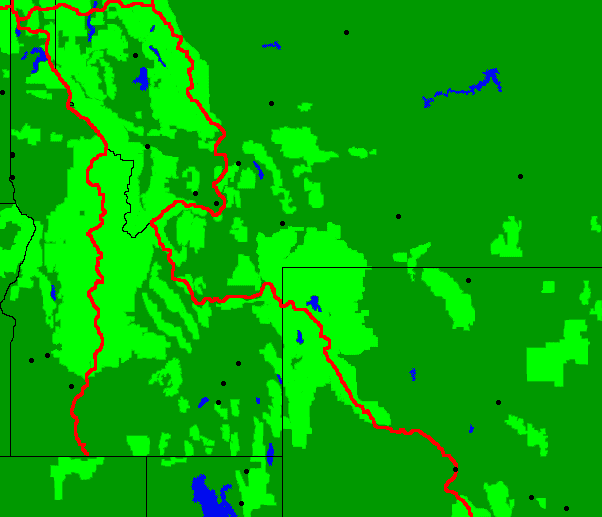
The Idaho Centennial Trail is 900 miles long and travels the north-south length of the state. Stephen Stuebner wrote the Idaho Centennial Trail Guidebook. The maps in the book are considered poor, but the Idaho parks website has printable topo maps for the trail.
| Location | Map | Mile |
| Southern Terminus | 1 | 0 |
| I84, US30 - Hammett, Idaho, PO | 10 | 138 |
| US20, near Cat Creek Summit, 30 miles west to Mountain Home | 13 | 200 |
| Idaho 21, USFS614 Elk Creek Road , 4 miles to Stanley, PO | 23 | 322 |
| US12, Wilderness Gateway Campground | 45 | 635 |
| I90, Shoshone Park, 3 miles west to Mullan, PO | 59 | 810 |
| USFS Highway 9 Prospct Creek Road, Thompson Pass | 60 | 821 |
| Idaho 200, Clark Fork, PO | 66 | 891 |
| US95, 2, McArthur Lake State Wildlife Management Area | 70 | 960 |
| Pacific Northwest Trail Junction, Priest Lake | 75 | 1036 |
| Northern Terminus | 76 | 1048 |
The 740-mile Northern Forest Canoe Trail (NFCT) connects waterways from the New York state’s Adirondack Park to the Canadian border in northern Maine. Following traditional travel routes used by Native American, settlers and guides, the NFCT connects 22 rivers and streams, 58 lakes and ponds and 45 communities. There are 13 maps at $10 each, or $78 for the 13 map set from The Mountaineers, who also publish the $25 guidebook.
New York
147 Miles
The NFCT runs through the heart of the scenic Adirondack Park. Starting at the NFCT’s western terminus in Old Forge, the trail goes through the Fulton Chain of Lakes on the way to Long Lake and the Raquette River in the High Peaks Wilderness. From there, it heads to the Saranac Chain of Lakes to the Saranac River, where it drops off the Adirondack Plateau into Lake Champlain. Use Maps 1-3 for this section.
Vermont/Québec
174 Miles
Vermont is home to the eastern edge of Lake Champlain, one of the most storied lakes in America and the largest water body on the trail. The Missisquoi River flows through farm country and enters Lake Champlain through a delta protected by a National Wildlife Refuge. The “Grand Portage” connects the Missisquoi valley with Lake Memphremagog in Quebec. The Clyde River flows through remote fens, but it also has stretches of whitewater. The Nulhegan River drops through a National Fish & Wildlife Refuge on its descent to the Connecticut River valley. Use Maps 4 – 5 – 6 for Vermont, Quebec, and part of New Hampshire.
New Hampshire
72 Miles
New Hampshire is home to three of NFCT’s rivers: Connecticut, Ammonoosuc, and Androscoggin. The
The Connecticut offers a nice ride on swiftwater as it meanders through a broad valley to the Upper Ammonoosuc River. In this section, the Northern Forest Canoe Trail is also part of the Connecticut River Paddlers’ Trail. The Upper Ammonoosuc is a fairly slow-flowing river with a few rapids. The Androscoggin is wide and swift with long sections of whitewater here. The river section is part of the Androscoggin River Trail. Use Maps 6 and 7 for New Hampshire.
Maine
347 Miles
Maine contains more miles of NFCT waters than any other state or province on the trail. The Rangeley Lakes are large and surrounded by conserved forests and mountains. The South Branch of the Dead River provides a whitewater run when it has enough water to be paddled. Flagstaff Lake spreads out beneath the dramatic ridgeline of the Bigelow Range. The Dead River is placid until it tumbles over Grand Falls. Spencer Lake and Stream are remote and scenic. The Moose River flows through many lakes and ponds as it meanders to Moosehead Lake, which is the largest in Maine and part of the Thoreau Wabanaki Trail. The West Branch of the Penobscot is wide and slow and ends in the open stretches of Chesuncook Lake. The Allagash Wilderness Waterway is a spectacular ribbon of lakes, ponds, rivers and streams winding through northern Maine. The St John River flows through a scenic, international valley to the eastern terminus of the Northern Forest Canoe Trail. Use maps 8-13 for Maine.
Skills:
I'll need to pole upstream, descend rapids up to class IV, cross large, exposed lakes subject to wind and waves, and portage.
In late summer, some sections of the Trail may be too dry to paddle. Paddlers also need to be aware of dam releases, information from water gauges found across the NFCT can be found on the American Whitewater Website. Generally, the water levels (and bugs) are more reliable in May and June, and the sun and warmth are more reliable in July and August. September and October often provide good paddling weather and better water levels than late summer.
Some Possible Supplementary Publications
Connecticut River Paddlers Trail (Map)
Developed by the NorthWoods Stewardship Center, the Vermont River Conservancy, and the Vermont Department of Forest Parks and Recreation.
Northern Forest Canoe Trail Through-Paddler's Companion $25
Katina Daanen
Paddling Through Time
Paddling the Northern Forest Canoe Trail: A Journey Through New England History
A Kayaker's Guide to Lake Champlain: Exploring the New York, Vermont & Quebec Shores
Catherine Frank & Margaret Holden
St. Regis Canoe Outfitters (Toll free @ 1-888-775-2925)
PO Box 797, Saranac Lake, NY 12983
Adirondack Paddler's Guide 3rd Edition
Adirondack Paddler's Map - North
Adirondack Paddler's Map - South
Adirondack Paddler's Map - Close-up Series: St Regis Canoe Wilderness
Adirondack Paddler's Map - Close-up Series: Saranac Lakes
Adirondack Paddler's Map - Whitney Wilderness
Adirondack Paddler's Map - Raquette River
Above the Gravel Bar: The Native Canoe Routes of Maine
The 2,421.4 mile Hot Springs Trail goes from Santa Barbara to Canada. 96 wild and resort hot spring are visited. Aria Zoner made up the route and wrote the 4 guidebooks.
Guidebooks:
The Hot Springs Trail Almanac: A Thru-soaker's Photographic Reference
The Idaho Soaktennial Trail: A Soaker's Rendition of the ICT
The High Sierra Hot Springs Trail: Thru-soaking the Sierra Nevada
The Hot Springs Trail: Official Guidebook
www.hotspringstrail.org

Many people walk from Land's End to John O'Groats in the ![]() United Kingdom, about 1000 miles. The prime attraction on this trail would be all of the historic structures, canals, etcetera. There are multiple trail routes, so I'll have to do a lot of research to pick the right one. I hiked Offa's Dyke in 2009, shown at left in blue, so I have an idea how walking in Great Britain works. Being wet all the time was a problem, so I'd have to plan a lot of hotel or B&B rooms.
United Kingdom, about 1000 miles. The prime attraction on this trail would be all of the historic structures, canals, etcetera. There are multiple trail routes, so I'll have to do a lot of research to pick the right one. I hiked Offa's Dyke in 2009, shown at left in blue, so I have an idea how walking in Great Britain works. Being wet all the time was a problem, so I'd have to plan a lot of hotel or B&B rooms.
Rather than walking from end to end, I might just hike a few of the long paths. Typically, each might be a hundred or two hundred miles long. Here are some of the fairly long paths in Great Britain.
Long Distance Paths:
Anglesey Island Coast Path
Cleveland
Coast to Coast
Cornwall Coast Path
Cotswold
Glyndwr's
Great Glen
Hadrian's Wall Path
North Downs Way
Offa's Dyke Path
Peddar's and Norfolk Coast
Pembrokeshire Coast Path
Penine Way
Ridgeway
South Downs Way
Southern Upland
South Scotland
Southwest Coast
Speyside
Thames Path
West Highland Way
Yorkshire Wold
In my Journal of My Walk on Offa's Dyke, I discussed various lessons learned and suggestions for future walking in Great Britain.
Someday I plan to drive around to many different National Parks, Forests, etcetera, with a backpack, and get out and hike as long as it takes to make a proper exploration of each place.
The Israeli National Trail seems interesting from the history and archeology point of view. The English language guide books are quite expensive since they are out of print. A reasonable alternative is to use topographic maps. There are about 20 plastic topo maps which cover all of Israel at 1:50,000. On the back is additional information and blown up maps of areas of interest. Not all of the 20 maps have the INT on them, so some are not required. The INT is shown as are all side trails which would be of interest. In the northern part of the country, a hiker passes through villages often enough that tap water supplies all needs. In the south, trail angels have buried enough caches that so long as the hiker carries a couple of gallons, there won't be problems. In national parks, camping is allowed only in designated areas.
Friday, Saturday, April 26, 27, 2013
Billygoat and the Israeli National Trail
Billygoat hiked the INT in 2011 with Tigger and Chuck N. He said a local contact (His was Edo) was necessary to understand how to use the post office for general delivery, to rent a cell phone, and to do other set up items that are a bit different than in America. So I should find a local contact. Billygoat mailed himself food but one could easily buy nuts, cheese, salad, olives, and water in every town. Food cost about twice the US price. They often stayed in a Kibbutz, ~$30 breakfast included. Taxis are everywhere and are the equivalent of hitching in the US, but the price should always be negotiated before the ride. They used taxis to access the Dead Sea and Mosada. Jerusalem and the Sea of Galilee are also off trail. If you rent a car also rent a gps (roads are ancient, winding, etcetera) from the same vendor, but it won't suggest routes through the West Bank, so watch maps too to keep routes reasonable. It is very useful to have a phone and they can be rented. For example, water cache locations were often texted to them, and the phone was used to set up lodging. But phone calls to the US were more economical using cards and the many public phones. I should learn the blaze convention because it encodes NOBO vs SOBO, turn information, etcetera. The trail is ~650 miles, passes right through Tel Aviv, is in good condition, and is little used. The Negev Desert has no plants or animals and they found it necessary to pay someone to place water caches. Generally, this cost about $20 for 4 1˝ liter bottles. But they found old water caches, were given water by campers, and one could get water by holding up a jug by a road. He hadn't seen buried general use caches (per Tamir) but said they didn't know and so didn't look. Starting about the 25th of March it gets hot in the Negev Desert so hiking is generally NOBO in the spring or SOBO in autumn. Wear long pants and follow other local customs in towns or near groups or people will be less willing to socially engage. But shorts in the desert were fine. Most people are fairly secular. Virtually everything is closed Saturdays. Israel is very crowded at Easter, so avoid that time. There is a current English guidebook that is in print, much improved, and costs $65. They didn't need supplementary maps. Everything about the trail will have a steep learning curve. ATMS are everywhere: larger, less frequent, withdrawals keep cumulative fees lower. Airfare was $1000. He spent $20-50/day. Many people are armed, and soldiers are everywhere, but this is normal and doesn't necessarily indicate a troubled time.
Tuesday, June 11, 2013
Pinco and the Israeli National Trail
Pinco and I discussed an ADZPCTKO style kickoff for the Israeli National Trail. If he starts it, I promised to market it to American long distance hikers. Most of it would be in Hebrew, the language of most of the hikers. But foreigners would also be accommodated. It would be about March 1, for northbound hikers. The INT is about 600 miles, so would take 5-6 weeks for an experienced long distance hiker to complete. But there are sites, such as Nazareth and Jerusalem, which are off trail, and which foreign visitors would want to see, so 2 months or more are recommended. Hitchhiking is common. Pinco confirmed the existence of the large water caches, but warned that they may get used up in the high season. Spring is much preferred over fall since spring rains bring green and flowers, whereas fall is a much drier, browner season.
Israeli National Trail Wants
Pimsleur CDs to learn to speak Hebrew
A book to learn written Hebrew or
An iPod app to translate written Hebrew
The Israel Trail Guidebook
An Israel tourist book
The Lycean Way book
In a bookstore I saw Hebrew in 10 Minutes a Day, by Kristine Kershul, a workbook with a CD from which I might be able to learn to read and write. A search online showed other books I didn't examine in person.
Perhaps as an adjunct to hiking the Israeli National Trail I could walk the Lycian Way along the coast of Turkey. It is 510 km long and travels from Ölüdeniz to Hisarcandir, or across ancient Lycia. It is blazed with red and white in the European Grande Randonnee fashion. Recommended seasons are February–May and September–November. The route is mostly footpaths and mule trails, with rocky tread, often ascending and descending as it traverses the coast. Kate Clow produced the guide books and maps, which also give background and historical information. Garmin gpx GPS files are available. A little internet searching on the Lycean Way will turn up several other routes in Turkey, some with guidebooks also by Kate Clow. Turkey's Lycian Way was recommended to me by long distance hiker Tessa of New Zealand as both a nice coastal walk and as a historical walk, with ruins from the Greeks, Romans, and other civilizations. One can camp along the way, and the trail takes perhaps 2-3 weeks.
One can hike across ![]() New Zealand, which would take several months. The Te Araroa Trail will eventually run the length of the country, but is not yet complete. Or, one can make up a route to walk. I've obtained some digital maps from Trauma, who hiked across the South Island a few years ago.
New Zealand, which would take several months. The Te Araroa Trail will eventually run the length of the country, but is not yet complete. Or, one can make up a route to walk. I've obtained some digital maps from Trauma, who hiked across the South Island a few years ago.
Alternatively, one could simply hike the most beautiful and ecologically diverse locations in ![]() New Zealand, partly by walking and using public transit to traverse the country, then perhaps later renting a car to pick up trails that were not easy to get to. Apex is a local car rental firm that is cheaper than the international competitors like Avis or Hertz. The Department of Conservation is roughly equivalent to our Forest Service. For a relatively small fee, one can buy an annual pass to their extensive network of huts or bunkhouses.
New Zealand, partly by walking and using public transit to traverse the country, then perhaps later renting a car to pick up trails that were not easy to get to. Apex is a local car rental firm that is cheaper than the international competitors like Avis or Hertz. The Department of Conservation is roughly equivalent to our Forest Service. For a relatively small fee, one can buy an annual pass to their extensive network of huts or bunkhouses.
Friday - Sunday, October 11 - 13, 2013
ALDHA Gathering at Shippensburg University
Freebird's
Te Araroa, New Zealand Presentation
Gear can be very expensive in New Zealand, so bring a full set. Black Flies (Biting Flies), locally called Sand Flies, are common. Most DEET sold in New Zealand is perhaps 20-30%, so bring some 100% DEET from the US. Food can be bought in towns along the way, typically every few days. US debit cards work in ATMs, but watch the fees. Topo maps and notes are available on line free. A book is available which is useful for planning or for someone following your hike, but is not detailed enough for hiking. Most through hikes are southbound. Denatured Alcohol is called Methylated Spirits, is sold in liter bottles, and is dyed purple.
 These are known as the Great Walks.
Milford Track
Abel Tasman Coastal Track
Routeburn Track
Kepler Track
Lake Waikaremoana Great Walk
Tongariro Northern Circuit
Whanganui Journey
Heaphy Track
Rakiura Track
These are also well known.
Queen Charlotte Track
Tongariro Alpine Circuit
Dusky Track
What Americans might call hiking Kiwis would call Tramping. A good guidebook to well known wilderness routes there is Lonely Planet's Tramping in New Zealand by Jim Dufresne.
Informative websites:
New Zealand Parks and Recreation
Federated Mountain Clubs of New Zealand
General New Zealand Hiking Information
I like to take parallel routes where they are available and where I have already taken the primary route. Therefore, I'm interested in taking the TYT, which parallels the PCT from Tahoe to Tuolumne, someday. The TYT runs from Meeks Bay on the west shore of Lake Tahoe to Tuolumne Meadows. Except near Lake Tahoe, it never gained official recognition. It differs from the PCT for about half its length. It goes much lower than the PCT and visits the northern of the Kennedy Meadows resorts. A guidebook is long out of print. I have the National Geographic topographic map Carson - Iceberg, Emigrant and Mokelumne Wilderness Areas 807, and the Tom Harrison Recreation Map Lake Tahoe and Tahoe Rim Trail, which cover it, as well as maps downloaded from the internet.
| Location | Food? | Mile |
|---|---|---|
| Meeks Bay, Lake Tahoe Terminus | No | 0 |
| Phipps Pass | No | 10 |
| Join the PCT near Velma Lakes | No | 12 |
| Echo Lake Resort | Yes | 31 |
| US50 Echo Summit PCT | Yes | 33 |
| South of Carson Pass near Frog Lakes split west from the PCT | No | 48 |
| Fourth of July Lake | No | 53 |
| Summit City Creek, partially unmaintained trail | No | |
| Lake Alpine (Grocer, Ski Areas) | Yes | 71 |
| Clark Fork Meadow (road?) | No | 88 |
| Kennedy Meadows Resort (store, restaurant) | Yes | 108 |
| Relief Reservoir | No | 110 |
| Bond Pass | No | 121 |
| Join PCT | No | 123 |
| Tuolumne Meadows | Yes | 168 |
Shenandoah Area
The area between Great North Mountain (USFS) and Shenandoah NP has many trails, some several days long. PATC and NGTI maps would describe all. The branches of the Shenandoah can be canoed. Virginia has many bike trails, and a state bike trail map.
Blue Ridge and Skyline Bike Ride
There was a fairly good guidebook for riding the BRP and Skyline Drive for sale in the BRP Viaitor Centers. The New River Trail Virginia State Park could be added as a spur, and perhaps many other bike routes. Research is required.
Southeast Wilderness Wander
The area south and east of Great Smoky Mountains NP has much contiguous National Forest and many trails. There are many famous wilderness areas, historic sites, water falls, etcetera. A trip beginning in GSMNP would allow reservations for camps far in advance. The BMT and many interesting sites could then be explored in the park. Shining Rock requires bear cans. Many wilderness maps have USFS detailed waterproof maps. Experience on this trip shows them to have unmaintained, difficult trail systems: thewse more detailed maps would be nice. All other scenic detours I took were also overgrown: loppers and a saw or hatchet might be handy. Planning a little extra time for such areas might allow me to leave trails better for others, or smaller tools might be used to force my way through quickly. Setting base camps and day hiking might allow more thorough exploration of local trail systems. Mapping of all interesting sites might suggest a good book, or much winter research. Appalachian Trail and BMT shelters and resupply town info would be handy.
USFS Maps to Research:
Ellicott Rock Wilderness
Scale - 2" to the Mile
Contour Lines - Yes
Paper
Congress established the 3,300-acre Ellicott Rock Wilderness in 1975 and made additions in 1984. This wilderness now contains 9,012 acres in the North Carolina, South Carolina, and Georgia. The wilderness is about 16 miles north of Walhalla, SC, 7 miles southeast of Highlands, NC, and 19 miles northeast of Clayton, GA. Straddling the 15,000-acre Chattooga Wild and Scenic River corridor, it provides a large, undeveloped area within easy driving distance of millions of Americans.
Birkhead Mountains Wilderness
Year - Revised August 2011
Scale - 1:24,000
Topo Lines - Yes
Contour Interval - 100 feet
Plastic
The Birkhead Mountains Wilderness is managed as part of the Uwharrie National Forest in North Carolina. It includes 4,790 acres at the northern end of the Uwharrie Mountains and is made up of sevearl long, wooded ridges and surrounding drainages. Elevations range from 450 feet along some stream bottoms to 950 feet on Cedar Rock Mountain. The moderately steep terrain is marked by rock outcrops and is dissected by several small, clar streams which feed the Uwharrie River. The forest cover is mostly old-growth hardwoods, with some pine and a variety of understory species.
Harmon Den & Hot Springs Area Trail Map
Year - 2002
Scale - 1:24,000
Topo Lines - Yes
Plastic
Harmon Den offers 54.5 miles of trails with 14.2 miles of trails designated for horseback riding and 40.3 miles for hiking. In addition, miles of gated, dirt forest roads, shown in orange on the map, are open to horses. Other gated roads, shown in gray on the map, are not designated for horses. Horse may also be ridden on open roads, but watch out for traffic.
Hot springs area features 44 miles of trails with 13.4 miles designated for mountain biking. The Laurel River Bike Trail is blazed with yellow rectangles, while other bike trails are only signed. All other Hot Springs area trails are for hiking only.
Joyce Kilmer Memorial Forest - Slickrock Wilderness
Year - 1996
Scale - 1:24,000
Topo Lines - Yes
Contour Interval - 40 feet
Paper
The Joyce Kilmer-Slickrock and Citico Creek Wilderness areas share a common boundary along the Unicoi Mountains. Citico Creek Wilderness lies entirely within the Cherokee National Forest in Tennessee. Joyce Kilmer-Slickrock is also part of the Cherokee National Forest, but lies chiefly within the Nantahala National Forest of North Carolina.
Linville Gorge Wilderness
Year - 2014
Scale - 1:24,000
Topo Lines - Yes
Contour Interval - 40 feet
Plastic
Covering almost 11,800 acres, Linville Gorge Wilderness sits to the east of Mount Mitchell. The wilderness offers rugged and scenic gorges in the East. In addition, its land is laced with trails that wind through the thickets of mountain laurel that descends to the depths of the gorge. The Gorge's rim give awesome views of the Linville River spilling over layered rock.
Panthertown Valley Trail System
Year - 2013
Scale - 1:24,000
TopoLines - Yes
Plastic
The Panthertown Valley trail system is part of the Nantahala National Forest, managed by the Nantahala National Forest Ranger District. Located near the town of Cashiers, Panthertown Valley draws people interested in hiking, horseback riding, biking, fishing, wildflower viewing, camping and other recreational activites. There are approximately 30 miles of trails that range in difficulty level and use, many being mixed-use trails. There are approximately 7.45 miles of hike only trails, 1.65 miles of hike and bike only trails and 16.15 miles of hike, bike and horse trails.
Shining Rock & Middle Prong Wilderness
Year - 2003
Scale - 1:24,000
Topo Lines - Yes
Plastic
Shining Rock Wilderness in the Pisgah National Forest is made up of a series of high-elevation ridges on the north slopes of Pisgah ridge. The terrain is extremely steep and rugged, with elevations ranging from 3,200 feet on the West Fork Piegeon Tiver to 6,030 feet on Cold Mountain. Shinning Rock Ledge, which forms the area's backbone, is over 5,000 feet high, with five peaks at 6,000 feet.
Middle Prong Wilderness lies west of Shining Rock and is also in the Pisgah National Forest. The wilderness is also made up of steep and rugged high-elevation ridges.
Our Price: $6.00
South Toe River, Mt. Mitchell & Big Ivy Trail Map
Scale - 1:24,000
Topo Lines - Yes
Plastic
South Toe River area and Big Ivy are part of the Appalachian Ranger District on the Pisgah National Forest in North Carolina. The South Toe River map includes the Black Mountains, the Blue Ridge, and the headwaters of the South Toe River. The Black Mountains, capped with a forest of red spruce and Fraser fir, are named for the resulting dark color.
Big Ivy is beautiful, remote, mountain land with more than 30 miles of trails. The Big Ivy map covers land purchased in 1914 for a new national forest. "Ivy" is the local name for the mountain laurel shrub.
Our Price: $6.00
Wilson Creek National Wild & Scenic River Trail Guide
Year - 2013
Scale -1:24,000
Topo Lines - Yes, Contour Interval 40 feet
Plastic
With fantastic vistas, ridges, more than 4,000 feet high, whitewater rapids and trails that travel to spectaclar waterfalls, Wilson Creek offers great adventures for hiking, scenic viewing, mountain biking, fishing, camping, horseback riding and backpacking.
Our Price: $6.00
Red River Gorge Geological Area
Year - 2012
Scale - 1:24,000
Topo Lines - Yes, Contour Interval 20 feet
Plastic
The Red River Gorge is a unique and scenic natural area within the Daniel Boone National Forest in Kentucky. Known for its abundant natural stone arches, unusal rock formations and spectacular sandstone cliffs, the Red River Gorge has been designated a geological area by the U.S. Forest Service.
Our Price: $11.00
The Bigfoot Trail is a long distance hiking trail through the Klamath Mountains of northwest California and, briefly, southwest Oregon. The trail begins in the Yolla Bolly-Middle Eel Wilderness and ends near Redwood National and State Parks at the Pacific Ocean near Crescent City, CA. The major focus along the trail is conifer diversity, passing 32 species along the 360 miles. Also, en route, one traverses six wilderness areas, one National Park, and one State Park.
Of the 360 miles, approximately 100 miles are along seldom used Forest Service roads while the remaining segments are backcountry trails, either in wilderness or on National Forest land. The Pacific Crest Trail briefly coincides with the Bigfoot Trail in the northern Marble Mountain Wilderness and north of Seiad Valley to the edge of the Red Buttes Wilderness. Due to the strenuous nature of the trail and the fact that some section have been un-maintained for many years it is not a trail that can be hiked quickly. Experience using map and compass as well as the ability to read the landscape are necessary for a successful thru-hike. The Bigfoot Trail was originally proposed by Michael Kauffmann in 2009 as a suggested route to navigate the Klamath Mountains from south to north as well as a long-trail to introduce nature lovers to the biodiversity of the Klamath Mountains region.
It makes sense to buy the guidebook and maps, and the associated book about the trees, as well as all USFS wilderness topo maps for the region (listed on my PCT maps page). Then I would study all these and determine what additional maps I would want.
It makes sense to hike the Lost Coast Trail during the same trip as it is close by. I have the Wilderness Press map.
The Hayduke Trail connects the various National Parks of Canyon Country in Southern Utah and Northern Arizona (Zion, Grand Canyon, Bryce Canyon, Grand Staircase/Escalante, Glen Canyon, Capitol Reef, Canyonlands, and Arches). Water, Snow, and Permits for the several jurisdictions the trail passes through are challenges.
There is an ongoing effort to remove invasive Russian Olive and Tamarisk trees in the Escalante River drainage, and also to reintroduce beavers. Some research might be of benefit.
Sharon of PCT'03 hiked the Hayduke in a very high snow year, to make the water situation easier. She resupplied by hitching. Hitches took a long time: She just budgeted enough time. She got a permit only at Grand Canyon.
Guidebook "The Hayduke Trail" by Mitchell and Coronella
Large Scale Maps
Many National Geographic Trail Illustrated (NGTI) maps overlap, especially at the northeast end of the Hayduke Trail (HT), but cover little of the Hayduke. I feel that if a large scale map shows only a few miles of the HT, I don't need or want it. Here I list BLM 30'x60' quadrangles and NGTI maps which cover at least a half dozen USGS 7½' quads along the HT, and which I therefore intend to buy.
The Arches NP official map gives a large scale view. Various NGTI and BLM maps don't seem to be enough of an improvement to buy and carry.
NGTI 210 Canyonlands National Park covers 10 HT quads, and seems worth buying.
BLM quad Hite Crossing includes 10 HT 7½' quads.
NGTI 710 Canyons of the Escalante covers 11 7½' quadrangles of the Hayduke Trail.
BLM Smoky Mountain covers 13 quads.
National Geographic Trail Illustrated 262 Grand Canyon East includes about 14 quads. I already own it.
BLM Freedonia is good for about 11 quads.
BLM Kanab covers 12 Hayduke quadrangles.
Though the Hayduke book says that hiking out the canyon of the Virgin River in Zion NP can only really be done on the entrance road, busy and narrow Highway 9, there are trails to the north connecting to the Kolob Canyons Visitor Center along I15. The East Rim Trail (11 miles), West Rim Trail (13.5m), Wildcat Canyon Trail (4.8m), Connector Trail (4.1m), Hop Valley Trail (6.5m), and La Verkin Creek Trail (6.4m) are shown on the official park map and on the NGTI map. I plan to buy NGTI 214 Zion National Park and use it to take this route, even though the official map is probably good enough.
I've downloaded all seemingly useful NPS maps. I've also downloaded all 2011-2014 USGS 7½' quadrangle maps listed in the Hayduke book. These newer versions don't always include old, closed, overgrown, rutted, or etcetera, roads and trails that were covered on older versions. Therefore, I still need to consider downloading older versions where the route description includes using old roads as routes or landmarks. The USGS digital store provides all these downloads free. Although BLM New Mexico and Colorado websites provide BLM 30'x60' quad downloads free, I was not able to find them for Utah and Arizona. After collecting all such map files, I plan to digitally crop and annotate them before printing them all out.
Sunday, May 21, 2017
Apple Pie had many suggestions for Li and other alternative routes for the Hayduke Trail, and suggested I refer to her journal for notes.
| The Hayduke Trail | |||||||||
| # | Days | Miles | Exertion | Navigation | Water | Desolation | Hazards | Permits | Resupply |
|---|---|---|---|---|---|---|---|---|---|
| Arches National Park Miles to Zion NP: 808 | |||||||||
| 1 | 5 | 39.7 | Easy | Easy Moderate | Wet | Local | Flash Floods Courthouse Wash, Kane Creek Canyon | Arches NP | Moab All Services |
| Hurrah Pass Miles to Zion NP: 768.3 | |||||||||
| 2 | 7 | 47.1 | Moderate | Moderate | Damp | Backcountry | Flashfloods all Drainages | Canyonlands NP | No |
| Big Spring Trailhead Miles to Zion NP: 721.2 | |||||||||
| 3 | 11 | 67.9 | Difficult | Moderate to Difficult | Dry 3 Day Carry | Desolate | Flash Floods Climbing Exposure | Canyonlands NP, Glen Canyon NRA | No |
| Hite Miles to Zion NP: 653.3 | |||||||||
| 4 | 7 | 35.8 | Moderate | Easy to Difficult | Damp | Backcountry | Quicksand, Dirty Devil River Current, Poison Ivy | Glen Canyon NRA | Cross Highway 95 at mile 35.8 |
| Poison Spring Canyon Miles to Zion NP: 617.5 | |||||||||
| 5 | 8 | 48.9 | Moderate to Difficult | Moderate | Damp | Backcountry | Snow Avalanche, Climbing Exposure | Capitol Reef NP | 36 miles south on dirt Notom to Bullfrog Road to Hwy24 or 40 miles west on Burr Trail to Boulder |
| Burr Trail, Capitol Reef NP Miles to Zion NP: 568.6 | |||||||||
| 6 | 11 | 72.5 | Difficult to Extreme | Moderate | Dry, then Wet | Desolate | Poison Ivy, rattlesnakes, Scorpions, Quicksand (all along the Escalante River), Flashfloods | Capitol Reef NP, Glen Canyon NRA, Grand Staircase - Escalante NM | Coyote Gulch Thead 36 miles north on Hole in the Rock Road to Hwy12, 5 miles NW to Escalante |
| Hole in the Wall Rock Road Miles to Zion NP: 496.1 | |||||||||
| 7 | 12 | 80.8 | Difficult | Moderate | Dry | Desolate | Dry | Grand Staircase Escalante NM | |
| Round Valley Draw Miles to Zion NP: 415.3 | |||||||||
| 8 | 7 | 49.0 | Moderate | Easy | Damp | Backcountry | Flashfloods in Round Valley Draw, Hackberry Canyon, Paria River, Sheep Creek, Willis Creek | Grand Staircase Escalante NM | |
| Willis Creek Miles to Zion NP: 366.3 | |||||||||
| 9 | 8 | 66.3 | Moderate | Easy | Damp | Backcountry | None | Grand Staircase Escalante NM, Bryce Canyon NP | Mile 51 cross US89 or Stateline TH, 11 miles NNE to US89, 40 miles west to Kanab |
| Arizona State Line Trailhead Miles to Zion NP: 300 | |||||||||
| 10 | 7 | 60.9 | Easy | Moderate | Dry | Local | None | None | |
| Nankoweap Trailhead Miles to Zion NP: 239.1 | |||||||||
| 11 | 9 | 47.1 | Moderate to Difficult | Moderate | Wet | Backcountry | Exposure, Crossings of the Colorado and Little Colorado Rivers, Rattlesnakes, Heat | Grand Canyon NP | Cross US89 at mile 24 |
| Horseshoe Mesa Miles to Zion NP: 192 | |||||||||
| 12 | 6 | 34.9 | Moderate to Difficult | Easy | Damp | Backcountry | Exposure, Heat, Rattlesnakes | Grand Canyon NP | North Rim - Store, Restaurants |
| North Rim, Grand Canyon NP Miles to Zion NP: 157.1 | |||||||||
| 13 | 12 | 87.2 | Extreme | Difficult | Wet | Desolate | Exposure, Crossings, Flashfloods | Grand Canyon NP | |
| Hack Canyon Miles to Zion NP: 69.9 | |||||||||
| 14 | 9 | 69.9 | Difficult | Moderate to Difficult | Dry, then Moist | Backcountry | Exposure, Flashfloods | Zion NP | Cross Highway 389 at mile 29 |
| Weeping Wall, Zion National Park | |||||||||
| # | Days | Miles | Exertion | Navigation | Water | Desolation | Hazards | Permits | Resupply |
![]() The Ozark Highlands Trail runs east-west through the Ozark National Forest in Arkansas. It's 165 miles long, and there is typically little enough snow that it can be hiked any time through the winter. Greyhound serves the towns of Ozark and Fort Smith. I hiked the east end of it in 2011, but it would be nice to hike the rest.
The Ozark Highlands Trail runs east-west through the Ozark National Forest in Arkansas. It's 165 miles long, and there is typically little enough snow that it can be hiked any time through the winter. Greyhound serves the towns of Ozark and Fort Smith. I hiked the east end of it in 2011, but it would be nice to hike the rest.
Guidebook "Ozark Highlands Trail Guide" by Tim Ernst
Ozark Highlands Trail Association
National Geographic Ozark Highlands Trail Article
Wikipedia's Ozark Highlands Trail
The Ozark Highlands Trail, the Ozark Trail, and the Ouachita Trail are best hiked in the Autumn, Winter and Spring.
![]() The Ozark Trail connects various sections of the Mark Twain National Forest in Missouri. It's 340 miles long.
The Ozark Trail connects various sections of the Mark Twain National Forest in Missouri. It's 340 miles long.
Guidebook "The Ozark Trail Guide" by Carroll and Welch
The Sendero de Chile is a trail that runs the length of Chile. I don't really know if it's complete, so incomplete it's impossible to hike, or what. The website is in Spanish.
The Bibbulmun Track is a 1000 kilometer walking path from Albany to Perth in Australia. Maps are available. September to November would be a good season, with spring wildflowers. The 135 km Cape to Cape Track is nearby.
The Larapinta Trail in the McDonnell Range near Alice Springs has been recommended to me by Swami, as has hiking in the remote parts of Tasmania, some reachable only by small plane.
There is a 7 or 900 kilometer trail in Slovenia with hostels that are ~7€ if you are a member of the national mountaineering club. It must loop around a lot because Slovenia is not 700 km across.
In India there are many pilgrimages, some where the participants haul huge temples behind them.
In Korea, there are 2 long distance walks. One, around Jeju or Olleh island, is about 200 kilometers. The island is one of the most beautiful places in Korea. The other goes from Ddang Ggeut or the end of the world to Im jim gak, or from the southwest to the northeast of South Korea, and is 500 kilometers long.
The Trans Canada Trail, or Great Trail, in development since 1992, is a vast network of mostly rail trails and canoe trails. The intended rail trail users are hikers, cyclists, equestrians, and cross country skiers. In 2016, 21,452 kilometers (13,330 miles) were complete, with 240 gaps totalling 6,200 km (3,900 mi). Guide books for each province are available for ~$25, and information about each of the many separately named and managed segments should also be sought. On the map, Green Segments are completed rail trail, Blue shows a canoe route, and Red signifies a missing trail link. It appears that there are very long sections that are complete.

Canada also has a Bruce Trail which connects with upstate New York's Finger Lakes Trail System near Niagara Falls and continues north into Canada.