Summary, Web & Electronics, 2017
This page details the current equipment and practices I use to generate this website, and explores new techniques and devices I may try in coming years. I intend that this discussion will help me my organize my own thoughts and introduce useful changes, and that the discussion will be informative for other hikers in documenting their hikes. Still others using electronics in remote places may benefit.
Why I Wrote This Page
Several discussions during my 2017 hiking season got me thinking that new equipment and techniques are available which might do the job both better and more easily. On the other hand, there are limits to the money, time, and other resources I wish to spend on the website. My avocation is hiking, after all, not website writing. After Trail Days Dutch Apple Pie looked with shock at the weight and volume of electronic equipment I carry. It is fair to say that it far exceeds what most long distance hikers would take. Jim asked what the cost of running my website was. He then patiently listened and commented for well over an hour while I detailed the various difficulties. At Vermillion Valley, a John Muir Trail hiker told me in incredible detail about satellite text and position transceivers, battery chargeing systems, and hiking planning. Many other discussions over the years have led me to rethink my practices.
Please note that my needs differ greatly from those of hikers who can return home frequently.
Battery Life is a major issue. GPS watches must be recharged about daily, and are therefore difficult for me to use. If I left a cell phone or GPS unit on all day, battery consumption would necessitate daily charging. Whereas a short distance hiker can charge batteries after a day or a few days of use, I must be conservative with the use of any battery driven device so it can last for as much as 2-3 weeks between charges. And some devices are just too power hungry to consider.
A solar charger might help, but not under trees or clouds, or at high latitudes. And solar chargers work better if you tilt them towards the sun during long breaks: I pretty much wander around all day, so my solar panel would not usually be ideally oriented towards the sun. So I don't carry a solar panel.
Data Storage is another consideration. One example is data that must be loaded before a trip. Maps and tracklines loaded to a smartphone or GPS device for me need to last for months, and so have much larger file sizes than day hikers or typical backpackers. That means a device with a large memory and long load times. Mobile devices may have storage limits that are way bigger than someone hiking a few days can fill, whereas I can fill them easily. Examples are '2000 photos' or '500 waypoints'. When these limits are exceeded, I need to find a computer and move the files off the device to make it work again. That might leave a device crippled for weeks, as computers are not easily accessable to me on long hikes.
Computer Access is required to adjust parameters in some devices or to hack devices that are no longer functioning for some known or unknown reason. Where a day hiker can frequently use a computer or find an expert, etcetera, I need more bombproof devices and the ability to hack from borrowed computers with various operating systems. And I have to be able to keep hiking without useing the devices when they fail.
In Autumn of 2002, I became disgusted with mismanagement at work, and decided that I would quit and hike the Pacific Crest Trail in 2003. My friend Gene soon wrote the first version of this website and posted it on a free host service one night in early 2003. The content included various photos and maps copied from other websites, and paragraphs derived from information on other internet sites.
The next day, he walked into my cubicle and announced his feat. He reasoned that since few engineers quit jobs and go hiking for half a year, all of our mutual aquaintences would want to keep up with my trip. Furthermore, any other friends and family could use the website to track me.
My feelings on writing the site were mixed. The benefits Gene anticipated seemed worthwhile.
On the downside, though, it seemed to me that no two activities could be more mutually exclusive than spending months in remote areas while architecting and slamming code for a website. At the time, I knew almost nothing about writing HTML or other website design issues. Plus, how would I find or carry equipment and software to write the site? I had also decided that most of the photos I had taken of past hikes were not interesting, and that therefore I planned to take only a few dozen photos of particularly memorable events during the entire hike - perhaps one photo a week. Additionally, I planned to buy spectacular postcards along the way, write them to various friends and family, and eventually collect my photos and postcards into some album, which would be my only souvenir of the trip. A website seemed superfluous since postcards and phone calls would keep my circle of friends informed.
Still, Gene and I agreed we would work together and get something on the site whenever possible. I soon wrote a page with photos of my 1998 PCT hikes. From the trail, I would call Gene from payphones and send him postcards, and he would write paragraphs. Occasionally, I would find in a library a computer with an internet connection. I would call Gene, tell him not to edit at the same time I was writing, and slam paragraphs as fast as possible, since the time allowed on the public computers was rarely enough to relax and do a good job. Later, Gene would fix all my typos. In 2003, there was a device and service called Pocketmail, about the size of a smartphone, which enabled the writing, sending, and receiving of emails over analog phone lines. I didn't know about it before the hike, and by the time I figured out how useful it might be, there was not enough time left in the hike to order and use one. Along the hike, I managed to buy a digital camera and a bunch of memory chips, and we figured out how to mail the chips around and post the pictures occasionally. I also bought an audio recorder, but we never really fully figured out how to get the audio files from the field onto the website.
2003 - 2017 Changes in Website Creation Methods
In the 14 intervening years, I have gone through multiple generations of electronic devices, software packages, and website hosts. I've taken classes, and learned a great deal from other hikers and my own focused research. A later major section, in detailing the costs of running my site, will cover my 2017 editing techniques and equipment fairly thoroughly.
Over the years, I have come to better understand who the major users of this website are, and therefore what the website should include.
The first major customer base is my friends and family, who don't primarily concern themselves about hiking technique, but want to know what I'm doing, and perhaps read a few good stories. So I need to occasionally say where I am and how well the hike is going, and find some entertaining things to write about.
The second group is other hikers. For them, I try to note anything unusual about the area, as well as places to resupply, permits required, etcetera. Any difficulties or exceptional beauty would be discussed. If some other hiker tells me something I or other walkers might want to know, I will put that in the report. Fairly commonly, they try to infer some conclusion which I didn't think to make. For example, if one were to examine my daily mileages, and see that for some unexplained reason I travelled a significantly shorter distance one day than typical for that trip, that implies that that segment is more difficult than the others. Perhaps a couple of times a year, someone I don't know will email with questions about some obscure place I've hiked. Typically, the questions might have to do with burns or overgrowth, and other factors that might make a hike require technical skills or be especially physically demanding.
The third major consumer is me. For a few years after my 2003 PCT hike, I remembered all the good stories. But with my miles hiking, biking, and boating over 30,000 I've started to forget entire months long hikes. So the right sentence can bring back the great feelings of some special day. And I certainly put plenty of thought into whether I would like to hike in the same area again, and what I might do differently. Good notes are the only way I'll remember. I more frequently scroll through the pictures than read my paragraphs thoroughly. So pretty or informative images are important to me.
I suspect that other hikers and I want the same kinds of writings and information, but writing for others requires more attention to avoiding assumptions of my preferences and skills. I suppose this forces me to write better.
There is a long distance hiking community which includes many types of people other than long distance hikers. I have had many conversations with people who would probably never backpack overnight, let alone do a months long walk. Still, they are fascinated enough to ask questions, sometimes for hours, about every aspect of hiking. I try to make the write about different subjects, especially on days when nothing noteworty happened, or when a tricky situation came up, to inform and entertain such readers. Any number of store keepers, rangers, trail maintainers, trail angels, etcetera, who have to know the hikers they deal with, are potential readers. In some cases, they may request reports on trail, water, or snow conditions, and I will make the notes in my website.
Proprietary Websites & Social Media Versus HTML Website
Most hikers with on line journals use proprietary services such as Trail Journals, Facebook, or other social media websites rather than coding their own websites. Those concerned with higher quality photographs may use photo sharing services which distribute uncompressed images. Some discussion of why I choose to maintain my own site may be of value.
The most important reason I write my own code is permanency. Over the early history of my site I used several proprietary features offered by my server hosts to enhance my website. For example, within my pages themselves I try to keep photo file sizes small so the site loads quickly. At one time, I used a proprietary feature to offer more and bigger photographs to users who had the available bandwidth and wanted to see more pictures. But a few years later, the company terminated that proprietary feature on very short notice. All of the extra photos were lost, and I had to recode the affected pages. I lost many hours of hard work in photo and page editing, and many interesting images from my site. The point is, web companies are fickle: the whole company or some proprietary feature may disappear tomorrow, along with your journal. It's been 14 years since my site began, an eternity in internet time. Since all of my code is stored on multiple backups at home, any company which goes belly up causes only a temporary interruption: When I have time, I load the same code to another server company and I'm back in business. A related problem is that if a company decides that your data is old and not viewed often, or stale, it may delete the information, or severely compress your images. The compressed images may be so pixelated that the pictures really show nothing. I have found that I enjoy looking at my journals and images years after the hike, and I plan to keep refering to my website for decades to come. I keep no other notes, journals, or souveniers for most of my hikes, so I would be very unhappy to lose journals. Writing my own website enables me to keep it forever.
I can also edit it forever. Sometimes someone emails an interesting comment years after a hike, and I can just add it right next to the appropriate entry. Or if I read the page a few years later and decide I did a poor job of telling an interesting tale, I can fix it.
My site contains all sorts of tables, formatting, images of many sizes, image maps, etcetera. Since I have my own site, I can include anything I'm smart enough to code, whereas proprietary sites have many limits.
Viewing my Website on Cell Phones Versus Full Size Monitors
A few years ago, cell phones and other mobile devices with small screens became the predominant way of viewing web pages. My standard format was developed to be viewed on full size desktop or laptop screens. My text and images display too small on mobile devices. Additionally, mapped images probably don't work on cell phones. Preliminary research indicates that the solution to this problem will not be simple, and may require that I make major code changes. Since my site now contains over 300 HTML pages and thousands of images, recoding might require hundreds of hours of work. This is a major task I dread, but realize I must do. My research continues...
Java Coding for Maps
Some years ago, I started to develop java code to display the latitude and longitude of the cursor as a user views the maps on my site. I also want the user to be able to click various points and develop perhaps a comma separated variable file of lat, lon, image mapped attibutes, and user comments which the user could export to use elsewhere. I need to finish this project sometime.
Dollar Costs
Registration of my domain name, bedore.org or www.bedore.org, costs $7.39 per year. My server space costs $60 per year.
Home Computer Dollar Costs
A laptop computer costs a few hundred bucks, and must be replaced every few years. I use that laptop to edit and store the site when I'm not out hiking. Adobe Photoshop Elements costs about $100. I used the same version on several sequential laptops, but had to buy a new version due to Windows updates the last time I replaced the computer. I would not be satisfied with the quality of images processed in a less capable application. I usually slam code in the Notepad text editor. I've been writing the site so long I know the code tags I use most by heart. But if I wanted a fancier editor, that might cost something. I also need a File Transfer Protocol (FTP) Client Side Shell, which is freeware, and an Image Mapper, which also is freeware. I've completed several mapping projects using a Geographic Information System, also freeware.
On Trail Electronics Dollar Costs
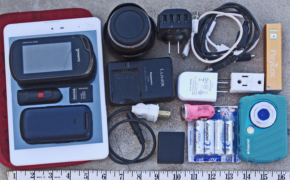
I write the website daily on a tablet, smart phone, or other mobile device. It must be replaced every few years at perhaps a couple of hundred dollars. (Failure modes are typically a steadily increasing collection of screen scratches and cracks, and more importantly the electrical connector becoming unreliable.) My μ4⁄3 camera, with interchangeable lenses and full manual control of focus, exposure, etcetera, cost $1,200 eight years ago and is still going strong. I don't carry the μ4⁄3 camera on rainy or dusty trips or anywhere I can't keep it safe and clean. A cheap digital camera I might use on rainy trips is less than $100 and might last a few years. A hiker GPS with topo maps might cost $500 and must be replaced after a few years as I wear the power switch out, exposing the guts to rain. Assorted battery chargeing cables, adapters, and power banks cost about $100. Assorted memory chips cost ~$100.
Equipment Bulk, Weight, and Protection
Besides monetary costs, I spend a great deal of time and effort creating this website. This section focuses on difficulties in carrying the equipment I use in the field.
Gear which is heavy has an obvious cost in physical exhaustion, and also must be packed carefully to avoid unbalanced loads. Gear which is bulky or fragile must be packed carefully and treated delicately to avoid breakage. I normally pack all gear which is small, fragile, or can be damaged by moisture in one or more clear plastic peanut jars. These jars are fairly long lasting, lightweight, and waterproof, and provide a little protection against crushing. The clear walls allow searches for small items without spilling the contents. In addition to electronics, I store other small items such as pocket knives, cigarette lighters, and compasses in the same jars. Tablets, Cameras, and other large gear which doesn't fit in the jars must be packed elsewhere and protected against mechanical or water damage. Wrapping a tablet between books or maps, and other gear in jackets or sleeping bags, can keep sticks or rocks banging the outside of the pack from damaging the device. Waterproof bags protect against sweat, rain, and soaking in failed stream fords.
| Electronics In My Pack | |
|---|---|
| Device | Grams |
| USB Charging and Data Cables One USB - Mini-B USB cable for Garmin GPS units. Several USB - μUSB cables for most other devices. I look for extra short (6-12") cables so they don't end up tangled together. |
5 / 66.5 |
| 4 Port USB Charger Input: 100-240 Volts, 50-60 Hertz, .5 Amp AC Output: DC 5 Volts, 2 Amperes split between 4 ports |
72.2 |
| 1 Port 2 Amp USB Charger Input: 100-240 Volts, 50-60 Hertz, .3 Amp AC Output: DC 5 Volts, 2.0 Amperes I may replace these 2 AC-USB chargers with one that can charge multiple ports at 2+ Amps each. |
44.2 |
| I may replace these 2 AC→USB chargers with one that can charge multiple ports at 2.4 Amps each, the present state of the art. 2 dual port charger kits at Costco have proprietary Apple cables or a potentially incompatible proprietary Qualcomm charge mode. An Anker 40 Watt 4 port charger has been reviewed and shown to produce almost the full 2.4 Amps from all 4 ports at once, which other brands did not match. It is on Walmart's website for $26. 4 High current 1' μUSB cables are on the same site for $13. | |
| Cigarette Lighter USB Charger Input: 12-24 Volts DC Output: DC 5 Volts, 1.0 Amperes I rarely have an opportunity to charge from cars, and don't always carry this. |
12.1 |
| USB Power Bank 2600mAh Capacity Input: DC 5V 500mA μUSB Output: DC 5V 800mA USB |
74.4 |
Battery sticks of much higher capacity are now commonly available. My present 2600mAh bank can half charge my tablet once. I found this one in a hiker box years ago, so it probably wasn't state of the art then. It has an on button that is clicked on by shifting gear in my pack, and will light an LED until I see it and turn it off that night. I bought a $30 power bank kit at Costco with 2 6,000mAh flat batteries the size and shape of a smart phone: (Battery: 2¾" x 5½" x 0.3� thick). It occurs to me that I could sandwich a smart phone (perhaps 5.96" x 2.91" x 0.30", 4070 mAh battery) between them for mechanical protection of the glass screen. Note that the 6,000 mAh is at the 3.7 Volt Lithium Ion Polymer Battery: At the 5V USB port less is available due to voltage conversion (4,440 mAh) and efficiency (?). Pushing charge into a phone at 2.4 Amperes, the power bank would deplete in less than 2 hours. 165.2g The kit includes 2 3' cables which support 2.4A Charge Current and High Speed Data Transfer 21.8g. Also included are 2 12 Watt single port wall warts. 49.7g |
|
| Panasonic μ4⁄3 Battery, Charger, AC Cord Charger Input: 100-240 Volts 50-60 Hertz .3 Amp AC Charge Output: 8.4VDC .65Amps This camera is discussed extensively elsewhere. Someone suggested I may be able to find a USB charger for these batteries, which might be less bulky, and might allow me to charge from a power bank or car battery, in addition to AC sources. Internet research did not yeild a USB sourced charger, and 12VDC or AC chargers were not much smaller than the device I have now. Some devices got very poor reviews for cheap construcion, overheating, or failing to work. Charging from AC sources takes many hours: a USB source might take longer. |
Batt 55.4 Chrg107.6 Cord34.9 |
| AC 120V 1-3 Adapter Electrical outlets may be few and in demand by other hikers at remote outposts... |
31.2 |
| AA and AAA Extra Cells As required for my GPS, Flashlights, Cameras, etcetera. |
4AA59.2 |
Tablet Computer and Neoprene Case I may replace this tablet soon, as it does not always charge, and its connector may be developing intermittent contacts. |
Tab444.8 Case86.6 |
Possible Smart Phone Replacement: LeEco Le Pro 3 |
|
| Thumb Drive, SD & μSD Cards, μSD - SD Converter Card On a Thumb Drive I carry all of my website, all web editing and loading software, all files for printed maps, more potentially useful files I didn't print, and all software and data required to hack my GPS or other devices, photos and files I generated during the trip, etcetera. My devices all use SD or μSD Memory Cards. With the converter I can pull all excess files off devices and onto the thumb drive whenever I have access to a full computer, possibly preventing slow device performance or crashes. |
10.4 |
| Cheap Digital Camera For dirty or rainy trips. Probably more rugged than a cell phone camera. |
136.7 |
| Garmin 650t GPS Includes Topo maps and locations of businesses and springs all over the USA. |
153.2 |
| Flip Cell Phone This phone is reliable, lightweight, rugged, and dirt cheap - $13. It stays off and well protected in my pack, so it is always ready and fully charged when I want to use it. I've resisted replacing it with a smart phone for these reasons. |
98.6 |
| Plastic Jar This peanut jar protects my devices from crushing and from water fairly effectively. Small items don't spill out and are easy to see through the clear walls. I also keep many other small items like pocket knives, compasses, etcetera in this container. |
118.2 |
| Total Weight: |
1,575 3½lb |
Time Spent Each Hiking Day
Throughout the day, I may be taking photos or GPS points for the site. Most evenings I think about whether anything worth writing about happened that day. If not, it may be interesting to write about an ongoing issue or comment on the area. Sometimes other hikers have told me something I or other hikers ought to know about. In any case, I figure out what I'll write before I turn the computer on. To conserve battery power, once I've turned the computer on, I type the day's journal fairly quickly and shut the tablet down right away. I can get one charge on my tablet or other devices to last for weeks so long as I'm careful to keep them powered on as little as possible. A power bank is a good backup, but I don't use it often.
Time Spent Each Town or Resupply Day
Resupply days are tough and busy for me. I rarely take a zero day or sleep in a town, because the town noise wakes me repeatedly through the night. My preference is to camp a couple of miles before town or hitching, and to leave town in time to hike a few miles into the woods before caming again. Hitching may take hours. In town, besides website work, I need to buy food and gear, get permits, phone and email people, get fire and weather reports, shower, launder, etcetera.
In the town, as a minimum, I need to upload the site. From my tablet, this could be done through WIFI or 4G cell phone data, if available. If a windows computer is available, I can FTP the site files. But sometimes town computers are Apple or Google devices, and the FTP Client executable I keep on my thumb drive won't run. Most town computers have a time limit of an hour or two, so if things don't work right away, I probably won't have time to figure out why.
Sometimes I need town computers to hack the software in my devices. Because I hike for months at a time, problems which are minor inconveniences for day hikers might keep me from using a device for weeks before I can find an available and properly functioning computer. For example, both cameras and GPS units have become swamped with excess files and stopped working. Until I found a computer to move the files off the device, I could not take more pictures or location. A GPS unit once ate all of its operating system, topo maps, and databases. The device was useless for a month before I had enough computer access to download gigabytes of repair software and maps and figure out how to fix it.
A town is the first place where I'll find enough computer access to research an issue I found on a hike and write about it on the site. If I can't get enough research time, I need to take enough notes that I'll remember the issue and can research and write in the fall.
Battery Charging
My μ4⁄3 camera batteries take several hours each to charge. With only one charger, I need to be at an electrical outlet perhaps 8 hours to charge two completely dead batteries. Most of my web equipment cannot be replaced in small towns, and working elsewhere while devices are dangling from an outlet might invite theft. Fortunately, it is rare that both camera batteries are dead, and my other devices can be charged in a few hours each. Usually, I can charge them all in parallel, so I don't need a 120V outlet for more than 4 hours. Sometimes it seems safe to leave items, or someone I trust can watch them. Sometimes I can charge the batteries next to where I'm doing other work, like next to a library computer, and do several things in parallel.
| USB Charge Rates | |||||
|---|---|---|---|---|---|
| Chargers→ ↓Sinks↓ |
Old 4 Port 2A/4 Scosche AC WW |
Trio AXS 2A AC WW |
Ubio 2.4A AC WW |
Old Bank .8A Paycor |
Ubio Bank 2.4A |
| Verizon Flip Phone | 5.04 Volts .2 Amps 1 Watt |
5.1 Volts .56 Amps 2.9 Watts |
4.91 Volts .15 Amps 4.7 Watts |
5.04 Volts .2 Amps 1 Watts |
5.04 Volts .57 Amps 2.9 Watts |
| Trio AXS Tablet | 5.05 Volts .41 Amps 2.1 Watts |
5.1 Volts .8 Amps 4.1 Watts |
4.94 Volts .39 Amps 1.9 Watts |
4.95 Volts .4 Amps 2 Watts |
5.02 Volts .77 Amps 3.9 Watts |
| Old Bank Paycor .5A | 5.05 Volts .3 Amps 1.5 Watts |
5.17 Volts .23 Amps 1.2 Watts |
4.87 Volts .28 Amps 1.4 Watts |
- | 5.03 Volts .27 Amps 1.4 Watts |
| 2017 Ubio Bank 2A ¾Charged | 5.03 Volts .56 Amps 2.8 Watts |
5.17 Volts .52 Amps 2.7 Watts |
4.84 Volts .45 Amps 2.2 Watts |
5.04 Volts .25 Amps 1.3 Watts |
5.01 Volts .55 Amps 2.8 Watts |
| Bike Flasher | Volts Amps Watts |
Volts Amps Watts |
Volts Amps Watts |
Volts Amps Watts |
Volts Amps Watts |
| Garmin 650t GPS* | Bright Backlight .15 Amps, Dim Backlight .1 Amps, Screen Off .03 Amps | ||||
| Volts Amps Watts |
Volts Amps Watts |
Volts Amps Watts |
Volts Amps Watts |
Volts Amps Watts |
|
| Volts Amps Watts |
Volts Amps Watts |
Volts Amps Watts |
Volts Amps Watts |
Volts Amps Watts |
|
|
Comments |
|||||
Testing Battery Charge Time and Rate
I tested several devices to see how long they charge at a fast rate, and how much time to a totally charged state.
Paycor / Old Power Bank Charging
I discharged the power bank until it self terminated and the charge indicator was extinguished. The load was my Garmin 650t running GPS, display, and backlight, ~0.15 Amperes. I used the Ubio 2.4 Amp charger, the lowest impedance / highest available current source. There was no observable negotiation period: the current went to and stayed at about .48 Amps immediately. The input rating is 0.5 Amps, close to the actual charge rate.
From a dead state, the Ubio Power Bank charges at the full ½ Amp rate for 4 hours, then with decreasing current until a full charge is reached after less than 5 hours. An indicator inside the power switch shines red when charging and blue when fully charged / charge current terminated.
| Paycor Bank Charging from Ubio 2.4A Wall Wart | ||||
|---|---|---|---|---|
| Hours: Minutes | Voltage Volts | Current Amperes | Power Watts | |
| 0:00 | 4.90 | 0.48 | 2.35 | |
| 0:28 | 4.92 | 0.48 | 2.36 | |
| 0:52 | 4.92 | 0.48 | 2.36 | |
| 1:19 | 4.90 | 0.47 | 2.30 | |
| 1:45 | 4.87 | 0.47 | 2.29 | |
| 2:27 | 4.90 | 0.47 | 2.30 | |
| 3:01 | 4.90 | 0.47 | 2.30 | |
| 3:27 | 4.90 | 0.46 | 2.25 | |
| 4:12 | 4.89 | 0.42 | 2.05 | |
| 4:24 | 4.90 | 0.38 | 1.86 | |
| 4:34 | 4.87 | 0.33 | 1.61 | |
| 4:44 | 4.97 | 0.00 | 0.00 | |

Paycor Bank Charging from Ubio 2.4A Wall Wart
Voltage (V), Current (A), Power (W) and % Charge versus Time (Hours:Minutes)
Ubio Power Bank Charging
I discharged the power bank until it self terminated and no charge LEDs were shown. The load was my Garmin 650t running GPS, display, and backlight, ~0.15 Amperes. For maximum compatibility, I used the Ubio charger and cable the bank came with. The Ubio 2.4 Amp charger was the lowest impedance / highest available current source. There was no observable negotiation period: the current went to and stayed at about one Amp immediately. Though the input ratings are 2 & 2.4 Amps, it actually charged at ~1 Ampere. An hour and a half in, the charger felt slightly warm, though the power bank didn't feel warmer than room temperature.
From a dead state, the Ubio Power Bank charges at the full 1 Amp rate for 4 hours, then with cycling and decreasing current until a full charge is reached after 6 hours. The fourth or last blinking LED is a good indication that the device is mostly charged, and that the remaining charge can only be obtained at a much slower rate. When all 4 LEDs illuminate steadily, the device is fully charged and has terminated charge current delivery.
| Ubio Power Bank from Ubio Charger | ||||
|---|---|---|---|---|
| Hours: Minutes | Voltage Volts | Current Amperes | Power Watts | Charge Indicator 4 LEDs |
| 0:00 | 4.85 | 1.05 | 5.09 | 1 blinking LED |
| 0:09 | 4.85 | 1.10 | 5.34 | 1 blinking LED |
| 0:30 | 4.88 | 1.11 | 5.42 | 1 blinking LED |
| 0:38 | 4.90 | 1.15 | 5.64 | 2nd LED blinking |
| 0:56 | 4.90 | 1.15 | 5.64 | 2nd LED blinking |
| 1:23 | 4.90 | 1.10 | 5.39 | 2nd LED blinking |
| 2:05 | 4.87 | 1.08 | 5.26 | 2nd LED blinking |
| 3:06 | 4.90 | 1.12 | 5.49 | 2nd LED blinking |
| 3:28 | 4.87 | 1.12 | 5.45 | 3rd LED blinking |
| 4:06 | 4.89 | 1.04 | 5.09 | 3rd LED blinking |
| 4:17 | 4.90 | 0.93 | 4.56 | 4th LED blinking |
| 4:28 | 4.88 | 0.62 | 3.03 | 4th LED blinking |
| 4:45 | 4.92 | 0.80 | 3.94 | 4th LED blinking |
| 4:53 | 4.90 | 0.77 | 3.77 | 4th LED blinking |
| 5:00 | 4.92 | 0.56 | 2.76 | 4th LED blinking |
| 5:12 | 4.91 | 0.45 | 2.21 | 4th LED blinking |
| 5:22 | 4.89 | 0.38 | 1.86 | 4th LED blinking |
| 5:27 | 4.90 | 0.30 | 1.47 | 4th LED blinking |
| 5:32 | 4.89 | 0.25 | 1.22 | 4th LED blinking |
| 5:40 | 4.89 | 0.20 | 0.98 | 4th LED blinking |
| 5:50 | 4.91 | 0.16 | 0.79 | 4th LED blinking |
| 6:01 | 4.93 | 0.12 | 0.59 | 4th LED blinking |
| 6:06 | 4.93 | 0.10 | 0.49 | 4th LED blinking |
| 6:14 | 4.99 | 0.00 | 0.00 | 4 LEDs On Steady |

Ubio 6000mAh Battery Charging from Ubio 2.4 Amp Wall Wart
Voltage (V), Current (A), Power (W) and % Charge versus Time (Hours:Minutes)
USB Ammeter Current Limiting?
The USB Ammeter / Voltmeter I'm using claims ratings of 3-8 Volts, 0-3 Amperes, and 1% tolerances. But I'm still wondering whether it limits the charge current by messing with the charge rate negotiation scheme between the charger and charged device. I suspected this because of the difference between actual and claimed charge rates for the Ubio Bank, and different charge rates for proprietary versus standard chargers feeding the Trio Tablet. Internet research on my devices and USB Ammeters was not helpful, but USB Standards hint at the answer.
Per USB standards, a USB Charge Port differs from a normal data port in having a maximum 200 ohm resistance between the D+ and D- data lines. A USB Data Port must at first supply low power, and then negotiate higher power through the data lines. There are various incompatible proprietary and standard negotiation schemes (including multiple both serial communication and non digital means). USB Charge Port is permitted to immediately supply .5-1.5A. So long as the Ammeter has inactive data lines (probably), it seems to me unlikely that it would interfere with negotiation.
Trio AXS Tablet Charge Rate Negotiation
Charged by the Ubio 2.4 Amp wall wart, at 7% charge, the charge rate went immediately to and stayed at ~4.94V and .65 Amps. But with the proprietary charger supplied with the tablet, the Voltage was 5.14-5.20, and the current was .41A for a few seconds, then .57 for a few seconds, finally settling at .82. During the charge, each time I powered up the screen to read the Charge %, the charge rate dropped down to .57A briefly before returning to .82 Amperes.
Trio AXS Tablet Charging
Because this tablet charges significantly faster with its matched proprietary charger than by a high current recent technology source, I first tested using the proprietary charger. The negotiation period is discussed above. I have carried and used the proprietary charger on most trips for the higher charge rate.
The portable computer on which I write the website is perhaps the biggest charging challenge. It can last for weeks if I am very conservative with power use - powering it up just long enough each day to write the journal. In such cases, I can see that with each use the charge decreases by perhaps 3-4%. On shorter trips I would also use it to look up birds, etcetera, using more power each day. These devices sometimes turn themselves on and waste substantial battery power, so even with conservative use, the tablet battery might be depleted unexpectedly.
With the proprietary wall wart, the high current charging was done in 3½ hours, and a full charge was obtained in a little more than 5 hours. The green indicator LED is a good indication that the tablet is 90% charged, and that the remaining charge will occur at a slower rate.
| Trio AXS Tablet Charged from Matched Proprietary Trio Charger | ||||
|---|---|---|---|---|
| Hours: Minutes | Voltage Volts | Current Amperes | Power Watts | % Indicated |
| 0:00 | 5.14 | 0.82 | 4.21 | 7 |
| 0:22 | 5.15 | 0.82 | 4.22 | 15 |
| 0:34 | 5.16 | 0.82 | 4.23 | 20 |
| 0:50 | 5.15 | 0.83 | 4.27 | 25 |
| 1:11 | 5.16 | 0.83 | 4.28 | 33 |
| 1:28 | 5.12 | 0.82 | 4.20 | 39 |
| 1:42 | 5.16 | 0.81 | 4.18 | 45 |
| 2:07 | 5.15 | 0.82 | 4.22 | 53 |
| 2:42 | 5.15 | 0.82 | 4.22 | 66 |
| 2:59 | 5.15 | 0.82 | 4.22 | 72 |
| 3:24 | 5.15 | 0.82 | 4.22 | 81 |
| 3:37 | 5.15 | 0.75 | 3.86 | 86 |
| 3:45 | 5.15 | 0.66 | 3.40 | 88 |
| 4:00 | 5.15 | 0.50 | 2.58 | 91 |
| 4:13 | 5.17 | 0.40 | 2.07 | 94 |
| 4:22 | 5.17 | 0.32 | 1.65 | 95 |
| 4:31 | 5.18 | 0.29 | 1.50 | 96 |
| 4:42 | 5.18 | 0.24 | 1.24 | 97 |
| 4:52 | 5.18 | 0.22 | 1.14 | 98 |
| 5:02 | 5.20 | 0.20 | 1.04 | 98 |
| 5:13 | 5.21 | 0.00 | 0.00 | 100 |

Trio AXS Tablet Charging from Trio Wall Wart
Voltage (V), Current (A), Power (W) and % Charge versus Time (Hours:Minutes)
Samsung Verizon Flip Phone Charging
I discharged the phone until it gave an audible charge warning and no charge bars were shown. I used the Ubio 2.4 Amp charger, as the lowest impedance / highest available current source. There was no observable negotiation period: the current went to and stayed at about 0.57A immediately. I never heard an audible full charge notification, though this phone sometimes does chirp for charge complete. Note that the charge current begins falling at 1 hour, while the display sort of implies a full charge with four bars in a half hour, but keeps scrolling the bars until the current really drops off at a couple of hours, when it stops scrolling / blinking.
I keep the flip phone turned off in my pack, with the battery installed, and power it up only to make calls. It stays fully charged for weeks, perhaps months. So I rarely need to charge from a dead battery state. But it's comforting to know that most of the charging is done in one hour, and all is done in two. The charge state indicator is useless for determining % charge during charging. But 100% charge is indicated by terminating scrolling, and the % bars would give at least a poor indication of charge state if one terminated charging for a while.
| Samsung Verizon Flip Phone from Ubio Charger | |||||||||||||||||||||||||||||||||||||||
|---|---|---|---|---|---|---|---|---|---|---|---|---|---|---|---|---|---|---|---|---|---|---|---|---|---|---|---|---|---|---|---|---|---|---|---|---|---|---|---|
| Hours: Minutes | Voltage Volts | Current Amperes | Power Watts | Charge Indicator 4 Bars in Cell Icon | |||||||||||||||||||||||||||||||||||
| 0:00 | 4.95 | 0.57 | 2.82 | 0 Charge Bars | |||||||||||||||||||||||||||||||||||
| 0:27 | 4.92 | 0.57 | 2.80 | All / 4 Bars Scrolling | |||||||||||||||||||||||||||||||||||
| 0:59 | 4.90 | 0.51 | 2.50 | All / 4 Bars Scrolling | |||||||||||||||||||||||||||||||||||
| 1:14 | 4.85 | 0.34 | 1.65 | All / 4 Bars Scrolling | |||||||||||||||||||||||||||||||||||
| 1:29 | 4.90 | 0.15 | 0.74 | All / 4 Bars Scrolling | |||||||||||||||||||||||||||||||||||
| 1:32 | 4.90 | 0.15 | 0.74 | All / 4 Bars Scrolling | |||||||||||||||||||||||||||||||||||
| 1:41 | 4.90 | 0.11 | 0.54 | All / 4 Bars Scrolling | |||||||||||||||||||||||||||||||||||
| 1:59 | 4.96 | 0.03 | 0.15 | All / 4 Bars Scrolling | |||||||||||||||||||||||||||||||||||
| 2:06 | 4.92 | 0.05 | 0.25 | All / 4 Bars, Not Scrolling | |||||||||||||||||||||||||||||||||||

Samsung Verizon Flip Phone Charging from Ubio 2.4 Amp Wall Wart
Voltage (V), Current (A), and Power (W) versus Time (Hours:Minutes)
How Long Should I Charge my Devices?
If I'm at an electrical outlet but I need to leave as soon as possible, I could leave after 4 hours knowing that all the devices were mostly charged, and that topping them off would would occur at a much slower rate. 100% charge would be reached on all devices in a little over 6 hours.
Percent Charge Indicators
The indicators on the tablet and Ubio Power Bank can be reliably used to determine the end of the high rate charging period and the fully charged / charge current termination time. Other devices reliably indicate only when they have a full charge and have terminated charge current.
Partially Charged Devices
If the devices were partially charged, they would charge at the high rate for a shorter time to the mostly charged state, and the topping off / lower rate time would probably be about the same.
100% Charged Devices
Beyond the fully charged time, the current goes to zero. Maintenance or trickle charging is handled by cycling the charge system on occasionally. Leaving the devices plugged in after 100% charge is indicated does not further charge the batteries. So if I'm in a hurry, I can stow the devices or leave after the 100% indication without missing any phantom charge opportunity. But if I'm not in a hurry, I may as well leave them plugged in so that any quiescent power use will be replenished.
Qualcomm�s Quick Charge 3.0
Quick Charge 1.0: 5 V, 2 A, 10 W, 2013
Quick Charge 2.0: 5 V, 9 V, 12 V, 2 A, 2 A, 1.67 A, 18 W, 2015
- Class A / B: 5, 9 and 12 Volts
- Class B: 5, 9, 12, 20 Volts
Quick Charge 3.0: 3.6 V to 20 V, 200 mV increments, 2.5 A or 4.6 A, 18 W, 2016
Quick Charge is connector and cable independent. 3.0 has INOV (Intelligent Negotiation for Optimum Voltage) which communicates with the device to request any voltage between 3.2V and 20V in 200mV increments. Gene's USB Volt Ammeter, rated 3-8V, does not work at the higher Voltages.
A New Lithium Ion Battery Charging System?
Friday, September 15, 2017
A JMT hiker and former Coast Guard helicopter paramedic had done much research and testing on his gear and had some interesting comments. He had a system using standard Lithium Ion cells, the diameter of a penny and a few inches long, to charge electronic devices. He had several cells, a flashlight, and chargers for AC-cell, solar-cell, and cell-USB. He claimed that since the cell could accept the full current availble from the solar panel, whereas a phone or similar device might limit the charge current, he could recover more solar energy with the cells. But efficiencies of voltage conversion and charging circuits, and of the cells, ought to be considered. He said 3800 mAH cells were state of the art, and recent 5000 mAH claims were dubious.
18650 LiIon Cells
Many types of chargers and devices like headlamps or flashlights are available. Charge Capacity has been developing at ~8%/year.
| Diameter | 18.6mm .73" |
| Length | 65.2 mm 2.57" Perhaps 68 mm with an internal protection circuit board |
| Discharge | 3.7 Volts |
| Charge | 4.2 Volts |
Typically, when I'm on trail, each evening I think about what I'll write on this website for the day. Then, I'll quickly power up a small computer, type the journal, and power the tablet down again. Since weeks may pass between towns and their 120V electrical outlets, only efficiency like this keeps my tablet or smart phone charged long enough.
I may be cold, wet, or tired, and I'm probably in my sleeping bag and hammock when writing. It's not a comfortable sitution for typing, so typos and fumbling are common.
I currently write the site on a text editor which color codes HTML tags, and sometimes offers to insert appropriate tags.
It occurred to me that if I wrote an application which simplified writing HTML, and automated adding Linnaean Binomial Species Names, I could focus on writing sentences and eliminate fumbling with HTML tags, brackets, and etcetera. I would use less time and battery power each day. This section discusses the proposed architecture, etcetera.
|
Why I supply Latin or Linnaean Binomial Species Names Long ago, I used to provide links to websites which gave interesting information about things that I had seen or discussed in the journals. After a few years, those sites might change or disappear, causing many broken links. When I had just a few pages, I could try every link on my site every couple of years, and edit out the broken links. Since I now have over 300 HTML pages, surfing and editing them all is no longer practical. Instead, I try to use terminology which the interested reader could put in a search engine and get results very close to the suject of interest. So for places and things, I am very careful with my terminology. For living things, I try to give the scientific binomial name. I have found that the common or English names of animals will give search results of sports teams, clubs, and everything but interesting information about the animal itself. A search on the binomial name yields all sorts of web pages of interest to wildlife enthusiasts... |
There are several free software development kits for Android devices. Generally, they run on Windows and other platforms, and allow one to code cell phone applications in Java or C++.
Automating the Page Template
The Header of each page on my site is fairly standard. I enter the same search terms as both Description and Keywords. With a text entry box, possibly able to supply obvious choices, like trail names (Pacific Crest Trail), states (Maine) or the year (2018), the code could generate these two lines. A title for the tab in a web browser is also part of the header. A tab title should identify the page fairly well in the first few characters, as that's all the user sees when many tabs are open. A text entry box would allow me to code that line. With these two controls, the application could write the entire header and the opening / closing statements of the body and page. At the top and bottom of each page body I have an H4 link back to my index page, possibly to the specific trail corridor. With a selection list of corridors, these index links could be written and inserted. An H1 centered headline is usually the second line in the body. It is usually a less terse version tab title specified in the header, so a text box that suggests that title would allow coding of this line. A call to a file naming and saving device would complete the auto coding of a web page template.
Since I've just determined the file name, I could autocode the line that needs to be added to my index page and save it someplace.
Automating Daily Reports
Every day I write a paragraph that has the date in a title, followed by some text, followed by a few lines of standard data, like the miles walked, camp location, etcetera. A text box that suggests the date, another for the body text, and more for the footer lines would allow coding of a standard paragraph. Sometimes I write additional paragraphs without header and footer lines: that option should be included. Spell checkers could be active in the paragraph boxes.
Keeping Paragraphs in Sequence
Somehow I would to put the paragraphs and tables in the right sequence / location. I could keep track of yesterday's line number, or use link location tags, or scroll through the file and pick the location, or store all the paragraphs in some sort of database that only assembes the entire page when requested.
Additional HTML Tag Generation
Several drop lists could simplify coding. Examples include &; Character Codes, HTML Tag Pairs, and Common/Latin names of species.
Table Coding
In the past, I didn't usually make tables in the field, but waited until the autumn editing season, becase it was too easy to screw up the many HTML tags required. A simple table tool might be handy. Any table tool ought to allow a background color of bgcolor="ffce9d", a darker version of my standard page color of bgcolor="#FFDFBF" (decimal 255, 223, 191), to highlight the table, a row or a cell.
GPS Location Tables
Sometimes I document trail intersections, water sources, and other locations of interest to hikers by GPS. A code could crawl through GPX XML text files and extract the Title, Comment, Time, Date, Latitude, and Longitude fields, and generate HTML tables. This is presently a tedious, eye straining, error prone autumn activity, but a code would make it possible to add coordinates to the website from the field. Provided that the daily waypoint files were processed in sequence, they would already be in order. But the timestamp could be used to sort if required, and by correcting from UTC to local time, perhaps lines could be color highlighted by date to allow easier correlation to the daily paragraphs. It's probably too fancy to bother with, but hyperlinks could allow jumping between the table and the daily paragraphs. As an alternative, the code could take locations from the device GPS and create tables of the points to be placed at the end of the file or each day.
Methods for Requesting Locations from GPS Aspect of the Android Location Manager
I need to either register as a listener to the GPS Provider (ex: GpsStatusListener) (or the Network Provider for cell tower and wifi triangulation) and specify a time or delta distance to continuously recieve updated location estimates, or call the locaction manager once: LocationManager.getGpsStatus()
| int | FORMAT_DEGREES | Constant specifing latitude or longitude units [+-]DDD.DDDDD |
| float | bearingTo(Location dest) | Bearing in degrees East of true North |
| float | distanceTo(Location dest) | Approximate distance in meters between this location and the given location. |
| float | getAccuracy() | Estimated horizontal accuracy of location, radial, in meters, 68% or 1 standard deviation. |
| double | getAltitude() | Altitude if available, in meters above the WGS 84 reference ellipsoid. |
| double | getLatitude() | Latitude, in degrees. |
| double | getLongitude() | Longitude, in degrees. |
Image HTML Coding
I rarely add images until the fall season because I don't have a big enough screen and a powerful enough image editor in field. But sometimes only an image tells a story. And coding to display images in the autumn is a tedious and eye straining exercise. If I could select one image file or a directory full of files, and extract the directory, title, suffix, width, and height, the application could write most of the image tag. One text box would allow me populate the alt and title tags, as well as a title below the image. The image tag could be coded in a centered paragraph, my standard format. Sometimes I use image mapping or place related photos in a table, but not commonly enough to automate those processes.
Weather Reports
I like to download the 7-10 day weather prediction each time I have internet access. Commercial weather websites are so bogged down with advertising that it's often impossible to download a report on slow, small town connections, so I use the National Weather Service. Often I'll use the location I will pass through in a couple of days, to make the report more accurate over the 7-10 days of walking. I like to add the text to the website, both so I can refer to it during the trip, and so I can remember years later. Again, it is a tedious and error prone process to edit out garbage and add tags to format the weather forecast. Maybe it's possible to pull the NWS forecast in a processing friendly format. If not, selecting and copying the 7-10 day text, then processing from the copy / paste buffer would be a huge improvement over editing entirely by hand. Changing Today and Tonight to the name of the day would be my preference, as would adding the date. A text box might allow me to type the location, while suggesting a suffix of 'NWS Weather Forecast' for the title. A table format would look nicer than the line break paragraphs I use now. Maybe a column each for the day name and day of month, each right justified and bold, then day or night, then the sentence, would be space efficient and readable. A header includes Location Name, Latitude, Longitude, Elevation, Humidity, Wind Speed, Barometer, Dewpoint, Visibility, Heat Index, and time of Last Update, which all seem valuable enough to include.
Wildfire Reports
It might be possible to similarly process inciweb wildfire reports for inclusion in my pages. There is a lot of formatting and excess stuff which varies from page to page, so automating might be tough, and the same idea of copying only the data of interest, and processing only that, might work. Not all fire data is of interest to me or other hikers, so the ability to skip some stuff is desireable.
Wednesday, November 15, 2017 Update
I replaced my worn out Garmin 650t with a Garmin eTrex 20x. At $155 with shipping and tax, it was almost as cheap, and a lot less trouble than $100 to ship the 650t in for repair. It operates by button rather than touch, so is compatible with rain, sweat, and boating. I'll also buy a cell phone with GPS and GLONASS as my on trail computer: It could be used as a gps in dry circumstances. After lots of thought about the Garmin inReach satellite text messaging, I decided against it. Instead, when phone reception is poor, I'll try and text people: text messages often get through when voice calls fail.
Earlier Analysis
Since my Garmin 650t failed recently, I need to consider what I should replace it with. The Garmin 650t is a handheld device with a touchscreen. It comes loaded with a topo map of the entire USA, and with a database of business, springs, etcetera.
I typically don't navigate with GPS, as I prefer to use a paper topo map, my watch, and landmarks. To determine direction, I usually watch the position of the sun or the North Star, Polaris, and take out my compass only rarely, perhaps on overcast days with no good landmarks in sight. I find navigating myself to be a fun and interesting activity, plus I learn much more about the area from maps than I would from a GPS. I think it is safer to navigate from maps, because I see all of the terrain and escape routes every time I refer to the map, and always know where I am relative to them. Paper maps don't run out of power or break when dropped.
However, GPS excels at some tasks. When hiking directions are to walk left up an obscure dirt road, for example, there are often many obscure dirt roads to choose from. Without GPS, I might try several before finding the right one. With GPS, I pick the best looking candidate, walk a few minutes, and see if the GPS shows me on the right track. I almost always pick the right one. The GPS can find businesses, springs, etcetera. Finally, I can document my route for my own future reference, or to help other hikers.
My three primary complaints about the Garmin 650t are the repeated failures related below, the device occasionally changing all sorts of setup parameters so that it takes 15 minutes of menu surfing to recover a useable state, and that the touch screen doesn't work correctly with rain, sweaty fingers, or other moisture. Drops of moisture are treated like finger commands, so that the devices will execute a bunch of unwanted instructions, either bogging down the operating system so you can't enter an actual command, or doing something you don't want and will have to reverse.
Failures of my Hiker GPS UnitsI started using a Garmin 450t in early 2010. The 450t wore thru the rubber power button in 2012, making it not waterproof, in less than 3 years. By the end of 2012, I was using a 650t. In June of 2016 the 650t had a total software meltdown starting in Vermont, on the AT. The operating system slowly ate itself, the topo maps, the database of locations, and possibly more. Garmin customer support was useless, refusing to give a straight answer to anything, over a long email conversation from several towns. If I shipped the device to them, they would fix it for $100, but they had no idea how long it would take, or how to return it to me on the trail. The device was useless until the end of the trip. Between that trip and my GDMBR ride, I hacked the device from my home laptop, using a bunch of hacking tools from Garmin to restore the operating system, topo maps from GPS File Depot, and locations of a few business chains from various internet sites. The very comprehensive lost Garmin location database was sorely missed. The operating system had to be hacked again later that year with the same Garmin tools, but held after that. On New York's Finger Lakes Trail System in 2017, I wore through the rubber power button again, making the device first not waterproof, then later totally unusable. The button life was about 5 years. |
It's a fair bet that if I buy a Garmin, it will have many of the same good and bad attributes, so a comparison of options follows.
| Comparison of Garmin Hiker GPS Units | |||||
|---|---|---|---|---|---|
| Model | Oregon 650t | Oregon 750t | Monterra TOPO | eTrex 20x | inReach Exp Plus |
| Size | 2.4 x 4.5 x 1.3 | 2.4 x 4.5 x 1.3 | Big? | 2.1 x 4.0 x 1.3 | 2.7 x 6.2 x 1.5 |
| Display | 1.5 x 2.5 | 1.5 x 2.5 | 4" - 2.82? | 1.4 x 1.7 | 1.4 x 1.9 |
| Pixels | 240 x 400 | 240 x 400 | 272 x 480 | 240 x 320 | 200 x 265 |
| Ounces | 7.4 | 7.4 | ? | 5 | 7.5 |
| Warranty | 1 year | 1 year | ? | 1 year | 1 year |
| Satellite | GPS, GLONASS | GPS, GLONASS | GPS/GLONASS | GPS | GPS |
| Control | Touchscreen | Touchscreen | Touchscreen | Buttons | Buttons |
| Data Bus | Unit-to-Unit, Connect� | Wi-Fi, Bluetooth�, ANT+�, Unit to Unit, Connect� | Wi-Fi, Connect, Bluetooth, ANT+� and NFC | Unit-to-Unit, Connect�, USB | Bluetooth, USB |
| Data Card | Micro SD | Micro SD | Micro SD | Micro SD | ? |
| Compass | Electronic | 3D Electronic | 3D Tilt-Comp | ? | Electronic |
| Altimeter | Barometric | Barometric | Barometric | ? | Barometric |
| Tides | Yes | Yes | Yes | Yes | ? |
| Battery | 2AA, NiMH 16H, Lithium? | 2AA, NiMH, 16H | 16H LiIon 22H 3AA | 25H | 100H LiIon |
| Memory | 4 Giga Byte | 4 Giga Byte | 3 Giga Byte | 3.7 Giga Byte | 2 Giga Byte |
| Waypoint | 4000 | 10000 | 4000 | 2000 | 500 |
| Routing | Automatic | Automatic | Automatic | Automatic | ? |
| Camera | 8 Megapixel | 8 Megapixel | 8 Mp, HD Video | ? | ? |
| Other | Active Weather | Android� | - | 2 Way Text | |
| $ GPS | 289 | 550 | 700 | 170 | 450 |
| $ / Year | 0 | 0 | 0 | 0 | $150 minimum |
|
Comparison of Garmin Handheld Hiker GPS Units
Oregon 650t
Oregon 750t
Monterra TOPO
eTrex 20x
inReach Explorer Plus | |||||
Satellite Text Messaging - Do I want It?
In short, I personally don't want the extra weight, cost, and hassle of inReach or any other similar device. I consider myself to be much safer while hiking than when in town. I don't do anything which I think is dangerous, and with 30,000+ miles of wilderness travel, I have more experience than most. My hikes would make the worlds most boring TV program.
However, people at home seem to worry more about hikers who are safe watching birds and smelling flowers than about themselves. People in society are always in danger from drivers who are drunk or messing with cell phones. Criminals abound in town, but are too lazy to hike out into the hills. The dangers of living in cities are much, much higher than those of hiking. Still, people irrationally worry excessively about hikers.
I currently spend a great deal of time and effort emailing, writing the website, calling, and writing postcards to stay in touch. WIFI, cell towers, and postal facilities are not available in many towns. Everyone who communicates with me regularly knows that, and has probably discussed it with me in great detail. They all know that even though I may be able to communicate frequently in some areas, in others I won't be able to find communication facilities that work correctly for as much as a month.
And still, in various incidents, people have gotten very upset that I haven't called, emailed, posted, etcetera. Or they have called the forest service, or emailed a bunch of people, etcetera. And then I get frustrated, because they have created a giant, totally unnecesary, pain in the butt.
Avoiding nuisances like that is one of 2 reasons I'm considering inReach. The other is so that I can be quickly called home if my mother needs me to be a caretaker. A third, less critical benefit is that my location each day would be viewable on a map on a website.
| Garmin inReach Specifications | |
|---|---|
| Dimensions | 2.7" x 6.5" x 1.5" (6.8 x 16.4 x 3.8 cm) with keypad and SOS door bump |
| Weight | 7.5 oz (213.0 g) |
| Water rating | IPX7 |
| Battery | Rechargeable internal lithium ion |
| Display type | transflective color TFT |
| Display size | 1.4"W x 1.9"H (3.5 x 4.7 cm); 2.31" diag (5.9 cm) |
| Display resolution | 200 x 265 pixels |
| Battery life | Up to 100 hours at 10-minute tracking mode (default); up to 75 hours at 10-minute tracking with 1-second logging; up to 30 days at the 30-minute interval power save mode; and up to 3 years when powered off |
| Memory/History | 2 GB |
| High-sensitivity receiver | Yes |
| Interface | USB |
| Ability to add maps | Yes |
| Waypoints/favorites/locations | 500 |
| Routes | 20 |
| Preloaded maps | The North America SKU of the inReach Explorer+ comes preloaded with a 1:24k map of Garmin Yarmouth (Former DeLorme) North America data of the U.S. and Canada. Mexico also is included at a 1:125k scale (derived from Garmin Yarmouth Digital Atlas of the Earth). |
| Barometric altimeter | |
| Compass | Tilt-Compensated 3-axis |
| Camera | No |
| Wireless Compatible Bluetooth | |
| Trigger an interactive SOS with 24/7 search and rescue monitoring center | |
| Send and receive text messages to SMS and email | |
| Send and receive messages with other inReach users, exchange locations | |
| Track and share location with friends and family on web-based MapShare portal | |
| Request weather forecasts for current location and planned destination | |
| Virtual keyboard for custom text messaging | |
| Send waypoints to MapShare portal during trip | |
| Send route selection to MapShare portal for friends and family to see progress | |
Handheld Satellite Communicators with GPS Navigation You may venture off the grid, but you�re never out of reach � as long as you�re carrying an inReach SE+ or inReach Explorer+. These handheld satellite communicators are designed for the outdoor enthusiast who wants to roam farther and experience more � without compromising their loved ones 'peace of mind'. From backcountry experiences to international adventures, inReach provides communication, location sharing, navigation and critical SOS functions for anyone who loves getting away from it all, on land, water or in the skies.
Explore Anywhere. Communicate Everywhere. In case of an at-risk situation, you can also use inReach to trigger an SOS to the 24/7 monitoring center, text back and forth about the nature of your emergency, and receive confirmation when help is on the way.
No Cell Tower? No Phone Service? No Problem.
Track and Share Your Whereabouts
Pair with Your Mobile Device
Get Weather Wherever
Who Will Answer Your SOS? GEOS Will.
Which inReach Is Right for You?
Affordable, Flexible Satellite Airtime Plans
Unlimited Cloud Storage and Trip Planning are Included
Built for the Rugged Backcountry
1 See Garmin.com/inreach faq for compatibility | |
Iridium Satellite Constellation
inReach messages are sent on the Iridium satellite network. The constellation consists of 66 active satellites plus spares in orbit. Satellites are in Low Earth Orbit (485 miles) in six 30° spaced near polar planes (inclination of 86.4�). The satellites have an orbital period of roughly 100 minutes. Iridium / inReach claims 100% global coverage, but deep canyons or cliffs would cause reduced sky visibility.
Some hikers who had tested their equipment very thoroughly told me that on the AT south of the Smokies in a side by side test, a SPOT was not able to push a location to satellite for over 6 hours, while the Garmin In Reach pushed a location through every two minutes for 24 hours consistently. This area has deep canyons, lush forests, and heavy clouds and rain: very tough test conditions.
GPS has 6 MEO planes at 55� inclination with an orbital height of 12,540 miles and an orbital period of ½ a sidereal day - 11 hours and 58 minutes.
| Plan Name→ Message Type↓ | Safety | Recreation | Expedition | Extreme |
|---|---|---|---|---|
| SOS | Unlimited | Unlimited | Unlimited | Unlimited |
| Text1 | 10/mo | 40/mo | Unlimited | Unlimited |
| Preset2 | Unlimited | Unlimited | Unlimited | Unlimited |
| Tracking Interval | 10 minutes + | 10 minutes + | 10 minutes + | 2 minutes + |
| Tracking Points | 10¢ ea. | Unlimited | Unlimited | Unlimited |
| Location Pings | 10¢ ea. | Unlimited | Unlimited | Unlimited |
| Basic Weather3 | 1 Text Message ea. | 1 Text Message ea. | Unlimited | Unlimited |
| Premium Weather3 | $1.00 ea. | $1.00 ea. | $1.00 ea. | $1.00 ea. |
| Monthly Charges | ||||
| Annual Contract +$19.95 / year +Taxes +Fees4 | $11.95 /mo. | $24.95 /mo. | $49.95 /mo. | $79.95 /mo. |
| Freedom Plans +$24.95 / Year +Taxes +Fees4 | $14.95 /mo. | $34.95 /mo. | $64.95 /mo. | $99.95 /mo. |
| Overage Charges | ||||
| Messages Each | 50¢ | 50¢ | N/A | N/A |
|
Notes: 2: Each inReach account is limited to 3 Preset messages that can be edited at any time on the web portal. Preset messages are limited to 160 characters. There is no limit to the number of addresses or numbers you can enter as recipients. If using an inReach SE or inReach Explorer perform an inReach Sync with your device to display the Preset message details on the unit. All inReach Freedom Plans and inReach Annual/Contract Plans include unlimited Preset messages. Preset messages do not count against the monthly message allotment for these plans. 3: A Basic Weather Forecast is for 3 days at 6 hour intervals, including Temperature, % Chance of Precipitation, and Icons for Clear, Cloudy, Rain, Snow, Thunder, and / or Windy. Premium forecasts include are for 7 days, with reporting in varying intervals (1-2 hour intervals for the first day, 3-6 hour intervals for the next day and 12-hour intervals for the remaining 5 days), and include the same data. These forecasts are not very detailed compared to free internet services, but might be worthwhile when in the backcountry and wondering whether to bug out while a storm is building. 4: Federal Universal Service Fund Fee
Questions: A typical paragraph on my website is well over the 160 character text message limit - few are less than 300-400 characters. What would I write? Question: Is there a password or other control for inbound messages? Or do I have to pay for unwanted / junk mail? Two guy's map portals seemed to allow me to message them, request locations, etcetera. In others the link was invisible, greyed out, or popped a prohibited icon (red slashed circle). If anyone could message me, inReach could be very expensive. | ||||
In 2017, I wore out a GPS early in the summer, and therefore didn't have a dedicated GPS unit during my next long hike, deep in the backcountry of the Sierra Nevada. Cell phones and similar devices have long been required to have GPS to allow 911 operators to know the location of people calling with emergencies. I was carrying a tablet with a built in cell modem for 4G data. I had loaded an application which told me the Latitude and Longitude, and had successfully tested it at home. But far from cell towers in the middle of the Sierras, the tablet was never able to calculate its location, even after allowing it to iterate for over 20 minutes. This section discusses how cell phone GPS differs from non-cell GPS receivers, and may explain why I was unable to use my cell / tablet as GPS backup.
| GPS-A: | or A-GPS, Assisted Global Positioning System (used in cell phones) |
|---|---|
| BTS: | or Base Terminal Station. A Cell Tower and Server which might receive data from GPS satellites and your cell phone, send Alamanac and Ephemeris to your phone, calculate your position, and/or send your position to your phone. (BTS/NodeB/eNodeB using GSM, CDMA or LTE) |
| MSA: | Mobile Station Assisted - The Server or Tower, not the Phone, calculates your Position. |
| MSB: | The Server or Tower transmits to the phone the Almanac and Ephemeris, and perhaps more, and the phone calculates its own position. |
| Almanac: | GPS Coarse Orbit and Status for each Satellite, Ionospheric Model, and Information to relate GPS derived time to Coordinated Universal Time. Valid up to 180 days. |
| Ephemeris: | Detailed GPS satellite data valid for no more than four hours. |
| TTFF: | Time To First Fix |
| GPS: | United State's global navigation system. Fully operational worldwide. |
| GLONASS: | Russia's global navigation system. Fully operational worldwide. Globalnaya Navigatsionnaya Sputnikovaya Sistema |
| Galileo: | European Union's global navigation system. Complete in 2020? |
| BDS: | or Beidou. People's Republic of China's system. Currently regional. Worldwide in 2020? Formerly Compass. |
Time To First Position Fix
Almanac and Ephemeris
To calculate your position, a GPS unit must first know where the satellites are, how fast they are moving, and how fast the radio signal will travel on its way to your receiver, etcetera. This data is known as the Almanac and Ephemeris, and every GPS Satellite transmits all of this data for all of the satellites in the constellation every 12½ minutes at a very slow data rate of 50 bits / second. Depending on how much money and battery power you want to spend, your receiver might listen to 12 satellites at a time, or skip around, listening to a few at a time. Each satellite starts the 12½ minute message at a different time, so by listening to several satellites, a receiver might assemble enough data in much less than 12½ minutes. In cell phones using MSB mode A-GPS, all of this data is sent much faster to the cell phone from the cell tower, eliminating the long wait for data. In MSA mode, the tower server calculates your position, so your cell phone never needs to collect the Almanac and Ephemeris, saving time and battery power.
Calculation
Next, a GPS receiver guesses your location and begins repeating a calculation that gets closer and closer to your location with each iteration. The worse the first guess is, the more cycles it will take to solve to your location. Each cycle takes time and battery power. A cell phone might be able to guess your location very accurately because in its normal communications with cell towers, it has calculated the distance to the various towers it can reach, and can use that data to get a pretty good location. It may also be able to use WIFI data the same way. Therefore, in MSB, your phone uses less cycles, time, and battery power to get good location. In MSA, the calculations are done on a server elsewhere, saving your phone's battery charge.
Some cell phones can calculate their locations only with Assisted GPS, so if a Cell Tower is not with range, the phone cannot use GPS satellites alone to calculate a location. Most of the places I hike cell coverage is poor enough that I cannot make calls without seeking out a location, typically a town, when cell phones work.
Top quality GPS devices will have associated manuals and websites with plenty of information which make it very easy to understand what their ablities are. Cell phone marketing literature may not have any more data than a cryptic line like 'A-GPS, GLONASS, BDS.' It's not possible to read this and know whether the phone will know its location when it has no access to cell towers.
My advice: Before you count on your cell phone as a GPS, turn off the cell signal and the WIFI signal, and see if it can still calculate your location. Or go out of range of all towers and try your setup in the backcountry. (Another hiker might be able to tell you which smart phones can calculate their location without access to cell towers.) Also, I like to have a simple app that give me latitude and longitude, or UTM Coordinates, so I can find my location on paper maps.
Weak Signals from Satellites
Additionally, the quality of the GPS receiver and antenna can vary. Spending a bit more for a more capable device might mean you can better acquire signals through clouds, precipitation, vegetation / trees, and buildings, all of which attenuate, or weaken signals.
Problems due to Echoing Signals from Satellites
Signals from satellites can bounce off of cliffs or buildings. In this case, the signal arrives two or more times at your device, and causes confusion. A higher quality receiver may be better able to deal with such issues. With a cell phone, in cities, calculating location by triangulating from cell towers or wifi hubs sometimes works when satellite navigation doesn't.
Since hikers in deep canyons or at the base of cliffs may receive signals or echos which confuse the device, moving to a location where you can see more of the sky may help your device to lock your position.
In late 2009 I bought a Panasonic Lumix G1 Micro Four Thirds (μ4⁄3) Camera with a normal 14-45mm zoom lens and a 45-200mm telephoto zoom lens. The main reason I switched to a fully manually controled camera from dgital point and shoot cameras was that nearly all wildlife pictures were out of focus at the animal. I normally shoot the camera manually focusing and manually setting aperture, speed and ISO. I like most photos exposed as much as one full stop darker than the meter recommends. Unless I expect the trip to be rainy or dusty, I accept the extra weight, bulk, fragility, and complexity as the cost of getting much better photos.
Point and Shoot Cameras
For rainy or dirty trips, I shoot with $100 point and shoot digital cameras, or with built in cameras on a phone, GPS, etcetera. These cameras take good pictures of certain common scenes, such as people, closeups, and sunsets. They have programming which automates creating good pictures of those things. But they take lousy pictures of other things.
I'm happy with my system, but it's been 8 years since I bought the μ4⁄3 camera and lenses. It was the first μ4⁄3 model, and generations of better technology have come and gone. I fairly likely won't change much, but I wanted to see what's out there...
Video
The latest Panasonic μ4⁄3 cameras shoot video. So far, I use stills on my website almost exclusively. Exceptions include a few low frame rate animated gif images that give a sense of motion. I didn't want the huge files and slow loading that come with video. I'm not sure how I would code video into my site today. Sometimes I see interesting motions that animals, particularly birds, make and would like to shoot video. I need telephoto to shoot wildlife, so a smart phone won't do. Some bodies have separate microphone connectors: I think I would want that for some highly directional mike.
Bluetooth, WIFI
New cameras also feature Bluetooth and WIFI, which can be used as remote camera control, or to move photos from the camera to a computer or smart phone. Moving the chip works fine, so this feature is not very important to me.
GPS, Geotag, Metadata
GPS is not built into the cameras, but the wireless connection can deliver coordinates from a phone, etcetera, to the camera to geotag the photos.
The latest bodies cost up to $1700, but new bodies in older series are much cheaper, and could offer the the networking and video capabilities.
Lenses
In 2009 I bought 14-45 normal (195g) ($250 today) and 45-200 telephoto zoom (380g) ($450 today) lenses. They still work fine and cover most shots I want to take well. But seeing what's out there after 8 years seems like a good idea.
Lens Caps, Threads
Both of those lenses had 52mm (.75mm pitch) lens cap threads. I bought a polarisers, magnifiers, etcetera which fit both lenses. I rarely used them, and found that the stack of them I carried would unscrew (due to jiggling in the pack), allowing the filters to scratch each others and get dirty. I stopped carrying them. Having a common thread size allows me to carry one spare lens cap.
Image Stabilization, WIFI
Panasonic originally used image stabilization in lenses only: most Olympus lenses on most Panasonic bodies will not be stabilized. The latest Panasonic bodies stabilize. I probably want to stick with Panasonic lenses for this and other compatibility issues. I shoot without a tripod, in wind, on unstable ground, and in awkward stances regularly: Image Stabilization helps a lot.
In the table below are lenses that have significantly different ranges than my current setup. I don't have much desire to shoot wider than my 14-45, so the 7-14 or 8-16 are not priorities. Most interesting would be the 300 or 400 mm telephoto ability. Some people rent lenses to try them before buying. It might be a good idea to rent one for some future trip to Florida, where there are plenty of birds to shoot. The 100-400 might rent for ~$120/week, with insurance. My trips last more than a week, so renting seems expensive to me.
| Panasonic Zoom Lenses with Ranges I don't Have | ||||||
|---|---|---|---|---|---|---|
| Lumix G Vario | 7-14mm | ƒ4 | Asph. | 300g | $700 | |
| Leica DG Vario-Elmar | 8-18mm | ƒ2.8-4 | Asph., Splash, Dust, Freezeproof, 2017 | 315g | $1100 | |
| Lumix G Vario | 12-60mm | ƒ3.5�5.6 | Asph., Power O.I.S., weather-sealed, 2016, 62mm | 210g | $700 | |
| Lumix G Vario | 100-300mm | ƒ4�5.6 | Mega O.I.S. | 520g | $550 | |
| Leica DG Vario-Elmar | 100-400mm | ƒ4.0-6.3 | Asph., Power O.I.S., weather-sealed, 2016, 72mm | 985g | $1700 | |
| Lumix G Vario | 14-140mm | ƒ3.5-5.6 | Asph. Power O.I.S., 2013, 58mm Filter Thread | 265g | $550 | |
| Prime Telephoto Lenses | ||||||
| Olympus M Zuiko IS | 300mm | ƒ4 | ∅92.5 x 227mm | 1270g | $2500 | |
| Tokina Reflex | 300mm | ƒ6.3 | ∅66 x 66mm, 55mm thd, Manual Focus, .8m | 298g | $300 | |
| Samyang UMC CS | 300mm | ƒ6.3 | ∅65x74mm, 55mm thd, Manual Focus, .9m, 2013 | 320g | $260 | |
If I really wanted to mess with lenses and bodies cheaply, the best deal might be to buy someone's entire used setup.
I think all of the zoom options are presently too expensive considering that my camera system works fine now. A couple of 300mm prime mirror lenses are cheap, small, and lightweight. But they are not image stabilized. I wonder whether I could shoot well in wind, on unstable footing, etcetera.
Dirty Lenses
In direct sunlight, I can see specs of dust inside my 14-45 and 45-200 zoom lenses. The dust is not where I can clean it off, but on various glass-air surfaces inside the lens. So far, I think there is little enough of this dust that photo quality is not much affected. Commercial lens cleaning solutions all come in containers that leak. I need to carry a solvent in a better quality plastic ½ ounce bottle, perhaps a medicine dropper type.
November, 2017
I got two used disposable plastic eyedrop bottles from an eyedrop user. Each holds a fraction of an ounce, but either probably would hold enough for a season of hiking, as I need a solvent only rarely. Whether they leak after bouncing around in a pack I will only know next year, after a season of hiking. It was easy to remove the label, pull out the dropper from the bottle, rinse out the remaining eyedrop solution, and fill the bottle with alchohol. It worked well for dispensing a drop or two onto a microfiber lens cloth and cleaning the lens. But if you could confuse your lens cleaning solution with your eyedrops, this would not be a good idea for you...
November, 2017
I need to replace my camera bag, which is falling apart, and buy a spare 52mm lens cap.
Audio
I have long thought about adding sound clips to the website. I love the sound of thundering water falls, bird sonds, footsteps, etcetera. One problem is that interesting sounds don't happen often, and then noise might be so high that I can't get a clean recording. So I might have to carry gear unused for a long time between worthwhile recording opportunities. A smart phone or camera I'm already carrying might record sounds, but a dedicated recorder might have microphone power built in, as well as better controls. I would still need a highly directional microphone to have enough gain and background noise rejection. Without a dedicated recorder, I would want the mic to incorporate its battery. A shotgun mike is long and skinny, but still less bulky and more robust than a parabolic mic. Parabolic microphones are either stiff or can be rolled up, but are still bulky and fragile. Like Video, I think Audio might only be practical on trips where I would be close to many animals, like to Florida or densely populated wetlands. Tiny shotgun microphones which hang off the audio jack of a smart phone are as little as 50 bucks. A TASCAM DR-40 recorder with hinged stereo microphones directional enough to reject most background noise, except for wind noise, costs ~$140, and can power external mics.
I wrote this page in October of 2017, and will be making new equipment choices soon. Also, others may be interested in your expertise. Email me at danshike@yahoo.com to comment, to advise me, or for advice. Please let me know whether I can directly quote you on the site.
Thanks
Dan