
Sunday, April 21, 2013
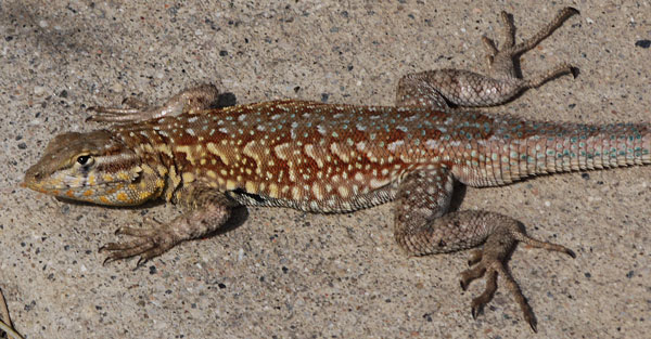
I'm in San Diego and I've purchased my boots, socks, and non-perishable food, and I am as ready as I can be to leave Thursday. I've been able to visit Mom and Dad, Marie, Roy, and Kate, and my friends Don and Judy. While digging up my dad's gardens I came across a Western Blind Snake Leptotyphlops humilis or, as I later decided, more likely a California Legless Lizard Anniella pulchra. My dad said he may have seen one decades ago when I was small. It's the first I've seen. As usual, in my walks at Mission Bay, Mission Beach, the San Diego River, and Ocean Beach yielded many sightings of Dolphins, Snowy Egrets, American Coots, Great Blue Herons, and Ducks of every sort.
Julian Weather Forecast
Thursday, April 25 - AM Clouds / PM Sun, 59, 10%, W at 11 mph
Friday, April 26 - AM Clouds / PM Sun, 62, 0%, NW at 11 mph
Saturday, April 27 - Partly Cloudy, 66, 10%, WNW at 9 mph
Sunday, April 28 - Partly Cloudy, 64, 0%, WSW at 8 mph
Monday, April 29 - Partly Cloudy, 62, 10%, SSW at 8 mph
Tuesday, April 30 - Partly Cloudy, 63, 10%, WSW at 8 mph
Wednesday, May 1 - Sunny, 69, 0%, WNW at 8 mph
Thursday, May 2 - Sunny, 72, 0%, WNW at 8 mph
Friday, May 3 - Sunny, 71, 0%, SW at 8 mph
Thursday, April 25, 2013
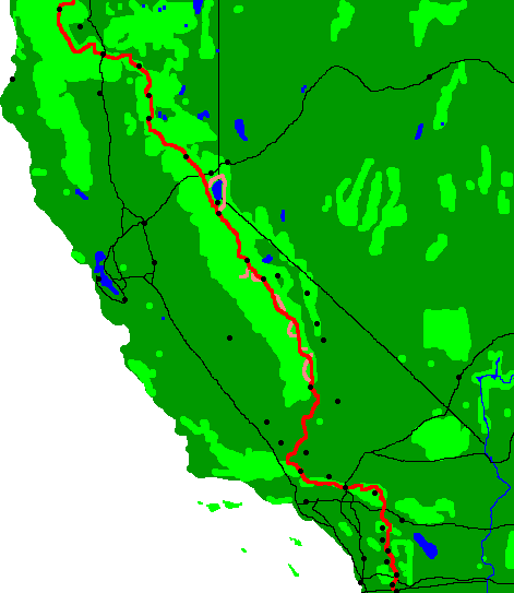
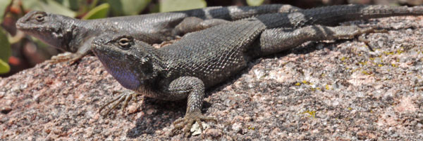
Mary Jean dC drove me to the Mexican border terminus of the Pacific Crest Trail at Campo. She was thrilled with being at the border, seeing the start of the trail, and all of the wildflowers. She went home with a bundle of sage and lupine. Along today's hike were Campo and its railway museum, the San Diego, Arizona and Eastern Railroad, the chicken sheds, the navy radio telescope, and a wind farm to the east. Someone had counted over 114 hikers between Mexico and Lake Morena. There were many snake tracks and some huge Southern Alligator Lizards Elgaria multicarinata. I saw a Mule Deer Odocoileus hemionus and some quail.
Camp: North side of Hauser Canyon
Miles Walked: 16
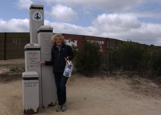
Pacific Mine, Hauser Canyon
On the north side of Hauser Canyon near mile 16.2 is the old Pacific Mine. It is just east of a switchback of the PCT on the north side of Hauser Canyon, and visible from most of the PCT on the south side of the canyon. Between 1921 and 1943 it supplied
87,000 tons of orthoclase feldspar, largely for the porcelain coatings on plumbing fixtures. Quartz was a byproduct and went to pottery and glass manufacture. The products went by truck to Campo and by the same SDAE Railroad tracks the PCT crosses to market.
San Diego Woolly Sunflower Hulsea californica
Occurrence Number: 29
Found?: No
Total Number of Individuals: 0
Phenology: NA
Location Description: Given GPS location was at the corner of paved Jeb Stuart and Sheridan Roads
GPS Accuracy: NA
Habitat Description: The area around the point is today an entirely developed neighborhood of Campo, with houses, Sheriff and Border Patrol stations, and semi-industrial yards. All plants appear to be mowed multiple times annually. There were no plants nearly matching the Woolly Sunflower either at the site or during today's PCT hike, but there were two smaller, non-woolly sunflowers in bloom.
Site Viability: Poor
Visible Disturbances: See above
Threats: See Above
Comments: No photos or gps locations taken. Time 11:15am
Friday, Saturday, April 26, 27, 2013
I met old and new friends and listened to presentations at ADZPCTKO. Best was by a 90 year old guy who had, at age 15, walked on one of the YMCA Teams which completed a relay hike of the PCT in the 1930s. I was right up front and could often see tears of joy welling in his eyes at old memories, and at all the people hiking now. He hadn't talked with anyone outside his family about it since. The journal that had been handed from team to team has since been locked in a fireproof safe, but the old fellow was reunited with it and passages were read. Honestly, today's journals have very similar contents. I found the whole presentation very moving.
Camp: Lake Morena Friday, Buckman Springs Road and Cottonwood Creek Saturday
Miles Walked: 4 20 Friday, 5 25 Saturday
Billygoat and the Israeli National Trail
Billygoat hiked the INT in 2011 with Tigger and Chuck N. He said a local contact (His was Edo) was necessary to understand how to use the post office for general delivery, to rent a cell phone, and to do other set up items that are a bit different than in America. So I should find a local contact. Billygoat mailed himself food but one could easily buy nuts, cheese, salad, olives, and water in every town. Food cost about twice the US price. They often stayed in a Kibbutz, ~$30 breakfast included. Taxis are everywhere and are the equivalent of hitching in the US, but the price should always be negotiated before the ride. They used taxis to access the Dead Sea and Mosada. Jerusalem and the Sea of Galilee are also off trail. If you rent a car also rent a gps (roads are ancient, winding, etcetera) from the same vendor, but it won't suggest routes through the West Bank, so watch maps too to keep routes reasonable. It is very useful to have a phone and they can be rented. For example, water cache locations were often texted to them, and the phone was used to set up lodging. But phone calls to the US were more economical using cards and the many public phones. I should learn the blaze convention because it encodes NOBO vs SOBO, turn information, etcetera. The trail is ~650 miles, passes right through Tel Aviv, is in good condition, and is little used. The Negev Desert has no plants or animals and they found it necessary to pay someone to place water caches. Generally, this cost about $20 for 4 1½ liter bottles. But they found old water caches, were given water by campers, and one could get water by holding up a jug by a road. He hadn't seen buried general use caches (per Tamir) but said they didn't know and so didn't look. Starting about the 25th of March it gets hot in the Negev Desert so hiking is generally NOBO in the spring or SOBO in autumn. Wear long pants and follow other local customs in towns or near groups or people will be less willing to socially engage. But shorts in the desert were fine. Most people are fairly secular. Virtually everything is closed Saturdays. Israel is very crowded at Easter, so avoid that time. There is a current English guidebook that is in print, much improved, and costs $65. They didn't need supplementary maps. Everything about the trail will have a steep learning curve. ATMS are everywhere: larger, less frequent, withdrawals keep cumulative fees lower. Airfare was $1000. He spent $20-50/day. Many people are armed, and soldiers are everywhere, but this is normal and doesn't necessarily indicate a troubled time.
Potomac Heritage Trail
Billygoat hiked the PHT and said it is a paved bike path, with designated camps about every 7 miles, and towns most days. He enjoyed it.
Hiker Gatherings
The 2003 PCT reunion will be in July at Tahoe. The ALDHA West Gathering will be at Camp Augusta between Tahoe and Sacramento September 27-29.
Oregon Coast, Lewis and Clark, and Columbia Gorge Trails
When I discussed a potential future OCT hike, So Far, of Portland and PCT 2003, suggested rather than riding to Astoria to start, I walk down the Columbia River from The Dalles to the coast via either the Lewis and Clark Trail (not LC Highway) or the new Columbia Gorge Bike Path, which uses abandoned sections of highway built in the 1910s. Doing so would add the Columbia River, the transition from chaparral through coastal ranges to coast ecosystem types, and various historical sites to the overall journey. I should stop at reconstructed Fort Clatsop for its excellent visitor center. The Breeze is a bus I might take to the coast from Portland. To The Dalles, I might fly to Portland, take the Max light rail to the Amtrak and Greyhound stations, across the street from each others, and ride one to The Dalles (My source, not So Far, said his understanding of all this was sketchy and I should research it thoroughly). I remember Portland to be a pleasant place to visit, so perhaps some days there might be good.
http://lymedisease.org/ was suggested as an excellent source on tick vectored disease.
Sunday, April 28, 2013
I hiked up to the Lagunas. There were many wildflowers, and the chaparral was fairly green. I saw a Pygmy Short Horned Lizard Phrynosoma douglasii. There was a Honey Bee Apis mellifera hive in an oak tree. There was one entrance where bees usually entered, and another where they both entered and exited.
Camp: Burnt Rancheria Campground
Miles Walked: 20 45
San Diego Woolly Sunflower Hulsea californica
Occurrence Number: 01
Found?: No
Total Number of Individuals: 0
Phenology: NA
Location Description: Given GPS location was at mile marker 5.5 of Buckman Springs Road
GPS Accuracy: NA
Habitat Description: Other than the road, shoulders, and cuts, the area is fairly undisturbed. Chaparral is on the slope to the west, oak trees are along the road, and to the east is a sandy meadow with mixed grass, trees, and scrub.
Site Viability: Excellent
Visible Disturbances: none
Threats: none
Comments: No photos or gps locations taken. Time 05:30-06:30am. Walked from Cottonwood Creek or PCT, mile 6.5, southeast on Buckman Springs road to and 1/4 mile past given gps coordinates. No yellow sunflowers of any species in bloom.
San Diego Woolly Sunflower Hulsea californica
Occurrence Number: 07
Found?: No
Total Number of Individuals: 0
Phenology: NA
Location Description: Chaparral
GPS Accuracy: NA
Habitat Description: Chaparral
Site Viability: Excellent
Visible Disturbances: none
Threats: none
Comments: No photos or gps locations taken. Time 12:30
Monday, April 29, 2013
There were good, though hazy, views to the desert, and for a short time of Cuyamaca Peak and Lake. I saw another Pygmy Short Horned Lizard and probably a Coast Horned Lizard Phrynosoma blainvillii, as well as a 30" Rosy Boa Lichanura trivergata and a stick bug. The Sunrise Trailhead, .25 miles west of the PCT, in addition to a solar well, also had vault toilets, an emergency phone, and access to the Lucky 5 Trail (Sunrise Highway 1.1, PCT 1.6, Loop via PCT 3.8) and the La Cima Trail (Upper Green Valley Trail 1.2, Fages Monument and California Riding and Hiking Trail 2.6, Los Vaqueros Camp 4.5)
Camp: Ridge after Chariot Canyon
Miles Walked: 26 71
San Diego Woolly Sunflower Hulsea californica
Occurrence Number: 06
Found?: No
Total Number of Individuals: 0
Phenology: NA
Location Description: East of campground complex
GPS Accuracy: NA
Habitat Description: Chaparral, trees, slope
Site Viability: Excellent
Visible Disturbances: none
Threats: none
Comments: No photos or gps locations taken. Time 06:15am
San Diego Woolly Sunflower Hulsea californica
Occurrence Number: 10
Found?: No
Total Number of Individuals: 0
Phenology: NA
Location Description: 200' south of concrete helipad in Monument Peak Electronics Complex
GPS Accuracy: NA
Habitat Description: Chaparral, north slope pure manzanita stands in bloom
Site Viability: Excellent
Visible Disturbances: none except in electronic sites
Threats: none
Comments: No photos or gps locations taken. Time 07:30am No sunflowers of any species
San Diego Woolly Sunflower Hulsea californica
Occurrence 11 was some distance to the west side of the highway. I didn't know whether there was a clear route like a trail or whether a prolonged bushwhack would be required. Water was scarce. I chose not to observe occurrence 11.
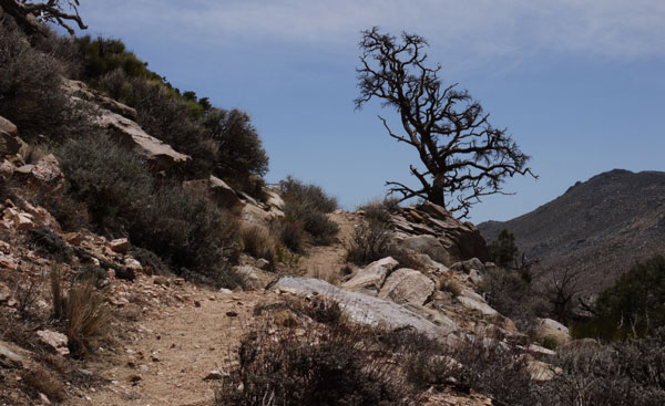
San Diego Woolly Sunflower Hulsea californica
Occurrence Number: 14
Found?: No
Total Number of Individuals: 0
Phenology: NA
Location Description: Chaparral
GPS Accuracy: NA
Habitat Description: Near junction of PCT and Garnet Peak Trail
Site Viability: Excellent
Visible Disturbances: none
Threats: none
Comments: No photos or gps locations taken.
San Diego Woolly Sunflower Hulsea californica
Occurrence Number: 13
Found?: No
Total Number of Individuals: 0
Phenology: NA
Location Description: Pioneer Mail Picnic Area and closed highway to north
GPS Accuracy: NA
Habitat Description: Chaparral
Site Viability: Excellent
Visible Disturbances: Picnic area is mowed, old highway is trampled, but all surrounding areas undisturbed.
Threats: none
Comments: No photos or gps locations taken.
San Diego Woolly Sunflower Hulsea californica
Occurrence Number: 23
Found?: No
Total Number of Individuals: 0
Phenology: NA
Location Description: I walked PCT, didn't visit center.
GPS Accuracy: NA
Habitat Description: Chaparral
Site Viability: Excellent
Visible Disturbances: none
Threats: none
Comments: No photos or gps locations taken.
San Diego Woolly Sunflower Hulsea californica
Occurrence Number: 22
Found?: No
Total Number of Individuals: 0
Phenology: NA
Location Description: along Sunrise Highway, south of Sunrise Trailhead
GPS Accuracy: NA
Habitat Description: undisturbed Chaparral and wide disturbed but regrown area along road
Site Viability: Excellent
Visible Disturbances: none
Threats: none
Comments: No photos or gps locations taken.
Tuesday, April 30, 2013
I saw 2 Coast Horned Lizards, and found an unlisted patch of Woolly Sunflowers. Thanks to all who put water at Rodriguez Tank, Scissors Crossing, and San Felipe Hills. Thanks especially for the trail magic soda at Scissors Crossing. A fire probably burned from Rodriguez Spur Truck Trail through the southern San Felipe Hills some years back.
Camp: 2 miles past the San Felipe Hills water spur trial (To Grapevine Ranch)
Miles Walked: 28 99
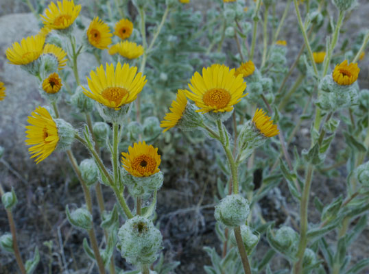
San Diego Woolly Sunflower Hulsea californica
Occurrence Number: New Occurrence A
Found?: Yes
Total Number of Individuals: Thousands
Phenology: 8-20 heads per stalk, mature plants have 20 or more stalks emanating from the root/base, 100% of plants in bloom
Location Description: .1-.5 miles east of Rodriguez Spur Truck Trail along PCT
GPS Accuracy: 11-20 feet
Habitat Description: Grassy, rocky slope dotted with chaparral bushes, probably burned several years ago
Site Viability: Excellent
Visible Disturbances: none
Threats: none
Comments: Many photos taken. gps locations taken at start and end of group. The shape for mapping should be a circle, one of whose diameters is the line between the two gps points. Scattered individual plants along the PCT for a couple miles east of the group. Time 07:30am
Wednesday, May 1, 2013
From Barrel Springs on, in the oak grasslands, I saw many squirrels and several grasshopper species, and I could see the white domes of the observatory on Mount Palomar. The Warner Springs Community Center was a great visit, with showers, burgers, pie a la mode, and a reasonably priced store for through hikers. Billygoat was even shuttling hikers to the post office. The resort is closed.
Camp: Halfway up Agua Caliente Creek in east side campsite with many other hikers. Plenty of Poison Oak and Mosquitos.
Miles Walked: 22 121

Idylwild Weather Forecast
40% chance of rain Monday, May 6. Otherwise, nice temperatures and less than 10% chance of rain.
Warner's Ranch
The area around Warner's Ranch was occupied by Cupeño Indians before John Trumbull Warner received the Rancho San Jose del Valle Mexican land grant and established this successful cattle ranch in the 1840s. The ranch was visited by travellers on the Gila River Trail and the Butterfield Overland Mail Stagecoach Line from the 1840s - 60s. On December 2, 1846, Stephen Watts Kearney stopped shortly before the Battle of San Pasqual. During the Civil War, the ranch hosted the Union Army's Camp Wright. Two adobe buildings built in 1849 and 1857 are registered landmarks. Recently, bankruptcy proceedings and Cupeño Indian attempts to buy back their ancestral homelands are part of the Warner Ranch story.
Thursday, May 2, 2013
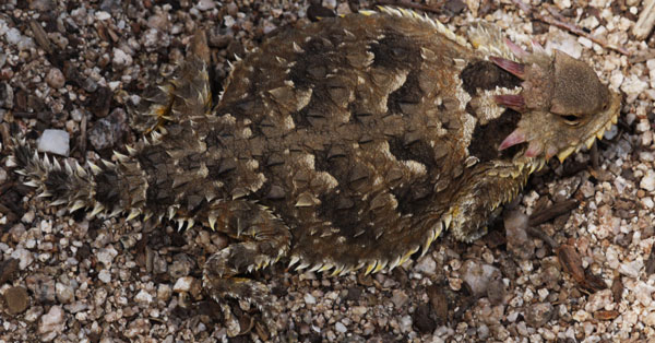
I saw a Garter Snake Thamnophis, a Southern Sagebrush Lizard Sceloporus vandeburgianus, and a Desert Horned Lizard Phrynosoma platyrhinos. I had tacos, potato salad, and strawberries for lunch at Trail Angel Mike's - Thank you!!!
Camp: Canyon after Tule Spring
Miles Walked: 23 144
Friday, May 3, 2013
I saw another Garter Snake and more Southern Sagebrush Lizards. At Pines to Palms Highway 74 Dr Sole had his blister care clinic set up. I've had only one small blister atop my left big toe, and it resolved itself. So I didn't need foot care, but I did enjoy hotdogs and soda there. Soon Taxi Bill offered rides to Idyllwild and back. So I accepted, uploaded the website, arranged for a new rare plants data set to arrive before I get to Big Bear, and enjoyed a couple of beers and an antipasto salad. I returned to the trail in the evening.
Camp: 2 miles after Pines to Palms Highway 74
Miles Walked: 17 161
Saturday, May 4, 2013
I saw another Garter Snake, a juvenile 12" rattlesnake, and more Southern Sagebrush Lizards. I started off the PCT on the Taquitz Valley Trail after Taquitz Creek.
Camp: Taquitz Valley Trail
Miles Walked: 23 184

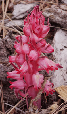
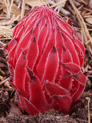
San Diego Woolly Sunflower? Hulsea californica?
Occurrence Number: New B ?
Found?: Maybe
Total Number of Individuals: 15
Phenology: 1 stalk, 6 heads per stalk on mature plants, most plants dying before maturity.
Location Description: Along PCT at and for a few miles north of gps point, between highway 74 and the San Jacinto Range in Riverside County.
GPS Accuracy: NA
Habitat Description: Chaparral, scattered pine and oak
Site Viability: Excellent
Visible Disturbances: none
Threats: none
Comments: Photos and a gps location taken. This plant looks somewhat different than those from the site near Rodriguez Spur Truck Trail. But that could be due to poor soil or water conditions. Please review photos to determine whether these are the correct species. The first series of photos shows one typical sickly looking plant and two that died before growing much.
Sunday, May 5, 2013
There were many patches of snow in the San Jacintos, and brief snow flurries.
Camp: On Descent 5 miles before Snow Creek Road
Miles Walked: 24 208
|
Monday, May 6, 2013
There were bright rainbows and moments of drizzle. ZiggyBear's was a great stop with showers, foot soaks, laundry, and many hikers to talk with. Sharon of PCT2003 thinks I ought to walk the AT southbound starting late August or early September to see more wildlife and fewer people. She recommended the book "Ghost Whisperers" by Model T for history along the AT. She also hiked the Hayduke Trail using only (difficult) hitches for resupply. She got a permit only at Grand Canyon NP.
Camp: ZiggyBear's, Cabazon
Miles Walked: 9 217
Big Bear Weather Forecast
Monday, May 6 - 47F / 28F 60%
Tuesday, May 7 - 47F / 29F 30%
Wednesday, May 8 - 54F / 33F 30%
Thursday, May 9 - 56F / 38F 0%
Friday, May 10 - 62F / 37F 0%
Saturday, May 11 - 68F / 41F 0%
Sunday, May 12 - 71F / 40F 0%
Monday, May 13 - 70F / 37F 0%
Tuesday, May 14 - 67F / 36F 0%
Wednesday, May 15 - 68F / 36F 0%
Tuesday, May 7, 2013
I hiked with Jim L. to Mission Creek. There were moments of drizzle, and we saw a Striped Racer Snake.
Camp: Mission Creek, frogs singing in the night
Miles Walked: 15 232
Wednesday, May 8, 2013
Jim and I walked up Mission Creek and the ridgeline. There was a Poodle Dog Bush patch in miles 235-7. Rain threatened by the end of the day.
Camp: Coon Creek Cabin
Miles Walked: 20 252
Poodle-Dog Bush
The Poodle-Dog Bush or Common Turricula, Turricula parryi is especially bad in the 2009 Station Fire burn area [PCT miles 400 - 441] but also may be found in the 2009 Sheep Fire burn area [PCT miles 345 359] and other burn areas in southern California. Wear long sleeves and long pants in California Section D. Poodle-dog bush causes severe skin irritation if touched. Swelling, rash and itching appear twelve hours to two days after contact. It can raise blisters lasting as long as two weeks. This contact dermatitis is due to prenylated phenolics exuded by hairs (glandular trichomes) of the plant. The principal irritants are derivatives of farnesyl hydroquinone and 3-farnesyl-P-hydroxybenzoic acid. It is a woody shrub with purple bell shaped flowers and a rank smell.
Source: PCTA Brochure
Thursday, May 9, 2013
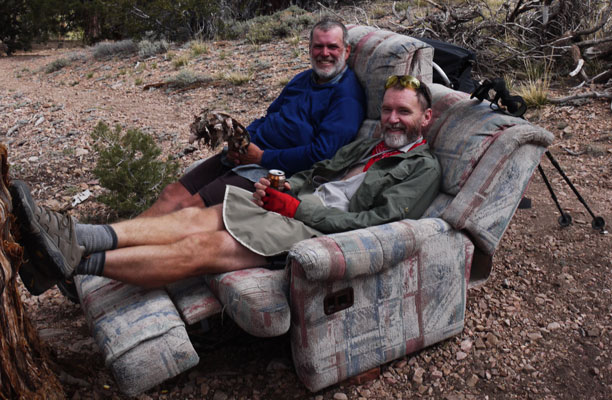
Jim and I visited an excellent cache of water, soda, cookies, and oranges. There was even a recliner couch! The Doble or Lucky Baldwin Mine operated before 1870 and again, 1917-48, according to some local hikers who were out following the route of the former flume from Van Dusen Canyon to the mine site. The rusting steel mine works at a cut through a ridge are visible high above the PCT. We also found a mine tunnel and tailings pile on the PCT in the area. Around 5:30 there were large virga and thunder storms to the east, and occasion rain locally. The weather seemed to be deteriorating, so we camped early. Local lightning followed.
Camp: Doble Spring Trail Camp
Miles Walked: 22 274
Friday, May 10, 2013
There were lizards all day, and Beaver Castor canadensis dams in Holcomb Creek. We ran into only one other thruhiker today, much less than usual.
Camp: Where the PCT, Holcomb Creek, Crab Flats Road 3N16, and road 3N93 meet.
Miles Walked: 24 298
Saturday, May 11, 2013
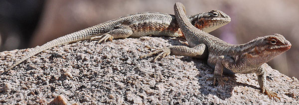
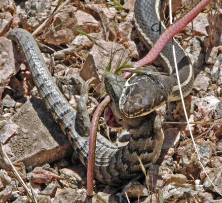
I saw a California Striped Racer Masticophis lateralis subduing a Southern Alligator Lizard Elgaria multicarinata. Early in the contest there was much writhing around on the steep, rocky slope. I could see both animals breathing heavily. The snake's grip was on the lizard's head originally, but over time the snake released and grabbed again repeatedly, moving to the throat where the lizard could be strangled by the snake's strong jaws. As the lizard succumbed, the snake took his prey out into the grasses, and my observation and photography session ended.
Deep Creek Hot Springs provided a welcome bath and much socializing with other PCT hikers. One had gone to town for party supplies for others staying at the springs. I had a little wine and whiskey before walking out. Boy did I feel the vertigo while walking the steep canyon walls with a little booze in my blood!
A family was lost, walking out the PCT rather than climbing this canyon walls from the hot springs. Jim and I gave them some directions, and I gave them a headlamp I had found on the Arizona Trail, as it would probably be dark by the time they returned to the springs and then climbed the hill to their car.
Camp: Second Deep Creek Bridge, many bats and birds catching flying bugs in crepuscular hours
Miles Walked: 18 316
Sunday, May 12, 2013
Jim and I walked to a powerline road after Grass Valley and walked out to Highway 173 to meet his fiancé Claudia for a nice night in Lake Arrowhead.
Flume in Deep Creek Canyon
There was an old flume on the east side of Deep Creek starting perhaps a mile upstream of the second/last bridge, and continuing past the Mojave Dam. The PCT follows the flume from the bridge to the dam. A little upstream of the bridge I found several initials and a date of February 22, 1947. In one area the flume had been repaired with galvanized half pipes which looked to me more recent than 1947.
Fancy Resort: Lake Arrowhead
Miles Walked: 8 324
Wrightwood Weather Forecast
Monday, May 13 - 84F / 53F 0%
Tuesday, May 14 - 78F / 49F 0%
Wednesday, May 15 - 70F / 47F 0%
Thursday, May 16 - 69F / 46F 0%
Friday, May 17 - 66F / 46F 0%
Saturday, May 18 - 67F / 48F 0%
Sunday, May 19 - 74F / 49F 0%
Monday, May 20 - 74F / 49F 0%
Tuesday, May 21 - 71F / 47F 0%
Monday, May 13, 2013
I returned to the PCT about 1pm and resume hiking a deliberately slow pace to compensate for hot weather. For less than an hour I was well downwind of a wildfire, with a sweet, pleasant smoke smell, and some haze, but no ash and no visible smoke column. There were two excellent magic caches, and I enjoyed water, fruit, and a hard boiled egg. I saw two shy rattlesnakes slithering off to cover, and Steller's Jays. Signs have been warning of a threatened Southwestern Arroyo Toad.
Camp: 9 miles short of Intertsate 15.
Miles Walked: 15 339
Tuesday, May 14, 2013
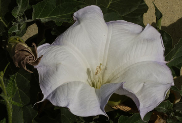
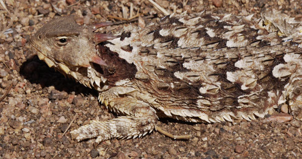
I reached the I15 McDonalds, 9 miles, before 9am, and caught up on this journal and emails. Jimson Weed Datura stramonium was growing along the frontage road, with very healthy, pretty trumpet shaped flowers, and with developing flowers nicely rolled in a spiral fashion. There was Poison Oak and Poodle Dog Bush too, making this quite a day for toxic plants. But I saw Miner's Lettuce and ate some new pine needles, so there are some friendly plants also. I saw two rattlesnakes Crotalus and a Gopher Snake Pituophis catenifer, two Horned Lizards Phrynosoma, a big Southern Alligator Lizard Elgaria multicarinata, and many other lizard types.
Camp: 7 miles before Guffy Camp, ridge with great view of I15/US395 junction and surrounding desert areas
Miles Walked: 26 367
Wednesday, May 15, 2013
There was smoke smell and haze, perhaps from controlled burns. The chaparral is fairly moist, so no big fire danger, and no warnings to hikers have been issued. There were patches of snow ip high.
Camp: 1 mile after Baden Powell summit, many swifts catching bugs
Miles Walked: 21 388
Thursday, May 16, 2013
The PCT is closed from Eagles Roost to the Burkhart Trail due to the endangered Mountain Yellow Legged Frog. Therefore I detoured from Islip Saddle northeast on the South Fork Trail, then west on the Punchbowl Trail, then south on the Burkhart Trail. I met no other hikers on the reroute. Perhaps most other PCT hikers continued on the PCT to Eagles Roost, then walked Highway 2 to Buckhorn Campground, regaining the trail there. I saw a Kit Fox Vulpes macrotis on the South Fork Trail, where there were also poles, wires, and insulators from old ground loop radiotelephones.
Camp: 1 mile after Cruthers Creek atop ridge
Miles Walked: 22 410
Friday, May 17, 2013
I saw plenty of Poodle Dog Bush and there was some threat of rain (no rain materialized).
Camp: 1.5 miles after Little Rock Creek Truck Trail
Miles Walked: 22 432
Saturday, May 18, 2013
There were great views from the ridgelines. At camp an animal smaller than a deer stotted away, and I saw bats. Some rodent kept returning and bothering me all night. This was the second time this trip it happened. The rodents find something about the web material very appetizing. The first time, a 3/4" strap holding the top flap/pockets in place was chewed completely off and carried away. Tonight, the critter chewed half way through a shoulder strap. These are clean parts of the strap, so it's not salt from sweat that is so alluring. I guess in the future if I get multiple visits I'll have to pack up in the middle of the night and change camps, or my pack will be chewed to uselessness. The Deuter pack has so far been used on this trip and a few hundred miles of the Arizona Trail.
Camp: 1.5 miles short of Soledad Canyon Road
Miles Walked: 33 465
Sunday, May 19, 2013
I walked through Vasquez Rocks to the Saufleys' Hiker Heaven.
On the way, I bought groceries to last me to Kennedy Meadows. I supplemented these with interesting stuff from the hiker boxes. The idea is to skip Mojave and Tehachapi, both of which are long hitches off trail, and both of which are very spread out, requiring much walking around town.
By late afternoon, my chores were done, and I felt more like walking than sitting around at the Saufleys'. So I hiked out, and on into the night. The moon was just over half full. The trail was a bit rocky, so the depth perception was not as good as I might like. But the moon is getting fuller, and with more light, some of the flatter sections in the Mojave Desert may be quite amenable to night hiking. And besides, night hiking has its own charms. The lights of Agua Dulce were below me, and the stars above. Burnt Manzanita skeletons cast black shadows on the trail, looking much like great fractures in the earth. White flowers fluttered like brilliant white ghosts. The breeze was cool...
Camp: Same ridge as ten years ago, Pelona Ridge, 8 miles out of Agua Dulce, by road 6N07. A rodent bumped into me, the hid under my sleeping mat, then under my pack, before I chased him away for good. At least he didn't return and snack on my pack.
Miles Walked: 20 485
Mojave Weather Forecast
Sunday, May 19 - 83F / 60F 0%
Monday, May 20 - 89F / 62F 0%
Tuesday, May 21 - 89F / 61F 0%
Wednesday, May 22 - 79F / 55F 0%
Thursday, May 23 - 76F / 55F 0%
Friday, May 24 - 80F / 56F 0%
Saturday, May 25 - 83F / 57F 0%
Sunday, May 26 - 84F / 59F 0%
Monday, May 27 - 85F / 60F 0%
Tuesday, May 28 - 85F / 59F 0%
Monday, May 20, 2013
Manzanita apples were forming, perhaps 3/8" in diameter, green and sticky. I ate Miner's Lettuce and Wild Onions. On this trip, I have also found Mint. There was also plenty of Poison Oak and Basket Brush. I enjoyed all of the Andersons' caches at Bouquet, Oasis, and Red Carpet, and socializing at their house, the Casa de Luna or Lunatic Lounge. The taco salad dinner was as great as I had remembered. A hiker sleeping at the Oasis had woken to find a cougar crouching 10' away, and others felt they had been followed. There is a mother and cub known to be living in the area.
Camp: Behind the Andersons', in the enchanting manzanita grove with many flat spots in niches for hikers
Miles Walked: 18 503
Tuesday, May 21, 2013
I saw a Skunk, a Rattlesnake, two Horned Lizards, and some lizards with iridescent color blotches.
Camp: Before Red Rock Water Tank on Liebre Ridge
Miles Walked: 26 529
Wednesday, May 22, 2013
Today's walk started high on Liebre Ridge among pine and oak groves and ended on the floor of the Mojave Desert among Joshua Trees along the Los Angeles Aqueduct. Along the way I saw a Bobcat Lynx rufus and visited Richard Scagg's Hikertown. He and I reminisced about his early days with hikers, and how I slept in the barn next to an open window through which the horses would stick their noses to say hi. Today he has quite a setup, with many western themed cabins, showers, laundry, and even a chef making dinners for the hikers. Mine was pot roast, excellent mashed potatoes, corn on the cob, cauliflower, a large garden salad, bread, and ice cream. Seconds were included in the $10, but I was stuffed. In the six hours I was there I also ate a great burger at a store a few miles east, and Richard served me a hotdog, chicken salad, green salad, cookie, and orange juice for lunch.
Camp: 5 miles after Highway 138 at the turn in the PCT and Los Angeles Aqueduct
Miles Walked: 21 550
Thursday, May 23, 2013
A cool wind blew all day, making this a very pleasant walk through the Mojave Desert. There was not much wildlife.
Camp: 8 miles short of Tehachapi Willow Springs Road
Miles Walked: 27 577
Friday, May 24, 2013
The Wind Turbines between Tehachapi Willow Springs Road and the 58 Freeway are much larger and more numerous than during my 2003 PCT hike. I saw one small Horned Lizard and a few birds, but little wildlife in general.
Camp: 6 miles after crossing the bridge over Highway 58
Miles Walked: 23 600
Charlotte's Phacelia Phacelia nashiana
Occurrence Number: New Occurrence A
Found?: Yes
Total Number of Individuals: Millions
Phenology: 1-10 mature heads per stalk, 10% of plants in bloom in higher areas with many plants, 0% in bloom in lower areas, which have fewer and more isolated plants
Location Description: Along PCT from Tylerhorse Canyon to Highway 58
GPS Accuracy: GPS not used
Habitat Description: Pine stands, Chaparral, Burn Recovery Areas, and grasslands
Site Viability: good
Visible Disturbances: Plants Growing centered in the trail tread are trampled
Threats: Motorcycle activity causes severe damage to soil surfaces in this area. Cattle grazing occurs. Plant density is very high in the disturbed soil of and adjacent to the trail tread; trampling occurs.
Comments: Photos taken. I had noticed similar plants on earlier days, but only started to examine them today. The flowers are quite small and gusty winds make examination and photography difficult, but the style appeared to be cleft for most of its length, thus more like Phacelia nashiana than P. campanularia. Concentrations on plants occur in the disturbed soil along the trail, but many plants grow in non-disturbed soils well off trail.
Saturday, May 25, 2013
I saw a mother Mountain Quail Oreortyx pictus and about 8 chicks. She had walked downslope across the trail, but on seeing me, ran back up, gathered the covey, hid behind a tree, and made alarm cries. There were many wind turbines and a recent burn had killed many trees.
Camp: 1½ miles before Hamp Williams Pass
Miles Walked: 22 622
Sunday, May 26, 2013
In early morning there were tracks of a large Black Bear Ursus americanus. Midday had old mining machinery, a water ditch, and mines and tailing piles. Late afternoon brought gusts strong enough to blow me off balance and out of the trail tread.
Camp: 2 miles before crossing Dove Spring Canyon Road, west slope of Pinyon Mountain
Miles Walked: 25 647

Monday, May 27, 2013
McIver's Cabin didn't seem any more run down than I remember from 2003, and it even had a new asphalt roll roof. The spring pipe was not flowing, but there was water in seep holes upstream. There was toilet paper all about, and some stink too, so I don't recommend it as a water source.
I saw an old bear scat and took a picture of a Kangaroo Rat Dipodomys.
The lightning caused Jacks Creek Fire of August 1997 in the McIver area has recovered to chaparral, with replacement trees growing only near tree stands which survived the fire. The fire was in the Sequoia National Forest’s Kiavah Wilderness, and 5693 acres burned.
I have seen Phacelia, but not in bloom. Tomorrow I'll survey all the historic sightings, but without blooms, I won't be able to identify to species.
Camp: A mile after McIver's Cabin
Miles Walked: 25 672
Tuesday, May 28, 2013
I saw 3 Mule Deer in the morning, and in the waning light of evening, I treed a small Black Bear. As I approached, he climbed a little, and was calling "ubb ubb". I backed off, and he climbed down and stood leaning against the tree. We were now in a standoff for a while, with me encouraging him to leave with claps and shouts, and him staring back, unsure what to do. Eventually I walked while talking and clapping past him, as he reclimbed the tree. As I waked away, he descended and went back about his business.
I had planned to pick up water and use the toilet at Walker Pass Campground, but Chief's wife showed up looking for him. I had seen him late yesterday, and knew he was hiking in by noon, and let her know. I also knew that she had set out a phenomenal goodie cache at highway 58 / Tehachapi, so when she invited, I stayed a while. We had salads, fruits, bagels, sandwiches, sodas, beers... a regular heaven for hikers. Her neighbor, Postman Dan, had made some individual cheesecakes, each incorporating fresh strawberries and blueberries. Plus, I got a ride down to Onyx, where my cell phone worked and I called my parents and brother. I hung out until late afternoon resting, digesting, and socializing with the other hikers.
On reaching Walker Pass a few minutes later, I talked a while with Terri, who was on a road trip, and she gave me tangerines and apples for the trail. Then, as I was leaving, I spotted something atop the monument to Joseph Walker, which turned out to be an unopened bar of excellent Dark Chocolate.
All the extra food and rest primed me to easily walk the long ascent from Walker Pass. It was a great day.
Camp: South of Owens Peak
Miles Walked: 15 687

Charlotte's Phacelia Phacelia nashiana
Occurrence Number: 12
Found?: Yes
Total Number of Individuals: Hundreds
Phenology: 1% in bloom, most past bloom
Location Description: Along PCT
GPS Accuracy: 12 feet
Habitat Description: Pine stands, Chaparral, Burn Recovery Areas
Site Viability: good
Visible Disturbances: None
Threats: None
Comments: Photos taken. Styles cleft ~75%
Charlotte's Phacelia Phacelia nashiana
Occurrence Number: 51
Found?: No
Charlotte's Phacelia Phacelia nashiana
Occurrence Number: 70
Found?: No
Charlotte's Phacelia Phacelia nashiana
Occurrence Number: 21
Found?: Yes
Total Number of Individuals: Hundreds
Phenology: 1% in bloom, most past
Location Description: Sandy slopes along PCT
GPS Accuracy: 12 feet
Habitat Description: Sandy slopes along PCT
Site Viability: good
Visible Disturbances: none
Threats: none
Comments: Photos taken. Plants grow between 2 gps points, a greater length of trail than previously described.
Charlotte's Phacelia Phacelia nashiana
Occurrence Number: 22
Found?: Yes
Total Number of Individuals: 200+, see below
Phenology: 1% in bloom, most past
Location Description: along PCT in 3 separate groups, each 50 feet in diameter
GPS Accuracy: 12 feet
Habitat Description: Pine stands, Chaparral, steep sandy slopes
Site Viability: good
Visible Disturbances: none
Threats: none
Comments: Photos taken. 20 plants at first gps point, 6 at second, ~200 at third
Wednesday, May 29, 2013
All the extra fruit and chocolate made for some great breakfast stops. The apples were crisp and sweet, and the tangerines tasty. In Spanish Needle Creek Canyon I found very fragrant Mint and Wild Roses. The mint had a very strong flavor.
Camp: ¼ Mile South of Fox Mill Spring
Miles Walked: 23 710
Charlotte's Phacelia Phacelia nashiana
Occurrence Number: 36
Found?: No
Thursday, May 30, 2013
I explored Fox Mill a bit, and saw many tunnel and open pit mines. There was a 24" Garter Snake Thamnophis. A swim in the South Fork Kern River was a pleasant diversion on a hot afternoon, plus I rid myself of the several pounds of dirt I had collected since my last shower at Richard Scagg's Hikertown in West Antelope Valley.
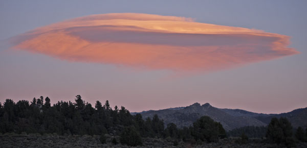
I walked the 20 miles to the Kennedy Meadows Store by 2:30pm. I had a great burger for lunch, and a steak, baked potato with sour cream, corn on the cob, salad, roll, and cake and ice cream for dinner. Various snacks too. Ice cold beers were being tossed about like confetti. Conversations about every trail and other subjects of every sort were excitedly pursued. All the hikers were in great spirits after completing Southern California's 702 miles, and were anticipating the beautiful High Sierra section. As the day waned, hikers moved down to Trail Angel Tom's place. There was some great pork and pasta there, and the revelry continued. As the sun set, a gorgeous lenticular cloud formed to the south. I returned to the trail in the gathering darkness.
Camp: ¼ Mile North of the road to Kennedy Meadows. Obsidian chips were all around my bed.
Miles Walked: 22 732
| Adventurers and Scientists for Conservation |
|---|
|
For the first time, this year I volunteered with Adventurers and Scientists for Conservation to collect data on rare plants in California and to catalog Pika locations. |
|
San Diego Woolly Sunflower Hulsea californica |
|
American Pika Ochotona princeps |
| Pre - Trip Planning | ||||||||||||||||||||||||||||||||||||||||||||||||
|---|---|---|---|---|---|---|---|---|---|---|---|---|---|---|---|---|---|---|---|---|---|---|---|---|---|---|---|---|---|---|---|---|---|---|---|---|---|---|---|---|---|---|---|---|---|---|---|---|
|
Schedule
Eastern Sierra Transit
Water |
||||||||||||||||||||||||||||||||||||||||||||||||
| Pre - Trip Planning | ||||||||||||||||||||||||||||||||||||||||||||||||