Monday, April 7, 2003
 Dan got a late start. He planned on starting his hike on Sunday, April 5, but his family wanted to hold a "Last Supper" before he departed. Monday, the cash machine wouldn't let him have any travel money. So the latest information was he planned on starting Tuesday morning. (Gene)
Tuesday, April 8, 2003, 7:30 AM
Dan was driven to the southern end of the Pacific Crest Trail, near Campo California. He was dropped off, oriented himself north, and said his good-byes. Dan became officially part of the PCT. (Gene)
Tuesday, April 8, 2003
My dad drove me to the border at Campo, and I set off. Within 5 minutes, my big water bottle fell off my belt and cracked. I quickly drank what I could and continued with only a 2 quart carrying capacity. During the day, I saw a Rosy Boa Snake (a rare sight) and six Border Patrol Agents. In retrospect (I wrote this from notes 2 weeks later), the first day was definitely the toughest. I had to make adjustments to get my pack to fit, establish a proper pace, and of course I was dehydrated as a result of the water bottle problem. Still, a twenty mile first day was nothing to sneeze at. (Dan)
Camp: Lake Morena
Miles Walked: 20
Wednesday, April 9, 2003
I saw no people all day. But I did meet up with a King Snake. (Dan)
Camp: Between Long Meadow and Morris Meadow
Miles Walked: 20
Thursday, April 10, 2003
 I re-supplied at the Laguna store, including two more quart bottles to solve my water carrying problem. The folks there were very friendly. One was new, and we joked about my basket being a great training aid since I was pretty much buying one of everything in the store. The trail above Oriflame Canyon was covered with sand and rocks which had slid down since all the vegetation was burned off in the Pines Fire of fall 2002. I twisted my ankle on this poor footing. It took two weeks before the ankle finally stopped hurting. Strong, gusty winds started, occasionally blowing me out of the trail tread. I camped in a rock formation above Oriflame Canyon to help shelter myself from the winds, as all the chaparral was burned. (Dan)
Camp: Above Oriflame Canyon
Miles Walked: 19
Friday, April 11, 2003
 I met Steve above Oriflame Canyon and hiked with him to Chariot Canyon. He had section hiked most of the trail from the Mexican border to Mojave. I saw a California Horned Lizard in Rodriguez Canyon. Then later, I saw a King Snake probing rodent holes looking for lunch. Around noon I noticed cirrostratus clouds forming in the north. By evening, cirrostratus clouds were to the north and south, as well as mountain effect clouds lining the Laguna through Volcan Mountains. A huge, bright halo formed around the moon, and contrails within the halo were slewing rapidly across the moon. I knew I had some horrible weather coming in a day or two. I camped southwest of Scissors
Crossing. (Dan)
I met Steve above Oriflame Canyon and hiked with him to Chariot Canyon. He had section hiked most of the trail from the Mexican border to Mojave. I saw a California Horned Lizard in Rodriguez Canyon. Then later, I saw a King Snake probing rodent holes looking for lunch. Around noon I noticed cirrostratus clouds forming in the north. By evening, cirrostratus clouds were to the north and south, as well as mountain effect clouds lining the Laguna through Volcan Mountains. A huge, bright halo formed around the moon, and contrails within the halo were slewing rapidly across the moon. I knew I had some horrible weather coming in a day or two. I camped southwest of Scissors
Crossing. (Dan)
Camp: Scissors Crossing
Miles Walked: 19

|
It didn't rain all day, but cumulus cloud coverage was 80% at first light, 50% at noon with some cirrostratus clouds showing, and 90% by evening. Drizzle started during the night. (Dan) Camp: North of Highway S22 near Barrel Springs Miles Walked: 24 |
Sunday, April 13, 2003
I hiked towards Warner Springs Ranch in drizzle. Even though I was already wet and cold, I took a bath in a stream as I was filthy black from the Pines Fire ashes. Even so, I was horrified later when the simple act of washing my hands in the palatial locker room at the Warner Springs Golf Course splattered black stuff everywhere. I probably spent more time cleaning the sink and mirror than myself. At lunch there, I met Meadow Mary, Florida Bob, Billygoat, and Soupbean. We rented a room to hole up during the storm. There was no more rain all day, and the sky cleared at night. Still, at the resort we had access to satellite weather. It predicted heavy storm activity for Monday, so we decided to stay 2 nights. I really enjoyed the large hot spring swimming pool. (Dan)
Hotel: Warner Springs Resort
Miles Walked: 9
Monday, April 14, 2003
Dan sent a post card from Warner Springs. He arrived there Sunday and planned on staying Monday night, also. He said he was doing about 20 miles a day. So far, his hike had been good, but he was putting up with a lot of mist and rain at Warner Springs. (A rain storm came through San Diego Monday afternoon and evening.) He planned to meet up with friends in Idyllwild, CA the next weekend. (Idyllwild is about 180 miles from the start of the PCT at Campo.) (Gene)
Monday, April 14, 2003
All reports were of very heavy weather in all the surrounding mountain areas. But with only light mist at the resort, I was itching to get going. I met Lynn, another through hiker. (Dan)
Hotel: Warner Springs Resort
Miles Walked: 0
 |
Tuesday, April 15, 2003
 I hiked out of Warner Springs with Lynn, and we made it to Comb's Peak to
camp. At 5595 feet, this was the highest trail elevation nearby. There were 4 inches of snow in our camp.
Cloud coverage varied from 80% to 100% throughout the day, but the sky cleared completely in the waning light of evening. It was a very cold night. (Dan)
I hiked out of Warner Springs with Lynn, and we made it to Comb's Peak to
camp. At 5595 feet, this was the highest trail elevation nearby. There were 4 inches of snow in our camp.
Cloud coverage varied from 80% to 100% throughout the day, but the sky cleared completely in the waning light of evening. It was a very cold night. (Dan)
Camp: Comb's Peak
Miles Walked: 20
Wednesday, April 16, 2003
 The sky was clear and cold in the morning, with lots of frost. I saw 2 California Horned Lizards and tracks from 3 different Bobcats and a pack of Coyotes Mule Deer tracks from tiny fawn to adult sizes were also on the trail. I saw tadpoles in a pool in the next stream north from Tule Springs. Although we willingly drank the water from Tule Stream while still there, after it had warmed up it tasted so bad that we calculated the exact amount we needed and dumped the rest in a bird tank. Between 1 pm and nightfall, cumulus cloud coverage increased from 0% to 85%, then suddenly cleared with perhaps 2% cirrostratus clouds. (Dan)
Camp: West flank of Table Mountain
Miles Walked: 20
Thursday, April 17, 2003, 10:00 AM -
Dan called to confirm the rendezvous in Idyllwild. He was at the Pines to Palms Highway (74) and expected to arrive in Idyllwild early evening on Friday (weather permitting) or early Saturday morning. He met a woman from Maryland who was hiking with him. So far so good and he met other "crazies" like him on the trail. Other than the wet weather, it was good going. He was really looking forward to washing his clothes in the Laundromat in Idyllwild. (Gene)

|
I had an excellent turkey sandwich at the Paradise Corner Cafe. I saw tracks from bobcats, deer, coyotes, raccoons, and a mountain lion and camped just shy of Cedar Springs (mountain lion tracks ran right through the camp). The sky repeatedly switched from mostly clear to totally overcast throughout the day. In the evening, there was heavy fog, high winds, and light snow falling. (Dan) Camp: Ridge just south of Cedar Springs Miles Walked: 19 |
Friday, April 18, 2003
Up to 1 1/2 inches of Rime Ice had formed on all exposed foliage during the night. There was up to 8 inches of snow on the trail, more in drifts. We got to the north face of Red Taquitz in the late afternoon. There, in the lee of the mountain, 2-3 feet of snow had accumulated, totally covering the trail. The fog limited visibility to 100-200 feet. With no good way to navigate, we decided the prudent thing to do was to backtrack to the nearest west-exiting trail and go to Idyllwild. We backtracked over the thickest snowpack before nightfall and camped northeast of Red Taquitz Peak. The sky cleared at 8:30 PM. (Dan)
Camp: Northeast of Red Taquitz Peak
Miles Walked: 15
|
The sky was clear, with no fog, but we continued backtracking, eventually going out the Spitler Peak Trail. A very nice lady with a big dog gave Lynn and me a ride to Idyllwild, where we met up with Melodie and Vonda, friends from my former job, and camped with them at the state park campground in Idyllwild. (Dan) Camp: State park campground in Idyllwild Miles Walked: 15 |

|
Sunday, April 20, 2003
Lynn and I got two rides down to the intersection of the PCT and Interstate 10. Due to the uncertain nature of the impending weather, and the snow pack, we had decided to delay the San Jacinto bit of the hike for a week or so. In the MESA Wind Farm, I saw one tower completely twisted like a corkscrew, with the blades scattered about the ground. (Wind Energy) Along the trail, I hiked up Yucca Peak. In Teutang Canyon, I saw a battle between a caterpillar and some ants. The caterpillar was valiantly struggling, but with several ants on top stinging, and more below carrying him to the ant colony, the caterpillar was doomed. Lynn and I camped in the alluvial plain of Whitewater Canyon near Gold Canyon. (Dan)
Weather: Clear in morning to windy and partly cloudy in the afternoon.
Camp: Whitewater Canyon
Miles Walked: 10
Monday, April 21, 2003
At 10:30 AM, Lynn decided to turn back. I continued on and soon met two inmate crews hard at work on the trail just before it dropped to Mission Creek Road. Navigation and bushwhacking slowed my progress in the canyons of Mission Creek. I saw lots of bobcat and deer tracks. The sky was overcast all day. I camped in the side canyon mentioned in the guidebook, about 16.3 miles from the previous night's camp. Starting at midnight, icy spherical bits up to 1 millimeter in diameter fell. (Dan)
Camp: Beside trail in side canyon on ascent from Mission Creek.
Miles Walked: 16.3
Tuesday, April 22, 2003
The wind was howling as I came up out of Mission Creek Canyon onto the exposed ridgelines. I hiked in every stitch of clothing I had to stay warm. My water froze in my bottle while hiking. A miniscule but constant amount of snow fell all day. From its consistency, I suspected that it was not new snow, but old stuff blown off higher peaks. There was minor accumulated snow on north faces: My ice axe was a comfort but not really required. I saw bobcat and deer tracks, and saw two tigers and a bear at an exotic animal ranch where the trail first approaches Highway 38. During occasional clear periods, I had great views of the surrounding mountains and deserts. (Dan)
Camp: Arrastre Trail Camp
Miles Walked: 20
Wednesday, April 23, 2003
My water filter and water bottles froze overnight, but the day turned out to be perfect hiking weather, with clear, sunny and breezy conditions all day. I met Bill McConnel, the Pacific Crest Trail Association volunteer coordinator for this stretch of trail, at the ridgeline of Gold Mountain. He was mapping trees blown down across the trail for removal in a few days. I agreed to map out the rest of the trees to Van Dusen Canyon Road. Bill met me there a few hours later and then took me on the grand tour of all the stores I would need to visit to re-supply. What a great guy. (Dan)
Motel: Motel 6
Miles Walked: 20
Thursday, April 24, 2003
I edited this journal at the Big Bear Lake Library. I also re-supplied and rested. Lynn and I hooked back up and planned to travel back down to Lake Morena for the kickoff party Friday to Sunday, then go finish the part we missed in the San Jacintos. (Dan)
Motel: Motel 6
Miles Walked: 0
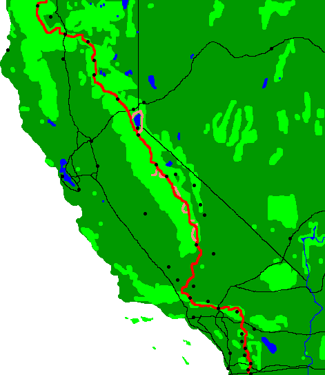
Gene's Note: Big Bear City is about 270 PCT miles from the Mexican border. Dan and Lynn took an arranged ride to the Lake Morena party, then back to Idyllwild to continue their journey.
Friday, April 24, 2003
Dan and Lynn got a ride to the PCT Day Zero party at Lake Morena, where several of Dan's friends came out to meet him. Sunday, they rode back to Idyllwild to finish the parts of the trail they missed because of last week's snow in the San Jacinto mountains. Rides both ways were provided by Stephen Taylor, who has hiked the PCT multiple times, the first in 1977. The PCT Day Zero party is an annual event for PCT hiking enthusiasts. On Sunday, some of hikers are bussed to the southern end of the trail to start their thru-trail hike, thus the "Day Zero" name for the event.) (Gene)

|
The PCT Day Zero Party was great. I picked up nine books and some food from the hiker box. I got to meet a bunch of other hikers. We swapped a lot of good information. The days were beautiful and sunny. And a few of my friends came out from San Diego to say hi. (Dan) Camp: Lake Morena Miles Walked: 0 |
Sunday, April 27, 2003
 I hiked up the Devil's Slide Trail, climbed Taquitz Peak to the Fire Tower, and backtracked across Red Taquitz to tag up with where I had left off. There I saw the rotted tree at right that looks just like a dog. There were clouds and heavy contrails over the desert to the east, with high winds and clear skies overhead all night. I finished reading Rip Van Winkle and The Legend of Sleepy Hollow. (Dan)
Camp: North slope of Red Taquitz
Miles Walked: 12
Monday, April 28, 2003
I hiked over to the Fuller Ridge area in nice weather. I met Lynn backtracking from Fuller Ridge due to the still extant navigation problems. Then, fog rolled in and I spent the rest of the afternoon unsuccessfully trying to navigate to Fuller Ridge. In the process, I really slashed up my legs bushwhacking. I also postholed a lot of rotten snow (there were 2-3 feet of snow on all north faces in the San Jacintos). I lost one expensive brand new Merino Wool sock of a pair I had just bought in Big Bear. The afternoon weather was fog, not too dark cumulus clouds, and where you could see through, cirrostratus clouds. I finished a book of Irish Fairy Tales. (Dan)
Camp: Near the junction with the Marion Ridge Trail
Miles Walked: 15
Tuesday, April 29, 2003
With totally clear weather, I began hiking again towards Fuller Ridge. I soon met Lynn, then hiking with Kit and Di, a couple from the UK. The four of us found our way to the ridge and down. About halfway down to the desert floor, I met Brian, another through hiker. Soon after, Lynn and I each dug
seep holes to get water. Lynn's was far better than mine, since its water cleared of silt, and did not clog the water filter, as mine did. My left ankle, which had been feeling fine a few days earlier, hurt a little again after the junky snow I had been in for a couple of days. The weather was clear and windy with light gray cumulus clouds to the west. I finished a book of Edgar Allan Poe poetry. Our camp was halfway down to the desert floor. (Dan)
Camp: halfway down to the desert floor
Miles Walked: 15
Wednesday, April 30, 2003
There were high and gusty winds all last night, and cirrostratus clouds in the northern and eastern skies at dawn. In addition, there was a cloud layer halfway up the San Gorgonios. Down on the desert floor, I saw a dead horned lizard; maggots inside were wiggling the tail and randomly bulging the abdomen. A few minutes later, I saw another horned lizard who was remarkably calm, and it let Di get some close-up photos. I fixed up a decrepit monument to someone who had died along the trail. We stayed at the Pink Motel, a nice oasis for PCT hikers provided by the Middletons (Thanks). There, Kit made a baseball of a sack of dirt, some carpet padding, and a few rubber bands, and he and I spent a while pitching and batting. Cirrostratus clouds formed overnight. (Dan)
Camp: Pink Motel
Miles Walked: 12